Cleora, Oklahoma facts for kids
Quick facts for kids
Cleora, Oklahoma
|
|
|---|---|

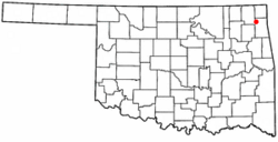
Location of Cleora, Oklahoma
|
|
| Country | United States |
| State | Oklahoma |
| County | Delaware |
| Area | |
| • Total | 12.17 sq mi (31.53 km2) |
| • Land | 11.85 sq mi (30.70 km2) |
| • Water | 0.32 sq mi (0.83 km2) |
| Elevation | 791 ft (241 m) |
| Population
(2020)
|
|
| • Total | 1,220 |
| • Density | 102.94/sq mi (39.75/km2) |
| Time zone | UTC-6 (Central (CST)) |
| • Summer (DST) | UTC-5 (CDT) |
| FIPS code | 40-15250 |
| GNIS feature ID | 2407633 |
Cleora is a small community in Delaware County, Oklahoma, United States. It is known as a census-designated place (CDP). This means it's a special area defined by the government for counting people. Cleora is located along State Highway 85.
In 2010, about 1,463 people lived here. By 2020, the population was 1,220. The community got its name from Cleora Ann Lunday. She was the sister of Ed Lunday, who was the first postmaster.
Contents
History of Cleora
How Cleora Started
People began settling in the Cleora area around 1890. This was before Oklahoma became a state. At that time, it was part of the Cherokee Nation in what was called Indian Territory. Most people in the area were farmers. They grew crops like wheat, corn, and oats in the rich soil.
The community was quite far from bigger towns. Residents had to travel to Afton or Vinita to shop or get their mail.
The First Post Office
A local resident named Ed Lunday built a general store. Other residents asked him to apply for a post office. He needed a name for the post office. He decided to name it after one of his six sisters, Cleora Ann Lunday.
The Cleora post office opened in Lunday's store on November 28, 1900. Before 1904, a school, two churches (Methodist and Christian), and some houses were built. Sadly, a tornado destroyed the Christian church in 1904.
Growth with the Railroad
In 1910, the Kansas, Oklahoma and Gulf Railway (KO&G) built its main train line through Cleora. This brought more growth and business to the community. Ed Lunday's general store moved into a bigger building. A hardware store was opened by Bob Aldrich.
Other businesses also appeared. These included a two-story hotel, a lumber company, a grain elevator, and a place to keep horses called a livery stable.
School Changes and Grand Lake
In 1928, the people of Cleora decided to combine three smaller school districts. These were Old Cleota, New Cleota, and Walnut Hill.
Later, plans began for the Pensacola Dam and the Grand Lake o' the Cherokees. It was discovered that much of the older parts of Cleora would be covered by the new lake. Some residents moved to higher ground. However, many others chose to move away from the area completely.
Where is Cleora?
Cleora is located in the northwest part of Delaware County. It sits on the northwest side of the large Grand Lake o' the Cherokees.
It is about 5 miles (8 km) southwest of Bernice. Cleora is also about 10 miles (16 km) south of Afton. It is 14 miles (23 km) southeast of Vinita.
The total area of Cleora is about 12.17 square miles (31.5 square kilometers). Most of this area is land. A small part, about 0.32 square miles (0.83 square kilometers), is water.
How Many People Live in Cleora?
| Historical population | |||
|---|---|---|---|
| Census | Pop. | %± | |
| 2020 | 1,220 | — | |
| U.S. Decennial Census | |||
In 2000, there were 1,113 people living in Cleora. This number grew to 1,463 people by the 2010 census. However, by the 2020 census, the population was 1,220 people.
The average age of people living in Cleora in 2000 was 54 years old. About 14.7% of the population was under 18 years old. About 26.6% of the population was 65 years or older.
See also
 In Spanish: Cleora (Oklahoma) para niños
 | Jewel Prestage |
 | Ella Baker |
 | Fannie Lou Hamer |

