Cleveland, Chippewa County, Wisconsin facts for kids
Quick facts for kids
Cleveland, Wisconsin
|
|
|---|---|

Town hall
|
|

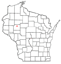
Location of Cleveland, Wisconsin
|
|
| Country | |
| State | |
| County | Chippewa |
| Area | |
| • Total | 56.3 sq mi (145.8 km2) |
| • Land | 54.0 sq mi (139.8 km2) |
| • Water | 2.3 sq mi (6.0 km2) |
| Elevation | 1,214 ft (370 m) |
| Population
(2010)
|
|
| • Total | 864 |
| • Density | 16/sq mi (6.2/km2) |
| Time zone | UTC-6 (Central (CST)) |
| • Summer (DST) | UTC-5 (CDT) |
| Area code(s) | 715 & 534 |
| FIPS code | 55-15350 |
| GNIS feature ID | 1582974 |
| PLSS township | Eastern 4 miles of T31N R8W, most of T31N R7W and bits of T31N R6W west of the Chippewa River |
Cleveland is a small town located in Chippewa County, Wisconsin, in the United States. According to a count in 2010, about 864 people lived there.
Where is Cleveland, Wisconsin?
Cleveland is in the north-central part of Chippewa County. The town is shaped like a rectangle. It is about 6 miles (10 km) from north to south and about 9 miles (14 km) from east to west.
The Chippewa River forms the eastern edge of the town. The city of Cornell is also next to Cleveland on its eastern side.
The United States Census Bureau says that Cleveland covers a total area of about 56.3 square miles (145.8 km2). Most of this area, about 54.0 square miles (139.8 km2), is land. The rest, about 2.3 square miles (6.0 km2), is water.
History of Cleveland
The land that would become Cleveland was first measured and mapped in the summer of 1847. This work was done by a team working for the U.S. government. They were surveying the area.
In September 1852, another team marked all the corners of the land sections. They walked through the forests and swamps, using tools like a chain and a compass to measure.
After their work, the surveyor wrote a description of the land. He said that the area had a large swamp with tamarack and cedar trees. He noted that the soil was mostly flat and good for farming in many places.
He also mentioned that the land had many pine, hemlock, and maple trees. The Chippewa River flowed through the area. He described it as having a fast current and high banks with many trees.
On March 28, 1885, the town was officially named Cleveland. It was named after Grover Cleveland, who was the President of the United States at that time.
Who Lives in Cleveland?
| Historical population | |||
|---|---|---|---|
| Census | Pop. | %± | |
| 1990 | 758 | — | |
| 2000 | 900 | 18.7% | |
| 2010 | 864 | −4.0% | |
| 2020 (est.) | 905 | 4.7% | |
In 2000, a count of the population, called a census, showed that 900 people lived in Cleveland. There were 313 households, which are groups of people living together. Out of these, 251 were families.
The population density was about 16.6 people for every square mile. Most of the people living in the town were White (98.78%). A small number of people were from other backgrounds.
About 42.8% of the households had children under 18 living with them. Most households (69.0%) were married couples living together. About 17.3% of all households were single people living alone.
The average household had about 2.88 people. The average family had about 3.22 people.
The population was spread out by age. About 30.6% of the people were under 18 years old. About 30.7% were between 25 and 44 years old. About 8.7% were 65 years or older. The average age in the town was 35 years.
See also
 In Spanish: Cleveland (condado de Chippewa, Wisconsin) para niños

