Cleveland, Minnesota facts for kids
Quick facts for kids
Cleveland, Minnesota
|
|
|---|---|
| Motto(s):
"Friendly People, Our Greatest Asset"
|
|

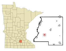
Location of Cleveland, Minnesota
|
|
| Country | United States |
| State | Minnesota |
| County | Le Sueur |
| Government | |
| • Type | Mayor - Council |
| Area | |
| • Total | 0.55 sq mi (1.42 km2) |
| • Land | 0.55 sq mi (1.42 km2) |
| • Water | 0.00 sq mi (0.00 km2) |
| Elevation | 1,043 ft (318 m) |
| Population
(2020)
|
|
| • Total | 747 |
| • Density | 1,365.63/sq mi (526.91/km2) |
| Time zone | UTC-6 (Central (CST)) |
| • Summer (DST) | UTC-5 (CDT) |
| ZIP code |
56017
|
| Area code(s) | 507 |
| FIPS code | 27-11872 |
| GNIS feature ID | 2393560 |
Cleveland is a small city in Le Sueur County, Minnesota, United States. It's known for its friendly community. In 2010, about 719 people lived here. By 2020, the population grew slightly to 747 residents.
Contents
History of Cleveland
Cleveland started as a small village in 1854. It officially became a city in 1904. The community was named after the larger city of Cleveland, Ohio.
Early Community Rules
When Cleveland was first founded, it had special rules. It was a "temperance town." This meant that people voted against allowing saloons or places that sold alcohol in the town.
County Seat Rivalry
From 1859, Cleveland had a big competition with a nearby town called Le Sueur. They both wanted to be the main town, or "county seat," for Le Sueur County. The county seat is where the county government offices are located.
This rivalry was quite intense. In 1875, some people from Cleveland even formed a group to try and take the county seat by force! They managed to bring the county seat documents from Le Sueur to Cleveland. However, after more than a year, the county seat was moved to Le Center, where it remains today.
Cleveland's Geography
Cleveland is a small city in terms of its land area. According to the United States Census Bureau, the city covers about 0.60 square miles (1.42 square kilometers). All of this area is land, with no large bodies of water inside the city limits.
Cleveland's Population
Cleveland is a small but growing community. Here's a look at how its population has changed over the years:
| Historical population | |||
|---|---|---|---|
| Census | Pop. | %± | |
| 1880 | 156 | — | |
| 1890 | 132 | −15.4% | |
| 1910 | 212 | — | |
| 1920 | 269 | 26.9% | |
| 1930 | 290 | 7.8% | |
| 1940 | 313 | 7.9% | |
| 1950 | 325 | 3.8% | |
| 1960 | 389 | 19.7% | |
| 1970 | 492 | 26.5% | |
| 1980 | 699 | 42.1% | |
| 1990 | 699 | 0.0% | |
| 2000 | 673 | −3.7% | |
| 2010 | 719 | 6.8% | |
| 2020 | 747 | 3.9% | |
Who Lives in Cleveland?
The most recent count was the 2020 Census. It showed that 747 people lived in Cleveland. The city had 273 households, which are groups of people living together.
Most people in Cleveland are White (about 91.83%). There are also smaller numbers of people from other racial backgrounds. About 3.61% of the population identified as Hispanic or Latino.
Many households (38.8%) had children under 18 living with them. The average household had about 2.92 people. The average family size was 3.47 people.
The median age in Cleveland was 32.3 years old. This means half the people were younger and half were older than 32.3. About 32.5% of the population was under 18.
Education in Cleveland
Cleveland has its own public school district, called Cleveland Public School District #391. This district includes Cleveland Elementary School and Cleveland Secondary School. These schools serve students from pre-kindergarten all the way up to twelfth grade.
The current Superintendent is Brian J. Phillips. The school district has a clear mission: "Inspire, Learn, Grow, Achieve - a community where students and relationships matter." This shows their focus on helping students learn and grow in a supportive environment.
Transportation in Cleveland
For getting around Cleveland and connecting to other areas, Minnesota State Highway 99 is the main road. It helps residents travel in and out of the community.
See also
 In Spanish: Cleveland (Minnesota) para niños
 | Leon Lynch |
 | Milton P. Webster |
 | Ferdinand Smith |


