Clew Bay facts for kids
Quick facts for kids Clew Bay |
|
|---|---|

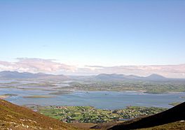
Overlooking Murrisk and Clew Bay
|
|
 |
|
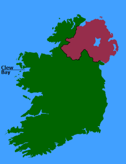
| Location | County Mayo |
| Coordinates | 53°50′N 9°48′W / 53.833°N 9.800°W |
| Native name | Cuan Mó Error {{native name checker}}: parameter value is malformed (help) |
| Etymology | English name: "bay of hurdles" Irish name: "Modh's harbour" |
| River sources | Bunowen river network, Owenmore river network, Newport river network, Srahmore river, Carrowbeg River, Moyour River, Owenglasbreen Stream, Owenwee River, Owennabrockagh river, Rossow river |
| Ocean/sea sources | Atlantic Ocean |
| Basin countries | Ireland |
| Islands | Clare Island |
| Settlements | Louisburgh, Lecanvey, Murrisk, Westport, Newport, Mulranny |
Clew Bay (Irish: Cuan Mó) is a beautiful natural bay located in County Mayo, Republic of Ireland. It's famous for having many small islands. These islands are actually the tops of hills called drumlins that were covered by the sea a long, long time ago. Clew Bay is a great example of this type of landscape in Ireland.
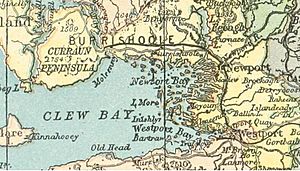
The bay is surrounded by stunning scenery. To the south, you can see Croagh Patrick, a famous mountain. The Nephin Range mountains are to the north. Clare Island sits at the entrance, like a guard to the bay. Along the shores, you'll find towns like Louisburgh, Westport, and Newport. From the southern part of the bay, you can even spot Bills Rocks between Clare Island and Achill.
Contents
Discovering Clew Bay's Past
Clew Bay has a long and interesting history. In ancient Irish times, it was known by names like Cuan Mod or Modlind. These names might have come from an old legend about a person named Modh.
Another old name for the bay was Cuan Umaill, which meant "harbour of Umhaill." This name changed over time in English to things like "Bay of the Owly" and "Bay of the Owles." The name Clew Bay itself first appeared on a map in 1714. It might come from an Irish word, cliath, which means "hurdle."
The Pirate Queen and Clew Bay
Clew Bay was very important to the O'Malley family during the Middle Ages. The most famous person linked to the bay is Grace O'Malley, also known as Granuaile. She was a powerful "Pirate Queen" who led her own fleet of ships. Grace O'Malley owned several castles around the bay, including ones on Clare Island and at Rockfleet.
Later, during the Irish Civil War in July 1922, Clew Bay played a role in history. About 400 soldiers landed here to take control of Westport and Castlebar from opposing forces.
Inishgort Lighthouse
You can find the Inishgort Lighthouse on Inishgort island. It stands about 5 kilometers (3 miles) from the town of Murrisk. Lighthouses like this help guide ships safely through the bay.
Fish Farming in the Bay
In recent years, there has been some discussion about fish farming in Clew Bay. One company, "The Organic Salmon Company," is based on Clare Island. Fish farming involves raising fish in enclosed areas in the sea.
Islands of Clew Bay
Clew Bay is famous for its many islands. One of these islands, Dorinish, was even bought by the famous musician John Lennon in 1967. There was also a sailing school on Collanmore Island where people could learn to sail.
There's a fun legend that says Clew Bay has 365 islands—one for every day of the year! This myth came from the huge number of small, rounded hills (drumlins) that stick out of the water at the eastern end of the bay. While there are many islands, the actual number is not quite 365.
Drumlin Islands and Rocks
The eastern part of Clew Bay has 141 named islands and smaller islets. These are mostly drumlins, which are small, oval-shaped hills formed by glaciers. When the sea level rose after the Ice Age, the lower parts of these drumlins were covered by water, leaving their tops as islands.
See also
 In Spanish: Bahía de Clew para niños
 | Janet Taylor Pickett |
 | Synthia Saint James |
 | Howardena Pindell |
 | Faith Ringgold |


