
Achill Island facts for kids
|
Native name:
Acaill, Oileán Acla
|
|
|---|---|

Topography of Achill
|
|

Achill
Location in Ireland
|
|
| Geography | |
| Location | Atlantic Ocean |
| Coordinates | 53°57′50″N 10°00′11″W / 53.96391°N 10.00303°W |
| Archipelago | Achill |
| Total islands | 3 (Achill,Innisbiggle and Achillbeg islands) |
| Major islands | Achill |
| Area | 36,572 acres (14,800 ha) |
| Coastline | 128 km (79.5 mi) |
| Highest elevation | 688 m (2,257 ft) |
| Highest point | Croaghaun |
| Administration | |
| Province | Connacht |
| County | Mayo |
| Barony | Burrishoole |
| Demographics | |
| Population | 2,569 (2011) |
| Pop. density | 17.3 /km2 (44.8 /sq mi) |
| Ethnic groups | Irish |
| Additional information | |
| Ireland's largest island | |
Achill Island (Irish: Acaill, Oileán Acla) is the biggest island in Ireland. It is located off the west coast of County Mayo. About 2,594 people live there. The island covers an area of 148 square kilometers (57 square miles).
Achill is connected to the mainland by the Michael Davitt Bridge. This bridge is between the villages of Gob an Choire (Achill Sound) and Poll Raithní (Polranny). The first bridge here was built in 1887. Other villages on the island include Keel, Dooagh, Dumha Éige (Dooega), Dún Ibhir (Dooniver), and Dugort.
Most of Achill Island (87%) is covered in peat bog. The area of Achill includes Achill Island itself, plus smaller islands like Achillbeg and Inishbiggle. It also includes the Corraun Peninsula.
About half of the island, including Achill Sound and Bunacurry, is part of the Gaeltacht. This is a region where the traditional Irish language is spoken. However, most people on the island speak English every day.

Contents
Achill Island's Past
People believe that around 4000 BC, at the end of the Neolithic period, about 500 to 1,000 people lived on Achill. The island was mostly forest back then. Early people started growing crops, which led to more settlements.
During the Iron Age, more people settled on the island. Small forts along the coast show that these were times of conflict. You can still see ancient tombs and forts at Slievemore, along the Atlantic Drive, and on Achillbeg.
Who Ruled Achill?
Achill Island is in the area called Burrishoole. This region was once part of ancient Umaill. The O'Malleys were the main leaders of Umhall. Records show them fighting off Viking attacks in 814 AD.
Later, in 1235 AD, the Anglo-Normans took over Connacht. The Butlers and then the de Burgos ruled Umhall. The Butler family controlled Burrishoole until the late 1300s.
People Moving to Achill
In the 1600s and 1700s, many people moved to Achill from other parts of Ireland. They came from places like Ulster because of political and religious problems. For a while, two different dialects of Irish were spoken on Achill. This is why some places had two names on maps from 1824. Today, Achill Irish still has many words from Ulster Irish.
Important Places and Events
Grace O'Malley's Castle
Carrickkildavnet Castle is a tower house from the 1400s. It is linked to the O'Malley family, who once ruled Achill. Grace O' Malley, also known as Granuaile, was born around 1530 on Clare Island. Her father was a chieftain. The O'Malleys were a strong seafaring family. Grace became a brave leader and was known as a sea captain and pirate. She is said to have met Queen Elizabeth I in 1593. Grace O'Malley died around 1603. She is buried on Clare Island.
The Achill Mission
.jpg)
One famous historical site is the Achill Mission, or 'the Colony', in Dugort. In 1831, Reverend Edward Nangle of the Church of Ireland started a mission there. He aimed to spread his religion. The Mission had schools, homes, an orphanage, a hospital, and a guesthouse.
People had mixed feelings about the Colony. During the Great Famine, some accused Edward Nangle of trying to change people's religion by offering them food. For nearly 40 years, Nangle published a newspaper called the Achill Missionary Herald. He expanded his mission to Mweelin, building more schools and churches. Edward's wife, Eliza, died in 1852 and is buried in North Achill. The Achill Mission slowly declined after Nangle left. It finally closed in the 1880s.
The Railway Comes to Achill
In 1894, a railway line was extended to Achill Sound. The old railway station is now a hostel. The train helped Achill a lot. But it also seemed to fulfill an old prophecy. Brian Rua U'Cearbhain had predicted that 'carts on iron wheels' would carry bodies into Achill on their first and last journeys.
In 1894, the first train to Achill carried the bodies of 32 young people. They had drowned in Clew Bay while going to Scotland for potato picking. This was the "Clew Bay Drowning" tragedy.
The "Kirkintilloch Fire" in 1937 almost fulfilled the second part of the prophecy. Ten victims' bodies were brought to Achill by train. This was not literally the last train, but the railway closed just two weeks later. These people had died in a fire in a temporary home in Kirkintilloch, Scotland. Many people from Achill went to Scotland to pick potatoes in those days.

Kildamhnait Church
Kildamhnait, on Achill's southeast coast, is named after St. Damhnait (or Dymphna). She founded a church there in the 600s. There is also a holy well near the graveyard. The current church was built in the 1700s. The graveyard holds memorials to the victims of the Kirkintilloch Fire (1937) and the Clew Bay Drowning (1894).
The Monastery
In 1852, Dr. John McHale bought land in Bunnacurry. A Franciscan Monastery was built there. For many years, it provided education for local children. The building of the monastery led to a conflict. It was between the followers of the Achill Mission and those building the monastery. This fight is known as the Battle of the Stones in local stories.
Brother Paul Carney was a notable monk at the monastery. He lived there for almost 30 years. He wrote a book about James Lynchehaun. Lynchehaun became famous after being found guilty of an attack on the Valley House in 1894. Brother Paul also wrote about his church fundraising trips across the US. The ruins of this monastery can still be seen in Bunnacurry today.
The Valley House
The historic Valley House is in The Valley, near Dugort. It is in the northeast of Achill Island. The building today stands where a hunting lodge was built in the 1800s. It became famous because of an event in 1894. The owner, Agnes McDonnell, was badly beaten. The house was set on fire. A local man, James Lynchehaun, was accused.
Lynchehaun worked for McDonnell as her land agent. But they had a disagreement, and he was fired. He refused to leave his home on her land. A long legal fight followed. In the 1890s, land ownership in Ireland was a big political issue. Lynchehaun claimed his actions were political. He escaped and fled to the United States. He avoided being sent back to Ireland to face charges.
Agnes McDonnell suffered terrible injuries but survived. She lived for another 23 years, dying in 1923. Lynchehaun is said to have returned to Achill twice, once in disguise. He died in Scotland in 1937. The Valley House is now a Hostel and Bar.


The Deserted Village
Near Dugort, at the base of Slievemore mountain, is the Deserted Village. There are about 80 ruined houses there. These houses were built without cement or mortar. Each house had only one room. This room was used for everything: cooking, living, sleeping, and even as a stable.
If you look at the fields around the Deserted Village, you can see tracks called 'lazy beds'. This was how crops like potatoes were grown. In Achill, farmers used a system called 'Rundale'. Land around a village was rented from a landlord. Then, all the villagers shared this land to graze their animals. Each family also had small pieces of land to grow crops.
People lived in the village for many years. But in 1845, the Great Famine hit Achill, like the rest of Ireland. Most families moved to the nearby village of Dooagh, which is by the sea. Some others moved away from Ireland. Living by the sea meant they could find fish and shellfish for food. The village was completely left empty, which is why it's called the 'Deserted Village'.
No one has lived in these houses since the Famine. However, the families who moved to Dooagh still used the village as a 'booley village'. This meant that in summer, teenagers would take cattle to graze on the hillside. They would stay in the houses of the Deserted Village. This tradition continued until the 1940s. Boolying also happened in other parts of Achill, like Annagh and Curraun.
At Ailt, Kildownet, you can find another deserted village. This village was abandoned in 1855. The landlord evicted the tenants to use the land for cattle. The tenants had to rent land in Currane, Dooega, and Slievemore. Others moved to America.
Exploring Achill's Past: Archaeology

The Achill Archaeological Field School is in Dooagh. It helps with many archaeological studies on the island. It started in 1991. It is a training school for students of archaeology and anthropology. Thousands of students from 21 countries have come to Achill. They study and help with excavations.
The school studies the ancient and historical landscape at Slievemore. They dig at several sites within the deserted village of Slievemore. Slievemore has many ancient sites. They cover 5,000 years, from the Stone Age to more recent times. Recent studies suggest the village was lived in all year round in the 1800s. But in the early 1900s, it was a 'booley village'.
A booley village is only lived in for part of the year. On Achill, it was a place to live while taking care of animals in summer. Some people from Dooagh and Pollagh would move to Slievemore in the summer. Then they would go back to Dooagh in the autumn.
From 2004 to 2006, the Achill Island Maritime Archaeology Project studied the island's sea history. They recorded a 19th-century fishing station, an ice house, and boat house ruins. They also found old anchors, traditional boats, and the remains of four historic shipwrecks.
Other Interesting Places to Visit


The cliffs of Croaghaun are on the west side of the island. They are the third highest sea cliffs in Europe. But you cannot reach them by road. Near the very west end of Achill, called Achill Head, is Keem Bay. Keel Beach is very popular with tourists and locals for surfing.
South of Keem beach is Moytoge Head. It is a rounded headland that drops steeply to the ocean. An old British observation post is still there. It was built during World War I to stop the Germans from bringing weapons to the Irish Republican Army. During World War II, the Irish Defence Forces rebuilt this post. It was a Look Out Post for watching the coast from 1939 to 1945.
The mountain of Slievemore, at 672 meters (2,205 feet), rises dramatically in the north. The Atlantic Drive, along the south and west of the island, has amazing views. On the slopes of Slievemore, there is an abandoned village (the "Deserted Village"). This village is thought to be a leftover from the Great Hunger of 1845–1849.
Just west of the deserted village is an old Martello tower. The British also built this to warn of any possible French invasion during the Napoleonic Wars. The area also has a Neolithic tomb that is about 5,000 years old.
Achillbeg (Acaill Beag, meaning Little Achill) is a small island near Achill's southern tip. Its people were moved to Achill in the 1960s. A plaque for Johnny Kilbane is on Achillbeg. It celebrates 100 years since his first championship win.
The villages of Dooniver and Askill have beautiful scenery. The cycle route there is popular with tourists.
Caisleán Ghráinne, also known as Kildownet Castle, is a small tower house. It was built in the early 1400s. It is in Cloughmore, on the south of Achill Island. It is known for its links to Grace O'Malley.
Achill's Economy
Achill's economy mostly depends on tourism. In the past, money sent home by Achill people working abroad helped families stay on the island. This was especially true in the 1800s and 1900s. Since Ireland's "Celtic Tiger" economy, fewer people have had to leave Achill for work.
Agriculture is a small part of the economy. Most of the island is bog, so farming is limited. It is mainly for sheep farming. In the past, fishing was very important. But now, it is a small part of the economy. The island was once known for shark fishing, especially for basking sharks. Their liver oil was valuable.
Tourism grew a lot in the 1960s and 1970s. Before that, life on the island was very hard. Even though many visitors come each year, some feel that tourism in Achill has been slowly going down. Today, the biggest employers on Achill are two hotels. In late 2009, Ireland's only turbot fish farm opened in the Bunnacurry Business Park.
Religion on Achill
Most people on Achill are either Roman Catholic or Anglican (Church of Ireland).
Here are some of the churches on the island:
- Catholic Churches:
- Bunnacurry Church (Saint Josephs)
- The Valley Church (open for special events)
- Dookinella Church
- Currane Church
- Pollagh Church
- Derreens Church
- Dooega Church
- Belfarsed Church
- Achill Sound Church
- Church of Ireland Churches:
- Dugort Church (St. Thomas's church)
- Innisbiggle Island church
- Other:
- House of Prayer, Achill
Learning on Achill
In the past, "hedge schools" existed in most Achill villages. These were informal schools. A university was started by the missions in Mweelin. Today, there used to be two secondary schools: Mc Hale College and Scoil Damhnait. But in August 2011, they joined together to form Coláiste Pobail Acla.
For primary education, there are eight National Schools. These include Bullsmouth NS, Valley NS, Bunnacurry NS, Dookinella NS, Dooagh NS, Saula NS, Achill Sound NS, and Tonragee NS. Some National Schools that have closed are Dooega NS, Crumpaun NS, Ashleam NS, and Currane NS.
Getting Around Achill
- The Achill railway station opened in 1895 and closed in 1937.
- The Great Western Greenway is a greenway for walking and cycling. It follows the old railway line from Westport to Achill. It goes through Newport and Mulranny. This greenway has been very successful in bringing visitors to Achill.
- Bus Éireann route 440 travels daily to Westport and beyond from the island's villages.
- Bus Éireann also provides transport for secondary school children in the area.
- There are many Taxicab and Hackney carriage services on the island.
Food on Achill
Achill is a popular place for tourists. It has many bars, cafes, and restaurants that serve all kinds of food. Because the island is on the Atlantic Ocean, seafood is a special dish. Common seafood includes lobster, mussels, salmon, trout, and winkles.
Achill also has many sheep. So, Achill lamb is a very popular meal. There are also many cows, which provide excellent beef.
Sports and Activities
Achill has a Gaelic football club. It plays in the junior championship and division 1E of the Mayo League. There is also Achill Rovers, which plays in the Mayo Association Football League.
The island has a 9-hole links golf course. You can do outdoor activities through the Achill Outdoor Education Centre. Achill Island's wild landscape and the ocean offer many places for adventure activities. These include surfing, kite-surfing, and sea kayaking. Fishing and watersports are also popular.
Sailing races with a local boat type, the Achill Yawl, have been popular since the 1800s. Today, most yawls are changed to go faster. Scuba divers sometimes visit the island's waters and underwater sites. However, Achill's weather can be unpredictable.
Population of Achill
In 2016, the population was 2,594. About 5.2% of people said they spoke Irish daily outside of school. The island's population has gone down from around 6,000 before the Great Hunger.
Population Changes Over Time
The table below shows data on Achill Island's population. It comes from Discover the Islands of Ireland (Alex Ritsema, Collins Press, 1999) and the census of Ireland.
| Historical population | |||||||||||||||||||||||||||||||||||||||||||||||||||||||||||||||||||||||||||||||||||
|---|---|---|---|---|---|---|---|---|---|---|---|---|---|---|---|---|---|---|---|---|---|---|---|---|---|---|---|---|---|---|---|---|---|---|---|---|---|---|---|---|---|---|---|---|---|---|---|---|---|---|---|---|---|---|---|---|---|---|---|---|---|---|---|---|---|---|---|---|---|---|---|---|---|---|---|---|---|---|---|---|---|---|---|
|
|
|
|||||||||||||||||||||||||||||||||||||||||||||||||||||||||||||||||||||||||||||||||
| Source: | |||||||||||||||||||||||||||||||||||||||||||||||||||||||||||||||||||||||||||||||||||
Achill's Architecture
Because of the harsh weather, few houses built before the 1900s are still lived in. However, there are many abandoned stone buildings from the 1800s.


The most famous of these old buildings are the ruins in the "Deserted Village" near the graveyard at Slievemore. Even these houses were quite comfortable for their time. As recently as 100 years ago, some people still lived in "Beehive" style houses. These were small, round, one-room homes with a hole in the ceiling for smoke.
Many of the oldest lived-in cottages were built with help from the Congested Districts Board for Ireland. This group was set up around 1900 to improve life in small villages. Most homes in Achill at the time were very small and crowded. The Board helped pay for new, larger homes outside the old villages.
Some of the newer buildings (from 1980 onwards) do not fit as well into the landscape. Many holiday homes have been built. But some of these are in beautiful areas and block traditional views. They also sit empty for most of the year.
Images for kids
-
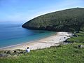
Keem Bay
See also
 In Spanish: Isla Achill para niños
