Slievemore facts for kids
Quick facts for kids Slievemore |
|
|---|---|
| Sliabh Mór | |

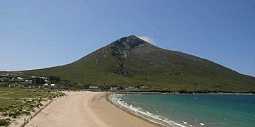
Slievemore from Dugort
|
|
| Highest point | |
| Elevation | 671 m (2,201 ft) |
| Prominence | 582 m (1,909 ft) |
| Parent peak | Croaghaun |
| Listing | Marilyn, Hewitt |
| Naming | |
| English translation | big mountain |
| Language of name | Irish |
| Geography | |
|
Lua error in Module:Location_map at line 420: attempt to index field 'wikibase' (a nil value).
|
|
| Location | Mayo, Republic of Ireland |
| Parent range | Achill Island |
| OSI/OSNI grid | F650086 |
| Topo map | OSi Discovery 30 |
Slievemore (which means Big Mountain in Irish) is a really tall mountain on Achill Island in County Mayo, Ireland. It's the second highest peak there, right after Croaghaun. Slievemore stands at 671 meters (about 2,201 feet) high!
Exploring Slievemore's Past
Slievemore is a super interesting place for history detectives! It's full of ancient sites and monuments. Some of these are over 5,000 years old! They date from the Neolithic period (that's the New Stone Age) all the way up to the 1850s.
The Achill Archaeology Centre
The Achill Archaeological Field School is based at the Achill Archaeology Centre. This school started in 1991. It teaches students how to be archaeologists and anthropologists.
- Archaeology is the study of human history and prehistory. People learn about the past by digging up old things.
- Anthropology is the study of human societies and cultures.
The Deserted Village Project
The school works on a special project called the Deserted Village Project. This project began in 1991. Its goal is to explore and map all the old sites and monuments at Slievemore.
They are especially interested in the "Deserted Village" of Slievemore. This village has many old buildings and remains. By studying these, archaeologists learn how people lived long ago on Achill Island. They dig carefully to find clues about the past.
 | Valerie Thomas |
 | Frederick McKinley Jones |
 | George Edward Alcorn Jr. |
 | Thomas Mensah |

