Coclé Province facts for kids
Quick facts for kids
Coclé Province
Provincia de Coclé
|
|||
|---|---|---|---|

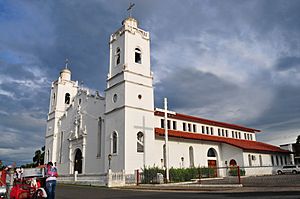
Saint John the Baptist cathedral, Penonomé
|
|||
|
|||

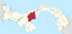
Coclé, in red, in Panama
|
|||
| Country | |||
| Founded | 1985 | ||
| Capital | Penonomé | ||
| Districts | Aguadulce, Antón, La Pintada, Natá, Olá, Penonomé | ||
| Area | |||
| • Total | 4,946.6 km2 (1,909.9 sq mi) | ||
| Population
(2010)
|
|||
| • Total | 233,708 | ||
| • Density | 47.2462/km2 (122.3671/sq mi) | ||
| Demonym(s) | Coclesano | ||
| Time zone | UTC+1 (Eastern Time) | ||
| • Summer (DST) | UTC-5 (CEST) | ||
| ISO 3166 code | PA-2 | ||
Coclé is a province in the country of Panama. It's located in the middle of Panama, right on the southern coast next to the Pacific Ocean. The main city and capital of Coclé is Penonomé.
Contents
History of Coclé Province
Coclé became a special area called a 'Department' in 1855. This happened when Justo de Arosemena was president. Later, on October 20, 1985, its name was changed to 'province'.
Where is Coclé Located?
Coclé province shares its borders with several other areas. To the north, it's next to the Colón province. To the east, you'll find the Panamá Oeste province. The Pacific Ocean and the Herrera province are to the south. Finally, the Veraguas province is to the west.
 |
Colón province |  |
||
| Veraguas province | Panamá Oeste province | |||
| Herrera province | Gulf of Parita (Pacific Ocean) |
Geography of Coclé
Coclé province covers an area of about 4,946.6 square kilometers (1,909.9 square miles).
The Cordillera Central, which is a large mountain range, runs through the northern part of the province. This mountain range divides the province into two main areas where rivers flow. Rivers on the north side of the mountains flow towards the Caribbean Sea. Rivers on the south side flow towards the Pacific Ocean.
In the southern part of the province, there is a large flat area called a plain. This plain stretches all the way to the Pacific coast.
Nature Parks in Coclé
In the northeast part of Coclé, there is a special place called the Parque Nacional General de División Omar Torrijos Herrera. This is a national park where nature is protected.
People of Coclé
The people who live in Coclé province are called Coclesanos. If you're talking about women, you'd call them Coclesanas.
In 2010, the Coclé province had a population of 233,708 people. This means there were about 47.2 people living in each square kilometer.
How the Population of Coclé Province Has Grown

How Coclé is Divided
Coclé province is split into six main areas called districts. These districts are then further divided into 44 smaller parts called corregimientos.
| Districts | Capital | Area (km²) |
Population (2010) |
Density (inh./km²) |
Corregimientos |
|---|---|---|---|---|---|
| Aguadulce | San Juan Bautista de Aguadulce | 469.3 | 43,360 | 92.4 | San Juan Bautista de Aguadulce, El Cristo, El Roble, Pocrí, Barrios Unidos |
| Antón | Antón | 747.8 | 54,632 | 73.1 | Antón, Cabuya, El Chirú, El Retiro, El Valle, Juan Díaz, Río Hato, San Juan de Dios, Santa Rita, Caballero |
| La Pintada | La Pintada | 1,030.0 | 25,639 | 24.9 | La Pintada, El Harino, El Potrero, Llano Grande, Piedras Gordas, Las Lomas, Llano Norte |
| Natá | Natá de los Caballeros | 605.2 | 18,465 | 30.5 | Natá, Capellanía, El Caño, Guzmán, Las Huacas, Toza |
| Olá | Olá | 385.7 | 5,875 | 15.2 | Olá, El Copé, El Palmar, El Picacho, La Pava |
| Penonomé | Penonomé | 1,708.6 | 85,737 | 50.2 | Penonomé, Cañaveral, Coclé, Chiguirí Arriba, El Coco, Pajonal, Río Grande, Río Indio, Toabré, Tulú, El Valle de San Miguel |
Economy and Tourism
Coclé is mostly a farming area. Farmers here grow a lot of sugar and tomatoes. The province also has many famous beaches, like Santa Clara, Farallon, and Rio Hato. Because of these beautiful beaches, more and more tourists have been visiting Coclé in recent years.
Images for kids
See also
 In Spanish: Provincia de Coclé para niños
 | Emma Amos |
 | Edward Mitchell Bannister |
 | Larry D. Alexander |
 | Ernie Barnes |


