Cody Scarp facts for kids
The Cody Scarp is a cool natural feature in north and central Florida, USA. It's like an old, long-lasting cliff or slope that was formed a very long time ago. Imagine it as a leftover from ancient shorelines from the early Ice Ages, about 1.8 million to 10,000 years ago. This happened during warmer times between ice ages. The Cody Scarp usually has a gentle slope, from 5% to 12%.
Contents
Where is the Cody Scarp?
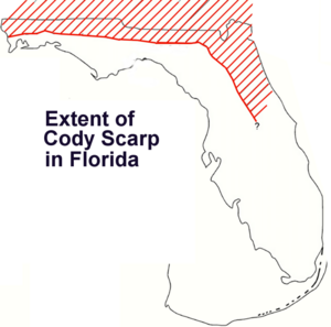
The Cody Scarp stretches across Florida. It goes from just east of the Apalachicola River all the way to Alachua County, Florida. It acts like a natural border. It separates two main areas of Florida: the Gulf Coastal Lowlands and the Northern Highlands.
Gulf Coastal Lowlands
The Gulf Coastal Lowlands have a thin layer of soil. Underneath this soil, there is a lot of limestone.
Northern Highlands
The Northern Highlands are different. They are made up of flat, raised areas called plateaus. These plateaus are mostly sand, clay, and carbonate rock. The Cody Scarp rises about 30 meters (100 feet) from the lowlands to these highlands.
Karst Landscapes
Both the Cody Scarp area and the Gulf Coastal Lowlands are what we call karst landscapes. This means they have many special features. You can find lots of sinkholes, natural springs, and even underground streams here.
How High is the Scarp?
The scarp is highest in Leon County, Florida. Here, it is about 42.6 to 45.7 meters (140 to 150 feet) above sea level. It's a leftover from two ancient shorelines from the Ice Ages. These are known as the Okefenokee Terrace and the Wicomico Terrace.
In Jefferson County, Florida, to the east, the scarp is part of the Wicomico Terrace. It is about 12 to 14 meters (40 to 45 feet) above mean sea level.
What Does the Scarp Separate?
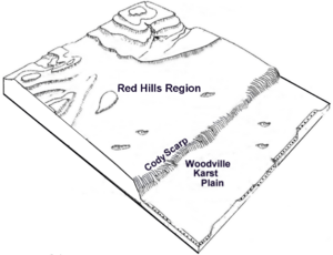
The Cody Scarp separates different types of land. To the north, it separates the Hawthorn Group of sandy clays and silty sands. This area is part of the Red Hills Region in north Florida and southwest Georgia.
To the south, the scarp separates the fine-grained limestones of the Gulf Coastal Lowlands. There's a big change in height here. The Red Hills can be as high as 70 meters (230 feet) above sea level. But within about 24 kilometers (15 miles), the land drops to the Woodville Karst Plain. This plain is only 15 to 24 meters (50 to 80 feet) high.
Woodville Karst Plain
On the Woodville Karst Plain, the Suwannee Limestone is very close to the surface. In many places, you can even see it. This limestone is part of the Floridan Aquifer, which is a huge underground water source. This area is very important for refilling the aquifer. It's also where the aquifer is most easily polluted by things on the land. This plain also has a lot of sinkholes.
Cody Scarp in Alachua County
In Alachua County, Florida, this westward-facing scarp is between a higher area to the east and a karst plain to the west. Here, the land can be up to 57.9 meters (190 feet) above sea level. The Cody Scarp even runs right through the city of Gainesville, Florida.
 | William Lucy |
 | Charles Hayes |
 | Cleveland Robinson |


