Coleman, Leicester facts for kids
Quick facts for kids Coleman |
|
|---|---|
 |
|
| Population | 12,099 |
| Unitary authority | |
| Ceremonial county | |
| Region | |
| Country | England |
| Sovereign state | United Kingdom |
| Post town | LEICESTER |
| Postcode district | LE5 |
| Dialling code | 0116 |
| Police | Leicestershire |
| Fire | Leicestershire |
| Ambulance | East Midlands |
| EU Parliament | East Midlands |
| UK Parliament |
|
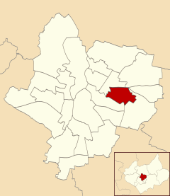
Coleman was a special area, like a neighborhood, in the city of Leicester, England. It used to be an "electoral ward." This means it was a specific area used for voting and local government. Coleman included two parts: Crown Hills and North Evington. In 2015, this area changed. North Evington became its own ward, taking Coleman's place.
Where Was Coleman?
Coleman was located in Leicester, England. It shared its borders with other wards, which are like neighboring districts. To the west and north, it was next to Charnwood. To the northeast, it bordered Humberstone & Hamilton. Evington was to the east, and Spinney Hills was to the south.
How Coleman Grew Over Time
North Evington, a part of Coleman, was originally separate from the main village of Evington. Over time, the empty spaces between them were filled with buildings. This area became part of Highfields, a working-class district. Many Victorian-style houses were built there for workers.
The area was planned and built as a suburb, which is a residential area outside a city center. This work was done by Arthur Wakerley, starting in the 1880s. By the time of the First World War, the entire area was developed. Coleman was originally outside the main city boundary. However, in 1892, it officially became part of the city of Leicester.
Learning in Coleman
A local secondary school, Crown Hills Community College, is located in the Crown Hills area. This school provides education for students in the community.
 | Shirley Ann Jackson |
 | Garett Morgan |
 | J. Ernest Wilkins Jr. |
 | Elijah McCoy |

