Columbia City, Oregon facts for kids
Quick facts for kids
Columbia City, Oregon
|
|
|---|---|

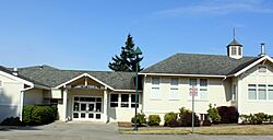
Local elementary school
|
|
| Motto(s):
"City of Beauty and Livability"
|
|

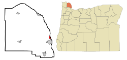
Location in Oregon
|
|
| Country | United States |
| State | Oregon |
| County | Columbia |
| Incorporated | 1926 |
| Area | |
| • Total | 1.16 sq mi (3.00 km2) |
| • Land | 0.79 sq mi (2.03 km2) |
| • Water | 0.37 sq mi (0.97 km2) |
| Elevation | 75 ft (23 m) |
| Population
(2020)
|
|
| • Total | 1,949 |
| • Density | 2,482.80/sq mi (959.21/km2) |
| Time zone | UTC-8 (Pacific) |
| • Summer (DST) | UTC-7 (Pacific) |
| ZIP code |
97018
|
| Area code(s) | 503 |
| FIPS code | 41-14750 |
| GNIS feature ID | 2410201 |
| Website | www.columbia-city.org |
Columbia City is a small city located in Columbia County, Oregon, in the United States. It gets its name from its spot right on the Columbia River. In 2010, about 1,946 people lived there.
Contents
History of Columbia City
Columbia City was started in 1867 by two brothers, Jacob and Joseph Caples. They hoped it would become a major stop for a new railroad line. However, the city of Portland ended up being the main railroad hub instead.
In 1871, Columbia City got its own post office. Later, in 1902, a special railroad called the Columbia and Nehalem Valley Railroad was built. It was used to transport wood from the forests near Yankton.
During World War I, Columbia City played an important role. A company called Sommartson Shipbuilding Co. built ships there to help with the war effort. The city was a good place for this because the river channel was very close to the shore. However, when the war ended, the contracts for building ships were cancelled.
Today, Columbia City is a quiet town that serves as a nearby community for St. Helens.
Geography and Climate
Columbia City covers a total area of about 1.15 square miles (3.00 square kilometers). Most of this area, about 0.77 square miles (2.03 square kilometers), is land. The rest, about 0.38 square miles (0.97 square kilometers), is water.
What is the Climate Like?
Columbia City has a type of weather called a warm-summer Mediterranean climate. This means that the summers are warm but not too hot, and they are usually dry. The average monthly temperatures do not go above 71.6 degrees Fahrenheit (22 degrees Celsius).
Population of Columbia City
| Historical population | |||
|---|---|---|---|
| Census | Pop. | %± | |
| 1930 | 310 | — | |
| 1940 | 327 | 5.5% | |
| 1950 | 405 | 23.9% | |
| 1960 | 423 | 4.4% | |
| 1970 | 537 | 27.0% | |
| 1980 | 678 | 26.3% | |
| 1990 | 1,003 | 47.9% | |
| 2000 | 1,571 | 56.6% | |
| 2010 | 1,946 | 23.9% | |
| 2020 | 1,949 | 0.2% | |
| U.S. Decennial Census | |||
In 2010, there were 1,946 people living in Columbia City. These people lived in 787 homes, and 601 of these were families. The city had about 2,527 people per square mile (976 people per square kilometer).
Most of the people living in Columbia City were White (94.6%). There were also smaller groups of people from other backgrounds, including Native American, Asian, and people of Hispanic or Latino heritage.
The average age of people in Columbia City was 48.4 years old.
- About 18.6% of residents were under 18 years old.
- About 6.7% were between 18 and 24 years old.
- About 20.4% were between 25 and 44 years old.
- About 36% were between 45 and 64 years old.
- About 18.4% were 65 years old or older.
The city had slightly more females (51.2%) than males (48.8%).
See also

- In Spanish: Columbia City (Oregón) para niños
 | Jessica Watkins |
 | Robert Henry Lawrence Jr. |
 | Mae Jemison |
 | Sian Proctor |
 | Guion Bluford |

