Conklin, New York facts for kids
Quick facts for kids
Conklin, New York
|
|
|---|---|

“The Castle”
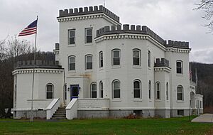
Alpheus Corby house, which is also the Town Hall for Conklin, New York |
|

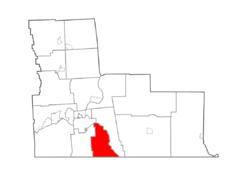
Map highlighting Conklin's location within Broome County.
|
|
| Country | United States |
| State | New York |
| County | Broome |
| Government | |
| • Type | Town Council |
| Area | |
| • Total | 24.89 sq mi (64.46 km2) |
| • Land | 24.39 sq mi (63.16 km2) |
| • Water | 0.50 sq mi (1.31 km2) |
| Elevation | 1,165 ft (355 m) |
| Population
(2020)
|
|
| • Total | 5,008 |
| • Density | 201.21/sq mi (77.692/km2) |
| Time zone | UTC−5 (Eastern (EST)) |
| • Summer (DST) | UTC−4 (EDT) |
| ZIP Code |
13748
|
| Area code(s) | 607 |
| FIPS code | 36-007-17772 |
| GNIS feature ID | 0978861 |
Conklin is a town in Broome County, New York, United States. Per the 2020 census, the population was 5,008.
The town is on the south border of the county, southeast of Binghamton.
Contents
History
The area was first settled around 1788. The Town of Conklin was established in 1824 from the town of Chenango by Nicholas Conklin (1782–1858). The town exchanged territories with adjacent towns before establishing its modern boundaries. In 1831, part of Conklin was used to form the town of Windsor, but Conklin received territory from Windsor in 1851. Another part of Conklin was used in 1859 to form the town of Kirkwood.
Alpheus Corby, a Conklin resident, built a castle-like structure as his home in 1900. The building is the current town hall.
In June 2006, the town was devastated by a massive flood that isolated the center of the town and required hundreds of people to be airlifted to safety. The flood destroyed hundreds of homes and businesses and caused tens of millions of dollars in damage.
The Conklin Town Hall was listed on the National Register of Historic Places in 2006.
The town experienced another major flood in September 2011 as a result of Tropical Storm Lee.
Geography
According to the United States Census Bureau, the town has a total area of 24.9 square miles (64.5 km2), of which 24.4 square miles (63.2 km2) is land and 0.50 square miles (1.3 km2), or 2.02%, is water.
The southern town line is the border of Susquehanna County in Pennsylvania. The eastern town line is marked by the Susquehanna River. Snake Creek, a tributary of the Susquehanna, was the site of early town settlement.
New York State Route 7 splits off New York State Route 7A in the southeast corner of the town by Corbettsville.
Communities and locations in Conklin
- Corbettsville – A hamlet on NY-7 in the southern part of the town.
- Conklin – The hamlet of Conklin by the Susquehanna River on NY-7. Access to Interstate 81's Exit 1 is across the Susquehanna via the Conklin-Kirkwood Bridge.
- Conklin Forks – A hamlet in the western part of the town at the junction of County Roads 8 and 141.
- Conklin Station – A hamlet north of Corbettsville on NY-7. It was previously called "Milburn."
- Conklin Center – A hamlet north of Conklin village on NY-7.
Demographics
| Historical population | |||
|---|---|---|---|
| Census | Pop. | %± | |
| 1830 | 908 | — | |
| 1840 | 1,475 | 62.4% | |
| 1850 | 2,232 | 51.3% | |
| 1860 | 1,146 | −48.7% | |
| 1870 | 1,440 | 25.7% | |
| 1880 | 1,420 | −1.4% | |
| 1890 | 1,033 | −27.3% | |
| 1900 | 946 | −8.4% | |
| 1910 | 850 | −10.1% | |
| 1920 | 796 | −6.4% | |
| 1930 | 1,332 | 67.3% | |
| 1940 | 2,156 | 61.9% | |
| 1950 | 2,872 | 33.2% | |
| 1960 | 4,347 | 51.4% | |
| 1970 | 5,399 | 24.2% | |
| 1980 | 6,204 | 14.9% | |
| 1990 | 6,265 | 1.0% | |
| 2000 | 5,940 | −5.2% | |
| 2010 | 5,441 | −8.4% | |
| 2020 | 5,008 | −8.0% | |
| U.S. Decennial Census 2010 2020 |
|||
2020 census
| Race / Ethnicity | Pop 2010 | Pop 2020 | % 2010 | % 2020 |
|---|---|---|---|---|
| White alone (NH) | 5,218 | 4,458 | 95.90% | 89.02% |
| Black or African American alone (NH) | 53 | 48 | 0.97% | 0.96% |
| Native American or Alaska Native alone (NH) | 8 | 10 | 0.15% | 0.20% |
| Asian alone (NH) | 16 | 37 | 0.29% | 0.74% |
| Pacific Islander alone (NH) | 0 | 0 | 0.00% | 0.00% |
| Some Other Race alone (NH) | 3 | 16 | 0.06% | 0.32% |
| Mixed Race/Multi-Racial (NH) | 67 | 310 | 1.23% | 6.19% |
| Hispanic or Latino (any race) | 76 | 129 | 1.40% | 2.58% |
| Total | 5,441 | 5,008 | 100.00% | 100.00% |
Note: the US Census treats Hispanic/Latino as an ethnic category. This table excludes Latinos from the racial categories and assigns them to a separate category. Hispanics/Latinos can be of any race.
Notable people
- Amos J. Cummings, United States Representative and Medal of Honor recipient
- Charles E. Fuller, member of the New York State Assembly
- Jerome Anthony Watrous, writer, military officer, legislator
- Jim Whitney, professional baseball player
See also
 In Spanish: Conklin (Nueva York) para niños


