Conway (CDP), New Hampshire facts for kids
Quick facts for kids
Conway, New Hampshire
|
|
|---|---|

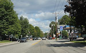
Conway on NH 16
|
|
| Country | United States |
| State | New Hampshire |
| County | Carroll |
| Town | Conway |
| Area | |
| • Total | 7.42 sq mi (19.22 km2) |
| • Land | 7.05 sq mi (18.25 km2) |
| • Water | 0.38 sq mi (0.97 km2) |
| Elevation | 459 ft (140 m) |
| Population
(2020)
|
|
| • Total | 3,576 |
| • Density | 507.52/sq mi (195.94/km2) |
| Time zone | UTC-5 (Eastern (EST)) |
| • Summer (DST) | UTC-4 (EDT) |
| ZIP code |
03818
|
| Area code(s) | 603 |
| FIPS code | 33-14580 |
| GNIS feature ID | 0871721 |
Conway is a special kind of community called a census-designated place (CDP) in New Hampshire. It's the main village in the larger town of Conway, located in Carroll County. In 2020, about 3,576 people lived here. It is the most populous community in the town of Conway, even bigger than North Conway.
Geography of Conway
Conway covers about 19.2 square kilometers (about 7.4 square miles). Most of this area is land, with a small part (about 1 square kilometer or 0.38 square miles) being water.
The village is in the southwestern part of the town of Conway. It is where three rivers meet: the Saco River, the Swift River, and Pequawket Brook. Conway is next to the town of Albany to the west and Madison to the south. North Conway is just to its north. Several important roads meet in the center of Conway. These include New Hampshire Route 16, Route 113, and Route 153. Also, Route 112, known as the Kancamagus Highway, starts in the western part of the village.
People of Conway
Conway has grown over the years. Here's how its population has changed:
| Historical population | |||
|---|---|---|---|
| Census | Pop. | %± | |
| 1950 | 1,238 | — | |
| 1960 | 1,143 | −7.7% | |
| 1970 | 1,489 | 30.3% | |
| 1980 | 1,781 | 19.6% | |
| 1990 | 1,604 | −9.9% | |
| 2000 | 1,692 | 5.5% | |
| 2010 | 1,823 | 7.7% | |
| 2020 | 3,576 | 96.2% | |
| U.S. Decennial Census | |||
In 2010, there were 1,823 people living in Conway. They lived in 853 homes, and 441 of these were families. The population density was about 628 people per square mile. Most people (97.4%) were White. There were also small numbers of African Americans, Native Americans, and Asians. About 0.4% of the people were Hispanic or Latino.
About 25% of the homes had children under 18 living there. About 34% of homes were married couples living together. The average home had 2.14 people, and the average family had 2.85 people.
The age of people in Conway varied. About 20.6% were under 18 years old. About 15.4% were 65 years or older. The average age was 42.6 years.
In the years 2007-2011, the average yearly income for a household was about $34,250. For families, it was about $60,135. About 18.6% of the people and 7.9% of families lived below the poverty line.
See also
 In Spanish: Conway (condado de Carroll) para niños


