Cook, South Australia facts for kids
Quick facts for kids CookNullarbor Plain, South Australia |
|
|---|---|

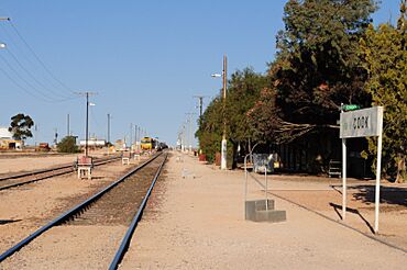
Cook railway station is now unattended but remains a principal stopping place for trains to take on diesel fuel and water, about half-way along their 1687 kilometres (1048 miles) journey on the Trans-Australian Railway
|
|
| Population | Not available. Population data are only available for Nullarbor, an area of about 50,000 square kilometres (19,000 square miles) within which Cook lies, which in the 2021 census had a population of 71. |
| Established | 1917 |
| Elevation | 120 m (394 ft) |
| Time zone | ACST (UTC+9:30) |
| • Summer (DST) | ACDT (UTC+10:30) |
| LGA(s) | Pastoral Unincorporated Area |
Cook is a special railway stop in South Australia. It's located on the Trans-Australian Railway, a very long train line that crosses Australia. Cook is about 824 kilometers (512 miles) from Port Augusta and 863 kilometers (536 miles) from Kalgoorlie.
This unique spot is found on the huge, flat Nullarbor Plain. It's also on the longest straight railway track in the world, which stretches for an amazing 478 kilometers (297 miles)! Cook is the only planned stop on the Nullarbor Plain for the famous Indian Pacific passenger train. Passengers often get off to stretch their legs while the train refuels.
History of Cook
Cook was created in 1917 when the Trans-Australian Railway was being built. It was named after Joseph Cook, who was Australia's sixth Prime Minister.
A Busy Railway Town
In its early days, Cook was a very important center for the Commonwealth Railways. Many people lived there, working on track maintenance and repairing trains. The town even had its own school and a hospital!
Life in Cook was different because it was so isolated. Railway families depended on special "provisions trains" that came twice a week to deliver all their supplies. At first, water for the town was pumped from an underground water source called an artesian aquifer. Later, all the water had to be brought in by train.
A short film from 1955 called Nullarbor Hideout was filmed in and around Cook. It shows what the railway line and the town looked like back then. It also gives a good idea of how isolated the people were and how much they relied on the railway.
Cook Today
After 1997, the railway system changed hands. This meant that many of the jobs in Cook were no longer needed.
Changes to the Railway
Modern diesel trains are much more reliable, and new railway tracks are built with strong concrete sleepers and continuously welded rail. This means less need for people to live in remote towns like Cook to maintain the tracks.
Today, the railway tracks and facilities are looked after by the Australian Rail Track Corporation (ARTC). Cook still has places for trains to refuel with diesel. It also provides overnight accommodation for train crews from Pacific National to rest.
The railway at Cook has a special section called a crossing loop. This allows trains up to 1.8 kilometers (1.1 miles) long to pass each other. The old airstrip near Cook is a good place for birdwatchers to spot a rare bird called the inland dotterel.
As of 2016, Cook is officially known as an "unbounded locality." This means it's a recognized place, but it's not used as a mailing address. Since 2013, it has been part of the larger area known as Nullarbor.
Climate
| Climate data for Cook, South Australia | |||||||||||||
|---|---|---|---|---|---|---|---|---|---|---|---|---|---|
| Month | Jan | Feb | Mar | Apr | May | Jun | Jul | Aug | Sep | Oct | Nov | Dec | Year |
| Record high °C (°F) | 48.7 (119.7) |
46.7 (116.1) |
46.5 (115.7) |
41.1 (106.0) |
36.0 (96.8) |
30.0 (86.0) |
34.2 (93.6) |
33.6 (92.5) |
39.0 (102.2) |
43.5 (110.3) |
46.5 (115.7) |
46.3 (115.3) |
48.7 (119.7) |
| Mean daily maximum °C (°F) | 33.0 (91.4) |
32.2 (90.0) |
30.0 (86.0) |
25.9 (78.6) |
21.8 (71.2) |
18.8 (65.8) |
18.2 (64.8) |
20.1 (68.2) |
23.5 (74.3) |
26.6 (79.9) |
29.7 (85.5) |
31.5 (88.7) |
25.9 (78.7) |
| Mean daily minimum °C (°F) | 15.0 (59.0) |
15.3 (59.5) |
13.7 (56.7) |
10.9 (51.6) |
7.8 (46.0) |
5.4 (41.7) |
4.3 (39.7) |
5.1 (41.2) |
7.2 (45.0) |
9.5 (49.1) |
11.9 (53.4) |
13.9 (57.0) |
10.0 (50.0) |
| Record low °C (°F) | 4.5 (40.1) |
4.4 (39.9) |
4.5 (40.1) |
2.0 (35.6) |
−1.8 (28.8) |
−3.8 (25.2) |
−4.5 (23.9) |
−3.3 (26.1) |
−0.7 (30.7) |
0.0 (32.0) |
3.7 (38.7) |
5.6 (42.1) |
−4.5 (23.9) |
| Average rainfall mm (inches) | 12.1 (0.48) |
14.6 (0.57) |
16.9 (0.67) |
16.2 (0.64) |
15.1 (0.59) |
16.8 (0.66) |
13.2 (0.52) |
15.1 (0.59) |
13.2 (0.52) |
17.3 (0.68) |
14.9 (0.59) |
18.2 (0.72) |
183.6 (7.23) |
| Source: Australian Government, Bureau of Meteorology | |||||||||||||
 | Janet Taylor Pickett |
 | Synthia Saint James |
 | Howardena Pindell |
 | Faith Ringgold |


