
Copperopolis, California facts for kids
Quick facts for kids
Copperopolis
|
|
|---|---|

Location in Calaveras County and the state of California
|
|

Copperopolis, California
Location in the United States
|
|
| Country | |
| State | |
| County | Calaveras |
| Area | |
| • Total | 15.61 sq mi (40.44 km2) |
| • Land | 15.59 sq mi (40.38 km2) |
| • Water | 0.02 sq mi (0.06 km2) 3.09% |
| Elevation | 997 ft (304 m) |
| Population
(2020)
|
|
| • Total | 3,400 |
| • Density | 218.09/sq mi (84.21/km2) |
| Time zone | UTC-8 (Pacific (PST)) |
| • Summer (DST) | UTC-7 (PDT) |
| ZIP code |
95228
|
| Area code(s) | 209 |
| FIPS code | 06-16210 |
| GNIS feature IDs | 1655921, 2407658 |
| Reference #: | 296 |
Copperopolis is a small town in Calaveras County, California. It's known as a census-designated place (CDP), which means it's a community that isn't officially a city but is recognized for census purposes. In 2010, about 3,671 people lived here. The town is located along State Route 4 and is a registered California Historical Landmark.
Contents
Exploring Copperopolis's Past
Unlike many towns in Calaveras County that became famous for gold, Copperopolis was all about copper. It was founded in 1860 by William K. Reed, Dr. Allen Blatchly, and Thomas McCarty. They discovered a large amount of copper ore here, which was the second major find in the area.
How Copperopolis Grew
William K. Reed and Thomas McCarty started the Union Copper Mine. Later, they also opened the Keystone and Empire mines. In 1862, Reed sold his share in the mines. He then built a special road, called "Reeds Turnpike," from Copperopolis to Stockton. This road was a toll road until 1865, meaning people had to pay to use it. Copperopolis was also an important stop on the main stagecoach route between Sonora and Sacramento.
Copper's Role in History
The town grew very quickly because copper was in high demand during the Civil War. Copper was needed to make military supplies. The mined copper was sent to Stockton, then to San Francisco. From there, it traveled by ship all the way around Cape Horn to smelters on the East Coast. Smelters are places where metal is melted to remove impurities.
After the war, mining and shipping copper became too expensive. The mines closed, and many people moved away. However, a company from Boston bought the mines in the 1880s, and mining started again. The town experienced new booms during World War I and World War II when the need for copper increased once more.
By the time the mines closed for good in 1946, they had produced over 72 million pounds of copper. This copper was worth more than $12 million at the time, which would be about $160 million today! No copper mining has happened in Copperopolis since then. The first post office in the town opened in 1861.
Historic Buildings to See
Copperopolis has four buildings that are listed on the National Register of Historic Places. These buildings are important parts of the town's history:
-
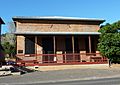
Copperopolis Armory
-
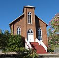
Copperopolis Congregational Church
-
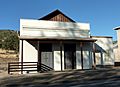
Honigsberger Store
-
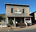
Reed's Store


Where is Copperopolis?
Copperopolis is located in Calaveras County. The town covers an area of about 22.1 square miles (57.2 square kilometers). Most of this area is land, with a small part being water.
What is the Weather Like?
Copperopolis has a Mediterranean climate. This means it has cool winters with a lot of rain, but also sunny days. The summers are hot and dry, with almost no rain in July and August. Snow is very rare in Copperopolis, usually only a tiny bit in winter.
Who Lives in Copperopolis?
According to the 2020 census, the population of Copperopolis was 3,400 people. In 2010, the population was 3,671. Most people in Copperopolis live in family homes.
Copperopolis in Books
Copperopolis is mentioned in connection with the famous American writer Mark Twain. It is believed that he wrote one of his most well-known stories, "The Celebrated Jumping Frog of Calaveras County," in a shack on Jack Ass Hill, which is near Copperopolis. The novel Copperopolis by K. Martin Gardner also talks about this literary history and Twain's friendship with scientist Nikola Tesla.
See also
 In Spanish: Copperopolis para niños
