
Corrigasleggaun facts for kids
Quick facts for kids Corrigasleggaun |
|
|---|---|
| Carraig na Sliogán | |

Looking at summit from the glen of the Carrawaystick River
|
|
| Highest point | |
| Elevation | 794 m (2,605 ft) |
| Prominence | 49 m (161 ft) |
| Listing | Hewitt, Arderin, Simm, Vandeleur-Lynam |
| Naming | |
| English translation | rock of the shells or flat stones |
| Language of name | Irish |
| Geography | |

Corrigasleggaun
Location in island of Ireland
|
|
| Location | Wicklow, Ireland |
| Parent range | Wicklow Mountains |
| OSI/OSNI grid | T047910 |
| Topo map | OSi Discovery 56 |
| Geology | |
| Mountain type | Aphyric granodiorite Bedrock |
Corrigasleggaun (which means "Rock of the shells" in Irish) is a mountain in Ireland. It stands tall at 794 metres (about 2,605 feet). This makes it one of the highest peaks in the country.
Corrigasleggaun is located in the southwestern part of the Wicklow Mountains. This mountain range is famous for its beautiful scenery. Corrigasleggaun is also part of a larger group of mountains around Lugnaquilla. Lugnaquilla is the highest mountain in Wicklow, reaching 925 metres (about 3,035 feet).
Contents
Exploring Corrigasleggaun's Surroundings
Corrigasleggaun is surrounded by interesting natural features. It sits at the top of a valley called the glen of the Carrawaystick River. This river flows towards the east.
Kelly's Lough: A Scenic Lake
Near the summit of Corrigasleggaun, you'll find a beautiful lake called Kelly's Lough. This lake is in a bowl-shaped valley known as a corrie. It's a very scenic spot.
Carrawaystick Mountain and River Ow
At the base of the glen is Carrawaystick Mountain. Corrigasleggaun also lies next to an area called Lugnaquilla's South Prison. From here, the River Ow flows south. It eventually reaches the Aghavannagh Bridge.
Gallery
-
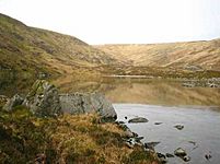
Kelly's Lough
-
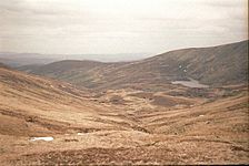
View from summit to Carraystick River
-
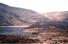
Kelly's Lough, summit behind
-
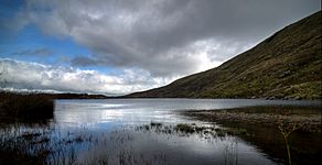
Kelly's Lough, looking east


