
Cosdon Hill facts for kids
Quick facts for kids Cosdon Hill |
|
|---|---|
| Cosdon Beacon, Cawsand Beacon | |
Looking south-south-west from Sampford Courtenay towards Dartmoor with Cosdon Hill prominent on the left
|
|
| Highest point | |
| Elevation | 550 m (1,800 ft) |
| Parent peak | High Willhays |
| Geography | |

Cosdon Hill
Location in Dartmoor
|
|
| Location | Dartmoor, England |
| Parent range | Dartmoor |
Cosdon Hill, also known as Cosdon Beacon or Cawsand Beacon, is one of the tallest hills in Dartmoor, England. This ancient hill holds many secrets from long, long ago, with signs of people living there even before recorded history.
Contents
About Cosdon Hill
Cosdon is a big, rounded hill that stands about 550 meters (1,804 feet) high. The first time this hill was written about was in 1240. Back then, it was called Hoga de Cossdonne. This name likely means "Cost(a)'s hill," named after a person.
For a long time, people thought Cosdon was the highest hill on Dartmoor. Its large shape made it seem taller than it was. In 1809, mapmakers from the Ordnance Survey used special tools to measure the land. Their first map of Dartmoor showed that another hill, Yes Tor, was actually higher.
Even after this, some people still believed Cosdon was the tallest. In 1830, a writer named Samuel Rowe said it was the highest. An 1894 guide for cyclists mentioned how huge Cosdon looked. It said that if it weren't for the clouds often covering its top, you wouldn't believe it was 1,799 feet high.
Today, we know that the nearby High Willhays is the true highest point on Dartmoor. It stands at 621 meters (2,039 feet).
From the top of Cosdon Hill, you can often see the English Channel. On a clear day, you might even spot the Bristol Channel. The hill offers amazing views across all of Dartmoor. As one writer, Thomas Clifton Paris, said in 1865, it's a "solitary wondrous region" with "fantastic rocks."
Ancient History

People have lived around Cosdon Hill for thousands of years. A very old flint axe from the Neolithic period (New Stone Age) was found here. This shows that people were using tools and living in the area a long, long time ago.
Around the western side of the hill, there are signs of nine Bronze Age settlements. These were places where people lived during the Bronze Age. There are also old stone walls, called reaves, that might have marked the edges of different family lands.
You can also find many stone cairns on the hill. These are piles of stones, often used as burial mounds. There are also kistvaens, which are stone-lined graves, and long lines of stones called stone rows. Some people think there might even be a stone circle here. Sadly, some of these ancient structures have been damaged over time. People took stones from them to build other things.
On the very top of Cosdon Hill, there's a very large cairn. This big pile of stones might have been a place where people lit beacons. Beacons were fires used to send signals or warnings across the land.
In 1896, a report described three parallel lines of stones on the east side of Cosdon. These lines started from a cairn that had a stone circle around it. The report noted that people were building a wall nearby and had been breaking up stones from the ancient sites for years. Inside the large cairn, two kistvaens were found. One was still complete, but parts of the other were missing.
Dartmoor's Boundaries
In 1238, Dartmoor was called a "forest." This didn't mean it was full of trees, but that it was a special hunting ground owned by the king. In 1248, King Henry III of England gave Dartmoor to his brother, Richard.
To figure out exactly where the "Forest of Dartmoor" ended, twelve people called "Perambulators" walked around its edges. They started their journey at Cosdon Hill in the north part of Dartmoor. They walked all the way around the moor and then returned to Cosdon, marking the official boundary.
In 1848, Samuel Rowe wrote that they started near the bottom of the hill, close to the Taw river. However, another writer, Arthur B. Prowse, thought in 1892 that the starting point was simply the very top of Cosdon Hill.
Later Uses
In the 1840s, people started mining on Cosdon Hill. They dug a tunnel, called an adit, into the hill and found valuable minerals like mispickel and copper ore. In 1851, a mine shaft was dug for the Ivy Tor Copper mine. This mine operated for several years. Later, Ivy Tor mine joined with another mine to form Belstone Consoles. The mispickel found here also contained bismuth.
For some time, Cosdon Hill was used for hunting birds like grouse and even deer. You can still see some old stone shelters, called shooting butts, on the north and east sides of the hill. These were used by hunters.
At the very top of Cosdon Hill, there is a "trig point." This is a special marker used by surveyors to measure the land. From this trig point, you can see a very wide area of the country.
On Cawsand Beacon
The writer Elias Tozer (1825–73) wrote a poem about Cosdon Hill, which he called Cawsand Beacon:
Rolling o’er the purple heather,
In the glorious Summer weather,
Staining lips with whortleberries,
Sweet as any figs or cherries.
Sipping from the crystal stream,
Lying on the banks to dream,
Watching skylarks soar above
Singing, with them, strains of love.
Gazing over boundless plain,
List’ning to the sweet refrain
Of the rivulets and rills
As they flow by distant hills;
Hearing voices, strange and low,
Mystic tones that come and go,
Seeing tors salute each other,
Every one a friend and brother.
Images for kids
-
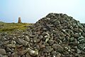
Cairn and triangulation point on the summit
