High Willhays facts for kids
Quick facts for kids High Willhays |
|
|---|---|

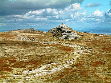
High Willhays with Yes Tor beyond
|
|
| Highest point | |
| Elevation | 621 m (2,039 ft) |
| Prominence | c. 537 m (1,762 ft) |
| Parent peak | Cross Fell |
| Listing | Marilyn, Hewitt, County Top, Nuttall |
| Geography | |
| Location | Dartmoor, England |
| OS grid | SX580892 |
| Topo map | OS Landranger 191 |
| Climbing | |
| Easiest route | From Meldon Reservoir, SX 562918 |
High Willhays (pronounced WIL-eez or WIL-hayz) is the highest point on Dartmoor in Devon, England. It stands at about 622 meters (2,039 feet) above sea level. This makes it the highest point in the United Kingdom south of the Brecon Beacons in Wales. Some people also call it High Willes.
Contents
What's in a Name?
Have you ever wondered how places get their names? The name High Willhays has a few interesting ideas behind it.
Old Ideas for the Name
In 1912, a writer named William Crossing studied the names of places. He thought the name High Willes might come from an old word for "mine" (like huel or wheal). But he didn't think this was very likely. Mines were usually found near streams, and High Willhays isn't.
Instead, William Crossing suggested the name might come from gwylfa. This old word means "a watching place." He noticed that High Willhays is similar to Brown Willy, the highest hill on nearby Bodmin Moor. People might have used High Willhays to watch for beacon fires. These fires were used to send signals or warnings long ago.
Later Thoughts on the Name
A book called The Place-Names of Devon (published in 1931) also looked into the name. It showed that the peak was called Hight Wyll in a document from 1532. Later, in 1827, it was known as High Willows. The authors of the book thought the name could simply mean "high" and "well" (meaning a spring of water). However, they found it hard to explain the extra sound at the end of the name.
Dartmoor's Highest Point
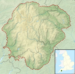
High Willhays is located near the northwest edge of Dartmoor. It's about 2.5 kilometers (1.5 miles) southeast of Meldon Reservoir. It's also about 5 kilometers (3 miles) south of the town of Okehampton.
The "Roof of Devon"
Even though High Willhays is the highest point on Dartmoor, it doesn't look like a huge, pointy mountain. It's more like a few low rock piles along a ridge that runs north to south. The biggest rock pile has a stone cairn (a pile of stones) on top.
Just about 1 kilometer (0.6 miles) north of High Willhays is Yes Tor. Yes Tor looks more impressive, but it's actually a little bit lower. This ridge, which includes both High Willhays and Yes Tor, is sometimes called "the roof of Devon."
Measuring the Heights
High Willhays and Yes Tor are special. They are the only two peaks in England south of Kinder Scout in the Peak District that rise above 610 meters (2,000 feet). The only other one is Black Mountain on the border with Wales.
For a long time, many people thought Yes Tor was taller than High Willhays. Only local farmers and people who knew the moor well believed High Willhays was higher. When the Ordnance Survey (the official mapmakers) first measured the area, they found High Willhays was about 3.6 meters (12 feet) taller. Today, the difference is measured at just 2.4 meters (8 feet).
What High Willhays is Made Of
Like most of Dartmoor, High Willhays is made of granite. This rock formed about 280 million years ago. The rocks here have fewer of the large, visible crystals that you might see in other rock formations on Dartmoor.
Safety on the Moor
High Willhays is located inside one of Dartmoor's "Danger Zones." These are areas that the British Army sometimes uses for training exercises. When live-firing is happening, you will see red flags raised around the edges of these areas. This is a warning to stay away for your safety.
 | James Van Der Zee |
 | Alma Thomas |
 | Ellis Wilson |
 | Margaret Taylor-Burroughs |


