
Council Grove Lake facts for kids
Quick facts for kids Council Grove Lake |
|
|---|---|
 |
|

Council Grove Lake
Location in Kansas

Council Grove Lake
Location in the United States
|
|

|
|
| Location | Morris County, Kansas |
| Coordinates | 38°41′59″N 96°31′10″W / 38.69972°N 96.51944°W |
| Type | Reservoir |
| Primary inflows | Munkers Creek, Neosho River |
| Primary outflows | Neosho River |
| Catchment area | 245 sq mi (630 km2) |
| Basin countries | United States |
| Managing agency | U.S. Army Corps of Engineers |
| Built | June 1960 |
| First flooded | October 9, 1964 |
| Surface area | 3,235 acres (13.09 km2) |
| Max. depth | 56 ft (17 m) |
| Water volume | Full: 43,984 acre⋅ft (54,253,000 m3) Current (Jan. 2016): 44,443 acre⋅ft (54,820,000 m3) |
| Shore length1 | 40 mi (64 km) |
| Surface elevation | Full: 1,274 ft (388 m) Current (Jan. 2016): 1,274 ft (388 m) |
| Settlements | Council Grove |
| 1 Shore length is not a well-defined measure. | |
Council Grove Lake is a large, man-made lake in east-central Kansas. It was built on the Neosho River. The U.S. Army Corps of Engineers built and now manages the lake. It helps control floods, provides water, and is a popular spot for fun activities.
Contents
Building Council Grove Lake
Why the Lake Was Built
The idea for Council Grove Lake came from a law passed in 1950. This law allowed for the building of Council Grove Dam and Lake. The lake is named after the nearby town of Council Grove, Kansas.
A very big flood in 1951 showed how much a lake like this was needed. So, in June 1960, construction began. The lake was finished for about $11.5 million. It started helping with flood control on October 9, 1964.
Where is Council Grove Lake?
Location and Surroundings
Council Grove Lake is located in the Flint Hills area of east-central Kansas. It sits entirely within Morris County. The lake is about 1,274 feet (388 m) above sea level.
The Dam and Water Flow
The lake is held back by the Council Grove Dam at its southeast end. The dam is about 1,276 feet (389 m) above sea level.
The lake has two main parts, like arms. One arm gets most of its water from the Neosho River in the northwest. The other arm gets water from Munkers Creek in the northeast. The Neosho River also flows out of the lake to the southeast. Smaller streams like Slough Creek, Canning Creek, Short Creek, and Richey Creek also feed into the lake.
Nearby Roads and Towns
You can find U.S. Route 56 about 1.5 miles (2.4 km) south of the lake. Kansas Highway 177 runs along the lake's eastern side. Lake Road is a paved county road along the southwest shore.
The town of Council Grove is about 1 mile (1.6 km) southeast of the dam.
How the Lake Works
Water Levels and Size
The amount of water in Council Grove Lake changes. This depends on how much rain falls and how much water flows in. When the lake is full, it covers about 3,235 acres (13.09 km2). Its surface is about 1,274 feet (388 m) above sea level. At this level, it holds about 43,984 acre-feet (54,253,000 m3) of water.
If the lake fills up to its highest possible level, it can reach 1,294 feet (394 m) high. At this point, it holds about 131,078 acre-feet (161,682,000 m3) of water.
The Dam's Structure
Council Grove Dam is an earth-fill dam. This means it's made of packed earth. It stands 96 feet (29 m) tall above the riverbed and is 6,500 feet (2,000 m) long. The very top of the dam is 1,321 feet (403 m) high.
The dam has a special overflow area called a spillway. It's 500-foot (150 m) wide and helps release extra water safely. There are also other ways for water to flow out, like a large pipe and a smaller low-flow pipe.
Managing the Lake
Who Manages It?
The U.S. Army Corps of Engineers manages Council Grove Dam and Lake. They make sure it helps with flood control, provides water, and is a good place for fun. They also work to keep the water clean.
Wildlife Area
The Kansas Department of Wildlife, Parks and Tourism (KDWP) manages about 2,000 acres (8.1 km2) of land around the northern parts of the lake. This area is called the Council Grove Wildlife Area. It's a protected home for many animals.
Fun Things to Do at the Lake
Parks and Camping
The Corps of Engineers manages eight parks around the lake. These include Canning Creek Cove, Santa Fe Trail, Marina Cove, Neosho Park, Custer Park, Kit Carson Cove, Richey Cove, and Kansa View.
- All eight parks have places where you can camp.
- Most parks have boat ramps for launching boats.
- Canning Creek Cove, Neosho Park, and Richey Cove have hiking trails.
- Richey Cove is where you'll find the lake's only swimming beach.
Fishing and Hunting
Council Grove Lake is a great place for sport-fishing. You can also hunt on the public land around the lake, but there are some rules to follow.
Animals and Fish
Fish in the Lake
Many kinds of fish live in Council Grove Lake. These include:
- black bass
- channel and flathead catfish
- crappie
- saugeye
- white bass
- wiper
There is also an invasive species called the zebra mussel in the lake.
Wildlife Around the Lake
On the land around the lake, you might see various game animals like:
Images for kids
-
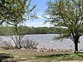
View of the lake from a Richey Cove campsite

