
Council Grove, Kansas facts for kids
Quick facts for kids
Council Grove, Kansas
|
|
|---|---|
|
City and County seat
|
|
.jpg)
Downtown Council Grove (2012)
|
|

Location within Morris County and Kansas
|
|

|
|
| Country | United States |
| State | Kansas |
| County | Morris |
| Incorporated | 1887 |
| Government | |
| • Type | Mayor–Council |
| Area | |
| • Total | 2.06 sq mi (5.32 km2) |
| • Land | 2.04 sq mi (5.29 km2) |
| • Water | 0.01 sq mi (0.03 km2) |
| Elevation | 1,234 ft (376 m) |
| Population
(2020)
|
|
| • Total | 2,140 |
| • Density | 1,039/sq mi (402.3/km2) |
| Time zone | UTC-6 (CST) |
| • Summer (DST) | UTC-5 (CDT) |
| ZIP codes |
66846, 66873
|
| Area code | 620 |
| FIPS code | 20-15925 |
| GNIS ID | 477021 |
Council Grove is a city in Morris County, Kansas, United States. It is also the county seat, which means it's where the main government offices for the county are located. In 2020, about 2,140 people lived there.
The city got its name from an important meeting. American settlers and the Osage Nation agreed here that wagon trains could travel through the area. This was part of the famous Santa Fe Trail. Pioneers often gathered at a special grove of trees before continuing their journey west.
Contents
History of Council Grove


Council Grove was a key stop on the Santa Fe Trail, a historic route for trade and travel. The first European-American settler was Seth M. Hays. He arrived in 1847 to trade with the Kaw tribe, who had a reservation nearby. Seth Hays was a great-grandson of the famous explorer Daniel Boone.
The main street in Council Grove is actually the old Santa Fe Trail itself! The Rawlinson-Terwilliger Home, located at 803 West Main Street, is the oldest stone house on the trail. Today, it is home to the Trail Days Cafe & Museum.
A post office was set up in Council Grove on February 26, 1855. The town was officially made a city by the government in 1858. Seth Hays also opened a restaurant in 1857 called the Hays House. People say it's the oldest restaurant that has been open continuously west of the Mississippi River.
Council Grove has 15 places listed on the National Register of Historic Places. One of these is the Post Office Oak. Travelers used to leave their mail in this special tree for others to pick up and deliver if they were going in the right direction. Even General Custer and his soldiers stayed here during the American Civil War. They camped under a large tree now known as the Custer Elm.
The National Old Trails Road, also called the Ocean-to-Ocean Highway, was created in 1912. This important road passed through Council Grove.
During World War II in 1943, some German and Italian prisoners of war came to Kansas. They helped with labor shortages because many American men were away fighting in the war. Large camps were set up in Kansas, and Fort Riley had smaller branch camps, including one in Council Grove.
Geography and Climate
Council Grove covers about 2 square miles (5.2 square kilometers). Most of this area is land, with a small amount of water. The city is located about 55 miles (88 kilometers) southwest of Topeka, the capital of Kansas.
Local Climate
The weather in Council Grove usually has hot, humid summers. Winters are generally mild to cool. This type of climate is called a humid subtropical climate.
| Climate data for Council Grove, Kansas (1991–2020 normals, extremes 1908–present) | |||||||||||||
|---|---|---|---|---|---|---|---|---|---|---|---|---|---|
| Month | Jan | Feb | Mar | Apr | May | Jun | Jul | Aug | Sep | Oct | Nov | Dec | Year |
| Record high °F (°C) | 76 (24) |
82 (28) |
95 (35) |
95 (35) |
101 (38) |
112 (44) |
115 (46) |
115 (46) |
111 (44) |
99 (37) |
88 (31) |
76 (24) |
115 (46) |
| Mean maximum °F (°C) | 63.6 (17.6) |
69.7 (20.9) |
79.4 (26.3) |
86.4 (30.2) |
90.3 (32.4) |
95.0 (35.0) |
101.2 (38.4) |
100.1 (37.8) |
94.7 (34.8) |
87.7 (30.9) |
75.5 (24.2) |
65.4 (18.6) |
102.8 (39.3) |
| Mean daily maximum °F (°C) | 40.2 (4.6) |
45.3 (7.4) |
56.3 (13.5) |
66.5 (19.2) |
75.4 (24.1) |
85.1 (29.5) |
90.2 (32.3) |
89.1 (31.7) |
81.3 (27.4) |
69.3 (20.7) |
55.4 (13.0) |
43.5 (6.4) |
66.5 (19.2) |
| Daily mean °F (°C) | 29.9 (−1.2) |
34.2 (1.2) |
44.7 (7.1) |
55.0 (12.8) |
65.2 (18.4) |
74.8 (23.8) |
79.8 (26.6) |
78.0 (25.6) |
69.5 (20.8) |
57.1 (13.9) |
44.2 (6.8) |
33.6 (0.9) |
55.5 (13.1) |
| Mean daily minimum °F (°C) | 19.7 (−6.8) |
23.2 (−4.9) |
33.1 (0.6) |
43.5 (6.4) |
54.9 (12.7) |
64.5 (18.1) |
69.3 (20.7) |
66.9 (19.4) |
57.8 (14.3) |
44.8 (7.1) |
33.0 (0.6) |
23.7 (−4.6) |
44.5 (6.9) |
| Mean minimum °F (°C) | 0.1 (−17.7) |
5.3 (−14.8) |
14.3 (−9.8) |
27.3 (−2.6) |
38.9 (3.8) |
51.3 (10.7) |
58.2 (14.6) |
55.4 (13.0) |
41.8 (5.4) |
27.4 (−2.6) |
16.1 (−8.8) |
6.4 (−14.2) |
−3.6 (−19.8) |
| Record low °F (°C) | −21 (−29) |
−23 (−31) |
−9 (−23) |
2 (−17) |
25 (−4) |
39 (4) |
44 (7) |
40 (4) |
28 (−2) |
14 (−10) |
−6 (−21) |
−24 (−31) |
−24 (−31) |
| Average precipitation inches (mm) | 0.76 (19) |
1.26 (32) |
2.24 (57) |
3.42 (87) |
5.15 (131) |
4.87 (124) |
4.41 (112) |
4.42 (112) |
3.19 (81) |
2.42 (61) |
1.73 (44) |
1.12 (28) |
34.99 (889) |
| Average snowfall inches (cm) | 4.0 (10) |
2.9 (7.4) |
1.2 (3.0) |
0.2 (0.51) |
0.0 (0.0) |
0.0 (0.0) |
0.0 (0.0) |
0.0 (0.0) |
0.0 (0.0) |
0.4 (1.0) |
0.5 (1.3) |
2.8 (7.1) |
12.0 (30) |
| Average precipitation days (≥ 0.01 in) | 5.0 | 5.1 | 7.2 | 9.4 | 11.2 | 9.2 | 9.2 | 8.9 | 7.3 | 7.0 | 5.4 | 4.8 | 89.7 |
| Average snowy days (≥ 0.1 in) | 2.6 | 1.6 | 0.6 | 0.1 | 0.0 | 0.0 | 0.0 | 0.0 | 0.0 | 0.0 | 0.5 | 1.8 | 7.2 |
| Source: NOAA | |||||||||||||
Population of Council Grove
| Historical population | |||
|---|---|---|---|
| Census | Pop. | %± | |
| 1870 | 712 | — | |
| 1880 | 1,042 | 46.3% | |
| 1890 | 2,211 | 112.2% | |
| 1900 | 2,265 | 2.4% | |
| 1910 | 2,545 | 12.4% | |
| 1920 | 2,857 | 12.3% | |
| 1930 | 2,898 | 1.4% | |
| 1940 | 2,875 | −0.8% | |
| 1950 | 2,722 | −5.3% | |
| 1960 | 2,664 | −2.1% | |
| 1970 | 2,403 | −9.8% | |
| 1980 | 2,381 | −0.9% | |
| 1990 | 2,228 | −6.4% | |
| 2000 | 2,321 | 4.2% | |
| 2010 | 2,182 | −6.0% | |
| 2020 | 2,140 | −1.9% | |
| U.S. Decennial Census | |||
2020 Census Details
The 2020 United States census showed that 2,140 people lived in Council Grove. There were 912 households, which are groups of people living together. About 29.6% of these households had children under 18. Most people (about 90.89%) were white. About 7.1% of the population was Hispanic or Latino.
The average age in the city was 41.3 years old. About 23.8% of the people were under 18 years old.
2010 Census Details
In the census of 2010, there were 2,182 people living in Council Grove. The city had 991 households. Most people (95.8%) were white. About 6.0% of the population was Hispanic or Latino.
The average age in the city was 45.9 years. About 21.7% of the people were under 18 years old.
Fun Things to Do
Council Grove has several events and attractions for visitors and locals.
Area Events
- Heritage Rendezvous
- Washunga Days
Area Attractions
- Allegawaho Heritage Memorial Park
- Kaw Mission State Historic Site
- 1857 Hays House
- Madonna of the Trail monument
- Trail Days Historic Site
The Council Grove Reservoir and the City Lake are popular spots for outdoor activities. You can enjoy fishing for walleye, crappie, and white bass in both lakes. While the City Lake has many lake houses around it, the larger Council Grove Reservoir offers many great campsites.
Education in Council Grove

The public schools in Council Grove are part of the Morris County USD 417 school district.
- Council Grove High School is for older students and is located at 129 Hockaday St. Students from nearby areas also come here for high school.
- Council Grove Middle School serves grades 6 through 8 and is at 706 E Main St.
- Council Grove Elementary School is for kindergarten through 5th grade and is connected to the middle school.
The school sports teams are known as the Braves.
Transportation
Council Grove was an important stop on the National Old Trails Road. This road, also known as the Ocean-to-Ocean Highway, was created in 1912.
Famous People from Council Grove
- Charles Curtis: He was the Vice President of the United States from 1929 to 1933. He was also a member of the Kaw Indian tribe.
- Don Harvey: An actor.
- Clara Hazelrigg: An author, educator, and social reformer.
- James Miller: A U.S. Representative from Kansas.
- John Rhodes: A U.S. Representative from Arizona from 1952 to 1983. He was also the House Republican Leader.
Images for kids
-
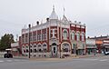
Historic Farmers and Drovers Bank building (2012)
-
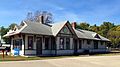
1894 Missouri, Kansas & Texas Railway Depot (2015)
-
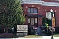
Morris County Historical Society, previously was a Carnegie Library (2015)
-
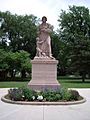
Madonna of the Trail monument in Council Grove (2005)
-
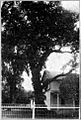
Council Oak at Council Grove (1912)
-
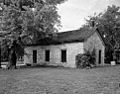
1857 Historic Last Chance Store (1958)
.jpg)


See also
 In Spanish: Council Grove (Kansas) para niños
