Cove Brook facts for kids
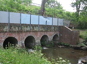
Cove Brook is a small river, about 4 miles (6.4 km) long, located in Hampshire, England. It starts near Farnborough Airport in Farnborough and flows through the old Southwood Golf Course. It then goes north through Cove before joining a bigger river called the Blackwater near the M3 motorway.
Contents
Where Does Cove Brook Flow?
Cove Brook officially begins on the former Southwood Golf Course. Here, four smaller streams meet to form the main brook.
Starting Streams
- Marrow Brook: This stream flows from Farnborough Business Park.
- Hungry Hill Stream: This stream starts near Hungry Hill in Aldershot. It flows under the Basingstoke Canal and the runways of Farnborough Airport.
- Eelmoor Marsh Stream: This stream comes from a network of channels on Eelmoor Marsh. It also passes under the A327 road.
- Pyestock Stream: This stream starts in other channels within Southwood Woodland.
Changes Over Time
In the 1930s, the part of the brook now under the airport was also called Cove Stream. It used to carry water from Cove Reservoir, which even had a boathouse! As the airport grew, the reservoir was removed, and more of the stream was covered up in underground pipes called culverts.
Marrow Brook was also mostly on the surface in 1964. But as more houses were built, the meadows of Southwood Farm became a special area to hold floodwater. A straight, concrete channel was built for the brook, which wasn't very good for nature at the time. North of the railway bridge, the channel was made wider and deeper to help prevent floods. The amount of water in the brook also increased because treated water from Cove sewage works flowed into it.
Hawley Lake Stream
Cove Brook is also joined by Hawley Lake Stream. This stream drains Hawley Lake, a large lake covering about 35 acres (14 hectares). Hawley Lake is home to the Hawley Lake Sail Training Centre, where people can learn to sail. The stream flows under two roads and the M3 motorway before joining Cove Brook.
Making the Brook More Natural
In 1996, a project called the Cove Brook environmental initiative began. The Environment Agency removed some of the concrete sections and made the channel look more natural. They also changed the riverbanks so that the water would clean the riverbed itself, meaning less dredging was needed. They stopped mowing the banks so often, allowing plants to grow and create better homes for wildlife. Volunteers from the Cove Brook Greenway Group also helped create paths along most of the river, making it a nice place to walk.
Cove Brook Greenway
The Cove Brook Greenway is a special pathway and leisure area along the brook. It was created in the 1990s by Rushmoor Borough Council, working with the Environment Agency and Hampshire and Isle of Wight Wildlife Trust.
What Was Done?
Before this project, much of the brook was just a concrete channel. The Environment Agency worked to make it more natural. Even though it runs through a town, it's now a 2-mile (3.2 km) green pathway full of wildlife.
The work included:
- Building new paths.
- Adding a footbridge across the brook.
- Creating safe dipping areas where people can get close to the water.
Volunteer Efforts
In 1996, local people formed the Cove Brook Greenway Group. These volunteers have done even more work, like clearing rubbish, planting hedges, and creating a nature reserve. They've also put up bat boxes and regularly check on the wildlife.
Wildlife You Might See
Many different animals have been spotted along the Greenway, including:
- Herons
- Kingfishers
- Various types of fish
- Egrets (a type of heron)
- Signal crayfish (a type of freshwater crab)
Water Quality of Cove Brook
The Environment Agency checks the water quality of rivers in England. They give each river an overall "ecological status," which can be high, good, moderate, poor, or bad. This status looks at things like the number and types of invertebrates (like insects), plants, and fish. They also check the "chemical status," which compares chemical levels to safe limits. Chemical status is either good or fail.
Cove Brook's Water Quality in 2019
Here's how Cove Brook's water quality was rated in 2019:
| Section | Ecological Status | Chemical Status | Overall Status | Length | Catchment |
|---|---|---|---|---|---|
| Cove Brook | Poor | Fail | Poor | 4.4 miles (7.1 km) | 8.80 square miles (22.8 km2) |
Why the Quality Isn't Better
The water quality of Cove Brook is not rated as good for a few reasons:
- Flood Protection Structures: Things like weirs and barriers built to prevent floods can stop fish and other creatures from moving freely along the brook.
- Runoff: Water flowing off roads and contaminated land can carry pollution into the brook.
 | Aurelia Browder |
 | Nannie Helen Burroughs |
 | Michelle Alexander |


