
Cow Island, Montana facts for kids
Cow Island is a special island in the Missouri River in Montana. It's found in a curvy part of the river called the Missouri River Breaks. The island is about 1.2 miles (1.9 km) long and 150 yards (137 meters) wide. It formed from sand and dirt washed in by two smaller creeks, Cow Creek and Bull Creek.
Cow Island was very important a long time ago. It was a place where people and animals could cross the Missouri River. It also became a busy stop for steamboats carrying goods. During the Nez Perce War in 1877, the Nez Perce tribe crossed the river here. This led to a fight known as the Battle of Cow Island.

Contents
What are the Missouri Breaks?
To understand why Cow Island was so important, you need to know about the Missouri Breaks. The Missouri Breaks are very steep, eroded hills and valleys along the Missouri River. Think of them as a wild, rugged landscape. They stretch for over 200 miles (320 km) and are very hard to travel through. Even today, this area is one of the most remote places in Montana.
These breaks were formed during the last ice age. A huge sheet of ice from Canada blocked the Missouri River. This created a giant lake. When the lake finally broke through the ice dam, the rushing water carved a new path for the river. This new path cut through soft rock, creating the steep hills and valleys we see today.
Crossing the Missouri River at Cow Island
About 10,000 years ago, after the ice age, Cow Island became a popular place to cross the Missouri River. It was used by huge herds of buffalo and by Native American tribes. For more than 100 miles (160 km) in either direction, the Missouri Breaks made it very difficult to reach the river.
But at Cow Island, it was different. People and animals could follow Cow Creek for about 25 miles (40 km) from the northern plains. This path helped them avoid the rough land of the breaks. Once they reached the river, Cow Island split the wide Missouri into two smaller channels. This made it much easier to cross. On the south side of the island, a short, steep trail led through the breaks to the open grasslands.
Cow Island wasn't the only place to cross the river in this area. However, it was the easiest one to get to.
Steamboats and Cow Island Landing

From the early 1860s to the late 1880s, Cow Island was a busy steamboat landing. Steamboats brought goods up the Missouri River to the gold fields of Montana. Their main goal was Fort Benton, which was as far as steamboats could go.
However, in late summer, the river often became too shallow. Large steamboats couldn't get past some rapids above Cow Island. So, they had to unload their goods at a spot further downstream in the Missouri Breaks. Cow Island was a common place for this. From there, the goods were moved overland to Fort Benton.
Cow Creek was one of the few routes that wagons could use to get through the breaks from the river to the plains. Because of this, Cow Island became a very important transfer point. Goods were quickly moved from the steamboats onto wagons. No permanent buildings were built at Cow Island because the goods didn't stay there long. They were simply covered with tarps.
Cow Island stopped being a steamboat landing when railroads reached Fort Benton in the late 1880s. Its time as a busy shipping point was over.
The Cow Island Trail

The wagon road that started at Cow Island Landing and went up Cow Creek was called the Cow Island Trail. After going through the breaks, this road continued onto the Montana prairie and then to Fort Benton. Thousands of pounds of goods from the steamboats were carried up this trail. Large covered wagons, sometimes pulled by 6 to 12 oxen or mules, were used for this.
The trail likely followed Cow Creek for about 15 miles (24 km). Then it went up a ridge called Davidson Coulee and west to the plains, finally reaching Fort Benton. Wagons had to cross Cow Creek many times because the creek wound back and forth.
Freighters often used two wagons pulled by mules, horses, or oxen. Oxen were preferred because Native Americans would steal mules and horses, but not oxen. The climb out of Cow Creek up Davidson Coulee ridge was very steep and narrow. Wagons often had to be pulled up one at a time. Sometimes, wagons would even fall off the road!
The famous artist Charles Russell painted a picture called "The Wagon Boss." It shows wagons being pulled up a steep hill by many oxen. This painting helps us imagine what it was like to move goods on trails like the Cow Island Trail.
When railroads took over from steamboats, the Cow Island Trail was no longer used for freight. Today, a gravel road uses part of the old trail. However, the last 15 miles (24 km) of the original trail down Cow Creek to the Missouri River are not used anymore. It's very hard to travel this part of the old trail by vehicle today.
The Battle of Cow Island
Cow Island was the site of the Battle of Cow Island on September 23, 1877. The Nez Perce people were trying to escape from the U.S. Army and reach Canada. They crossed the Missouri River at the Cow Island ford.
At the Cow Island landing, a small group of soldiers was guarding government supplies. The Nez Perce, numbering about 300, crossed the river in an organized way. The soldiers, only about a dozen men, hid in shallow trenches.
Later that day, some Nez Perce leaders asked the soldiers for food. The sergeant in charge gave them only a tiny amount. The soldiers were in a weak position. They had few men, their camp wasn't well protected, and their supplies were far away. The Nez Perce took advantage of this. As it got dark, Nez Perce warriors fired at the soldiers from the bluffs. While the soldiers were pinned down, the Nez Perce broke into the supply area and took what they needed.
The next day, the Nez Perce moved up Cow Creek. They fought another small battle, sometimes called the Battle of Cow Creek Canyon. They also raided and burned a wagon train. Further up Cow Creek, the Nez Perce decided to stop and rest. This delay allowed General Nelson Miles to catch up with them. This led to the five-day Battle of Bear Paw, where the Nez Perce were surrounded. Their leader, Chief Joseph, gave his famous surrender speech.
Cow Island Today
Today, Cow Island is no longer important for travel or trade. Modern roads and railroads have changed how people get around. U.S. Route 191, the only highway through the breaks, crosses the river about 20 miles (32 km) downstream.
Cow Island is now part of the Upper Missouri River Breaks National Monument. This area is managed by the Bureau of Land Management. The Cow Creek area is even being considered for special "Prairie Wilderness" protection.
Cow Island has gone back to being a quiet, remote spot in Montana. You can still see old, deserted farm buildings in the Cow Creek area. They show how hard it was to live and farm in this distant place.
Getting to Cow Island today is difficult. There's a dirt road, but it's steep and not well kept. It can be impossible to use when it's wet.
Images for kids
-
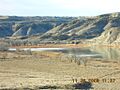
The upstream end of Cow Island in the Missouri River. View from site near mouth of Cow Creek. The Missouri Breaks south of Missouri River in background
-
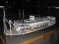
Model of Upper Missouri River stern-wheel steamboat Bertrand, which sank on April 1, 1865, while heading up the Missouri for Fort Benton, Montana Territory
-
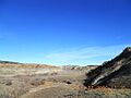
View up Cow Creek, where the Cow Creek Trail ran. Note how the creek bottom provides access through the breaks.
