
Cowles Bog facts for kids
Quick facts for kids Cowles Bog |
|
|---|---|

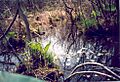
Cowles Bog in the spring with high water.
|
|

Cowles Bog
Location in Indiana
|
|
| Location | Porter County, Indiana, United States |
| Nearest city | Michigan City, Indiana |
| Area | Indiana Dunes National Park |
| Established | 1966 |
| Governing body | National Park Service |
| Designated: | 1965 |
Cowles Bog is a very old wetland area, about 4,000 years old! It's located inside the Indiana Dunes National Park in Indiana. It's near Chesterton, Indiana.
This special place is named after Dr. Henry Chandler Cowles. He was a famous scientist who studied how plants and nature change over time. His work here was very important. Because of his studies, people from all over the world noticed this special place. This helped lead to efforts to protect the Indiana Dunes. In 1965, it was named a National Natural Landmark, which means it's a really important natural site. It has many different types of wet areas, like bogs, marshes, and swamps.
Contents
Why Cowles Bog is Protected
Dr. Cowles wrote many papers about the plants here. In 1913, other scientists from around the world came to see his work. This helped show how important the area was.
Later, a group called the Save the Dunes Council helped buy this wetland. This made sure it would be protected for the future.
Where is Cowles Bog?
This wetland is located west of Mineral Springs Road. You can reach the general area by using the Cowles Bog Trail. This trail is part of the Indiana Dunes National Park.
You can park your car at the trailhead. This is just before the guardhouse to Dune Acres. The trail does not go directly into the bog itself. The plants around the bog make it very hard to get into.
Dr. Cowles studied the bog and the marshlands to the south of the trail. He also studied the sand dunes to the north. Water from Cowles Bog flows into a stream called the West Branch Tributary. This stream then flows into Dunes Creek and eventually into Lake Michigan.
What is Cowles Bog Like?
Cowles Bog is a mix of different wet areas. It's not just one type of bog. The main part of the bog has a lot of muck. This muck is made from old marsh plants and trees.
The ground around the bog has a thin layer of leaves and topsoil. The soil here is a bit acidic. In some wet spots, you can see sandy soil underneath. This sandy soil extends south into the marsh area. To the north, the dunes are made of a different type of sand.
Plants of Cowles Bog
The bog is mostly a wet forest now. In the 1960s, there was more open bog. But now, trees have grown in. The forest is mostly made up of Red maple and Yellow birch trees. You can also find tamarack, Paper birch, and White pine trees. Even the young trees in the forest are mostly Red maple and Yellow birch.
Along the edges of the bog, and in the middle, there are many shrubs. The most common ones are spicebush and poison sumac. The poison sumac makes it very hard to walk through the bog! Other shrubs include witch hazel, red osier, grape vines, and blackberry bushes.
On the ground, you can see many smaller plants. These include columbine, boneset, jewel weed, nettle, twinberry, May apple, hispid greenbrier, meadow rue, and narrow-leaved cattail.
Orchids are becoming more common here. This is because people are working to put them back into their natural homes. A plant called the Purple pitcher plant (Sarracenia purpurea) used to be common. But sadly, it was taken from the area and is not found there anymore.
Animals of Cowles Bog
This wetland area is home to many insects and birds. In 1988, beavers were known to live in the wetlands nearby. You might also see White-tailed Deer in the area.
Restoring Cowles Bog
Since the early 1900s, when Dr. Cowles studied the bog, the land has changed a lot. For example, a diverse meadow of sedges was replaced by mostly one type of plant: cattails.
The National Park Service has found out why these changes happened. Things like changes in water levels, water chemistry, and plant growth have affected the bog. Changes in the soil and the seeds in the ground also played a role. These problems happened because of things built nearby, like roads and drainage ditches.
In 2009, the national lakeshore received money to start fixing the wetlands. This work helps bring the bog back to a healthier state.
Cowles Bog Trail
The Cowles Bog Trail takes you along the northern edge of the bog. The trail has three different loops. They all start at the Cowles Bog Trailhead parking area. You can reach Lake Michigan on this trail. The most direct way is about 1.7 miles (2.7 km).
- The southern loop is 2.0 miles (3.2 km) long around the bog. You can return by walking about 0.8 miles (1.3 km) along Mineral Springs Road.
- The middle loop is 1.7 miles (2.7 km) long. It takes you into the sand dunes and wet areas between them. You need to use 0.8 miles (1.3 km) of the southern loop to get to and from it.
- The northern loop is connected to the middle loop. It is 1.4 miles (2.3 km) long. This loop crosses the dunes closest to the lake and reaches Lake Michigan. This part of the trail is the highest and steepest.
Images for kids
-
Cowles Bog in the spring with high water.
