
Cratfield facts for kids
Quick facts for kids Cratfield |
|
|---|---|
 Church of St Mary, Cratfield |
|

Cratfield
|
|
| Population | 292 (2011) |
| OS grid reference | TM 315 755 |
| District |
|
| Shire county | |
| Region | |
| Country | England |
| Sovereign state | United Kingdom |
| Post town | Halesworth |
| Postcode district | IP19 |
| Dialling code | 01986 |
| EU Parliament | East of England |
| UK Parliament |
|
Cratfield is a small village located in the northern part of Suffolk, England. In 2011, about 292 people lived there.
Nearby villages include Laxfield, Metfield, and Huntingfield. The closest town is Halesworth, which is about 6.7 miles (10.7 km) away. Southwold is a popular seaside town nearby, and the market town of Framlingham is also close.
Cratfield is mainly a farming and residential community. It doesn't have a shop, but there are some places to stay like bed and breakfast hotels. The village's only pub, The Cratfield Poacher, closed in 2017. Cratfield is also home to St Mary's Church, which is a very old building from the 14th, 15th, and 16th centuries. It is made of flint and has a square tower.
The name Cratfield means 'Craeta open land'. This refers to open, treeless, or level ground, and also to land used for growing crops.
Contents
Where is Cratfield?
Cratfield is about 115 miles northeast of London. It is also about 29 miles north of Ipswich and 29 miles south of Norwich. The village is about 7.5 miles from the coast and sits 49 metres (about 160 feet) above sea level.
The ground in the area is made of a mix of London Clay and chalk. These rocks are thought to be between 1.5 and 3.5 million years old. Some volcanic ash is also found here, which shows that there was volcanic activity in the past.
Life in Cratfield Today
Cratfield has 26 buildings that are officially "listed." This means they are important historical buildings. One of them, St Mary's Church, is a Grade I listed building, which is the highest level of protection. The other 25 are Grade II listed.
The village has a community hall on Manse Lane. It can hold up to 100 people. This hall is used for a "Pop-up Pub" on the first Friday of each month. It also hosts regular clubs and groups for villagers.
The nearest primary school is All Saints Church of England Primary School in Laxfield. The closest secondary school is Stradbroke High School. Cratfield does not have regular bus services. However, there are special school buses for students going to Stradbroke High and Thomas Mills in Framlingham.
Cratfield also has two holiday cottages where visitors can stay. Many people in Cratfield own cars or vans. The 2011 census showed that most people in Cratfield are Christian. A smaller number reported having no religion or other faiths like Buddhism or Judaism.
Cratfield used to have two churches and three cemeteries. Today, it has one church, St Mary's, and two cemeteries. The oldest parts of St Mary's Church are from the 14th century, and its tower was built in the 15th century. In 1547, during the time of King Edward VI, the people of Cratfield sold all their church silver. They did this to prevent the government from taking it. They used the money to decorate the church tower instead.
Cratfield's Past
People have written about Cratfield in historical books.
In 1870–72, a writer named John Marius Wilson described Cratfield in his book, the Imperial Gazetteer of England and Wales. He wrote that it was a parish in Suffolk, about 6 miles from Halesworth railway station. He mentioned it had a post office, 2,085 acres of land, and a population of 604 people living in 139 houses. He also noted that the church was "later English" style and had a good square tower. There was also an Independent chapel and a school.
Later, in 1887, John Bartholomew wrote a shorter description of Cratfield in his Gazetteer of the British Isles. He said it was a parish in East Suffolk, 6 miles southwest of Halesworth railway station, with 2,085 acres and a population of 495.
Famous People from Cratfield
- John Laney: He was a politician and lawyer during the time of Queen Elizabeth I. He was a Member of Parliament between 1586 and 1589. The Queen's Privy Council sometimes asked him to help solve problems in Suffolk.
- William Keable: An 18th-century painter. He was known for painting portraits and "conversation pieces." These were paintings of groups of people doing everyday things.
How Cratfield's Population Changed

The biggest drop in Cratfield's population happened between 1891 and 1901. The village lost 75 people during this time. This was likely due to older people dying and health problems from diseases.
On the other hand, the population grew the most between 1801 and 1811. It increased by 100 people. The number of males and females in Cratfield has usually been quite similar over time. However, there were a few times when there was a bigger difference. For example, in 1951, there were 32 more males than females.
The size of Cratfield's area has also grown a little. It expanded from 1,930 acres in 1831 to 2,127 acres. This isn't a huge change, but it shows some expansion.
According to the 2011 census, there isn't a big difference between people working full-time (170 people) and part-time (112 people). Many people who work full-time have to travel between 10 and 20 kilometers (about 6 to 12 miles) to get to their jobs. Some even travel over 60 kilometers (37 miles). This suggests that Cratfield is a bit far from most businesses and industrial areas. These are usually found in bigger towns like Halesworth.

Cratfield's Jobs and Economy

In 1831, a census looked at the jobs people had in Cratfield. There were 22 professionals, 43 "middling sorts," 103 servants, and 6 "others." The "middling sorts" were middle-class people, often craftsmen or farmers. In Cratfield, because of its open land, most of them were likely small-scale farmers. The professionals were the upper class, and they would have hired many of the servants.
The 1881 census showed that many people worked in farming or building carriages. This makes sense because Cratfield's name means "open land," which is good for farming. There were also many domestic servants, meaning some wealthy people lived in the area at that time.
The 2011 census showed that 141 people aged 16 to 74 in Cratfield had jobs. Of these, 18 were managers or senior officials. 20 worked in technical jobs like health or teaching. 13 had administrative jobs, and 34 had skilled trades like plumbing or building. 12 worked in care or leisure, 2 in sales, 7 in machine operations, and 18 in basic jobs.
Images for kids
-
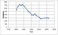
Total population of Cratfield Civil Parish, Suffolk, as reported by the census of population from 1801 to 2011.
-
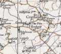
Cratfield 20th century map
-
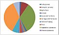
Occupation structure from 1881 census in Cratfield
