Arthur, Wisconsin facts for kids
Quick facts for kids
Arthur, Wisconsin
|
|
|---|---|

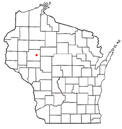
Location of Arthur, Wisconsin
|
|
| Country | |
| State | |
| County | Chippewa |
| Area | |
| • Total | 43.1 sq mi (111.5 km2) |
| • Land | 42.9 sq mi (111.1 km2) |
| • Water | 0.2 sq mi (0.5 km2) |
| Elevation | 1,096 ft (334 m) |
| Population
(2010)
|
|
| • Total | 759 |
| • Density | 18/sq mi (6.8/km2) |
| Time zone | UTC-6 (Central (CST)) |
| • Summer (DST) | UTC-5 (CDT) |
| Area codes | 715 & 534 |
| FIPS code | 55-03075 |
| GNIS feature ID | 1582720 |
| PLSS townships | Most of T30N R6W, part of T30N R7W, and bits of T29N R6W and T29N R7W |
Arthur is a small town located in Chippewa County, Wisconsin, in the United States. In 2010, about 759 people lived there.
The town includes smaller communities. These are Cobban, Crescent, and Drywood.
Contents
Education in Arthur
Students in Arthur attend schools in two different districts. These are the School District of Cadott Community and the Cornell School District.
History of Arthur
Early Land Surveys
The area that would become Arthur was first mapped in 1848. This was done by a team working for the U.S. government. In 1849, another team marked the corners of the land sections. They walked through forests and swamps. They used chains and compasses to measure the land.
After their work, the surveyor described the land. This area was about 6 miles by 6 miles. It became the eastern part of Arthur. He said the land was mostly flat, wet, and cold. There was a lot of good pine wood in the north. The rivers had fast currents and rocky bottoms. They often flooded. He noted that only a small part of the land was good for farming. The area had many trees like birch, maple, pine, ash, and oak. There was also a small lake with low, marshy shores.
Another team surveyed the western part of what is now Arthur. They found some people already living there. They noted six houses in this area.
Founding the Town
The town of Arthur was officially created on January 27, 1885. It was named after Chester A. Arthur. He was the 21st president of the United States. The new town was formed from parts of two other towns. These were Anson and Sigel. H.P. Buchanan was the first town chairman. He held this position until 1890.
Geography of Arthur
Arthur is in the east-central part of Chippewa County. The Chippewa River touches its northwest corner. The town covers a total area of about 111.5 square kilometers (43 square miles). Most of this area, about 111.1 square kilometers (42.9 square miles), is land. The rest, about 0.5 square kilometers (0.2 square miles), is water.
Population of Arthur
| Historical population | |||
|---|---|---|---|
| Census | Pop. | %± | |
| 1990 | 756 | — | |
| 2000 | 710 | −6.1% | |
| 2010 | 759 | 6.9% | |
| 2020 (est.) | 791 | 4.2% | |
In 2000, there were 710 people living in Arthur. There were 258 households. About 16.5 people lived in each square mile. The population changed over the years:
- In 1990, there were 756 people.
- In 2000, there were 710 people.
- In 2010, there were 759 people.
- In 2020, it was estimated that 791 people lived there.
The average age of people in Arthur in 2000 was 37 years old. About 28.6% of the people were under 18 years old.
See also
 In Spanish: Arthur (Wisconsin) para niños
 | Aaron Henry |
 | T. R. M. Howard |
 | Jesse Jackson |

