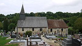
Cresseveuille facts for kids
Quick facts for kids
Cresseveuille
|
|
|---|---|
 |
|
| Country | France |
| Region | Normandy |
| Department | Calvados |
| Arrondissement | Lisieux |
| Canton | Dozulé |
| Intercommunality | Pays d'Auge dozuléen |
| Area
1
|
5.48 km2 (2.12 sq mi) |
| Population
(1999)
|
212 |
| • Density | 38.69/km2 (100.2/sq mi) |
| Time zone | UTC+01:00 (CET) |
| • Summer (DST) | UTC+02:00 (CEST) |
| INSEE/Postal code |
14198 /14430
|
| Elevation | 25–136 m (82–446 ft) (avg. 100 m or 330 ft) |
| 1 French Land Register data, which excludes lakes, ponds, glaciers > 1 km2 (0.386 sq mi or 247 acres) and river estuaries. | |
Cresseveuille is a small and interesting commune. A commune is like a local town or village area in France. It is located in the region called Basse-Normandie. This area is in the Calvados department. Cresseveuille is found in the northwest part of France.
About Cresseveuille
Cresseveuille is a charming place in the French countryside. It is known for its peaceful atmosphere. The commune has a small population. In 1999, about 212 people lived there.
Where is Cresseveuille?
Cresseveuille is part of the Lisieux arrondissement. An arrondissement is a type of administrative district. It is also in the Dozulé canton. A canton is another local division. These divisions help organize the areas of France.
Local Government
The mayor of Cresseveuille is Serge Marie. He served from 2008 to 2014. The mayor helps manage the commune. They work with the local community. Cresseveuille is also part of a group called Pays d'Auge dozuléen. This group helps different communes work together.
Geography and Nature
Cresseveuille covers an area of 5.48 square kilometers. The land here has different heights. The lowest point is 25 meters above sea level. The highest point is 136 meters. The average height is around 100 meters. This varied landscape adds to its beauty.
See also
 In Spanish: Cresseveuille para niños


