
Crompton Moor facts for kids
Quick facts for kids Crompton Moor |
|
|---|---|

Crompton Moor towards its summit at Crow Knowl
|
|
| Highest point | |
| Elevation | 391 m (1,283 ft) |
| Geography | |

Crompton Moor
Location in Greater Manchester
|
|
| Location | Shaw and Crompton, Greater Manchester, England |
| Parent range | South Pennines |
| OS grid | SD960105 |
| Geology | |
| Mountain type | Commons, Site of Biological Interest |
| Climbing | |
| Easiest route | Crompton Way |
Crompton Moor, sometimes called High Moor in old times, is a beautiful area of open land. You can find it in the South Pennines, in the northwest of England. It sits on the edge of Shaw and Crompton, near Oldham in Greater Manchester.
This large natural space covers about 160 acres (65 hectares). At its highest point, called Crow Knowl, it reaches 391 meters (1,282 feet) high! Crompton Moor is a special place for nature. It is looked after by the Oldham Countryside Service. It has been a "Site of Biological Importance" since 2003. This means it's a very important area for plants and animals.
The Friends of Crompton Moor are a group of people who care about this area. They work with the Oldham Countryside Service. Together, they help protect and look after this unique environment.
Nature and Wildlife
Most of Crompton Moor is covered in purple moor grass and heather. These plants give the moor its wild, natural look. There are also many pine trees, forming a significant forest area.
You can spot different kinds of wildlife here. Birds like red grouse, golden plover, and the meadow pipit live on the moor. It's a great place to see these birds in their natural home.
A Look Back in Time
People have lived around Crompton Moor for a very long time. An old axe head, called a palstave, was found here. This axe dates back to the Bronze Age, thousands of years ago. It shows that people were active in this area even then.
Later, in the 1700s, several farms were on Crompton Moor. You can still see old dry stone walls today. These walls were built to divide the land for pasture, where animals like sheep or cows could graze. They are a reminder of the moor's farming past.
Crow Knowl Summit
Crow Knowl is the highest point of Crompton Moor. From here, you get amazing views! You can see Rochdale to the northwest and Manchester to the southwest. You can also see Denshaw to the east and other parts of Greater Manchester.
At the very top of Crow Knowl, there is a tall transmitter station. It's called the Crow Knowl Telecommunications mast. There is also an Ordnance Survey triangulation station. This is a special marker used by mapmakers to measure the land.
Crompton Moor has sometimes had wildfires. A big fire happened in 1995. It burned for over two weeks and damaged a lot of the plants and peat. Another fire took place in March 2007.
Quarries and Waterfalls
Brushes Clough and Pingot are areas on Crompton Moor that used to be quarries. Quarries are places where stone or other materials are dug out of the ground. Here, they dug for coal and sandstone.
In the 1970s, the quarrying stopped. The land was then restored, and thousands of pine trees were planted. Now, these areas are used for fun outdoor activities. People enjoy hiking, orienteering (finding your way with a map and compass), cycling, and horse riding here.
Brushes Clough Reservoir was built in the 1800s. The stone for the reservoir came from these very quarries. For many years, a company called United Utilities managed the reservoir. Now, the reservoir and some of the land around it are privately owned.
There is also an unnamed waterfall that flows off Crompton Moor. It cascades into the old Pingot Quarry. This waterfall forms the start of the Old Brook. The Old Brook is a small stream that flows into the River Beal.
Gallery
-
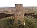
The Ordnance Survey triangulation station at Crow Knowl
-
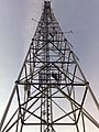
Crow Knowl Telecommunications Mast
-
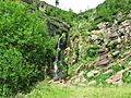
The waterfall at Pingot Quarry
-
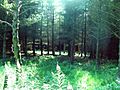
Trees in the dense forest in Crompton Moor
.jpg)


