Cubagua Island facts for kids
|
Native name:
Isla de Cubagua
|
|
|---|---|

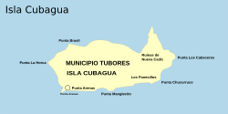
Map of Cubagua Island
|
|

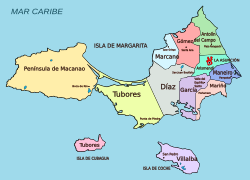
Cubagua Island within Nueva Esparta
|
|
| Geography | |
| Location | Caribbean Sea |
| Coordinates | 10°48′42″N 64°11′35″W / 10.81167°N 64.19306°W |
| Archipelago | Nueva Esparta |
| Highest elevation | 29 m (95 ft) |
| Administration | |
| Region | Insular |
| State | |
| Municipality | Tubores |
| Demographics | |
| Demonym | Cubaguense |
Cubagua Island, also known as Isla de Cubagua, is the smallest of the three islands that make up the Venezuelan state of Nueva Esparta. It's located in the Caribbean Sea, about 16 kilometers (10 miles) north of the Araya Peninsula on the mainland. The other two islands in Nueva Esparta are Margarita Island and Coche Island.
Contents
Geography of Cubagua Island
Island Shape and Size
Cubagua Island is shaped like an oval, measuring about 9.2 kilometers (5.7 miles) long and 3.6 kilometers (2.2 miles) wide. Its total area is about 22.4 square kilometers (8.6 square miles). The island has beaches and cliffs along its coast. The cliffs are about 5 to 7 meters (16 to 23 feet) high in the south and 20 to 24 meters (66 to 79 feet) high in the north. The highest point on the island is 32 meters (105 feet) above sea level.
Cubagua's Climate
Cubagua Island has a very dry climate, similar to a desert. It doesn't have any rivers or lakes. The only fresh water comes from small underground sources. The island gets very little rain, only about 250 millimeters (10 inches) per year. Temperatures stay around 25°C (77°F) all year, so it's always warm.
Plants on the Island
Because it's so dry, Cubagua Island has mostly desert-like plants, called xerophytes. These plants are specially adapted to live with very little water. You can find different types of cactus here, like Cardón de Dato, Buche, and Guamacho. There are also some plants from the pea family, such as Mesquite and Divi-divi.
Animals on the Island
The island is home to small groups of hares and wild goats. There is also a large population of dogs.
Getting Around Cubagua
Cubagua Island does not have any streets or roads. People travel around by boat. You can reach the island by ferry or other boats from Punta de Piedras on Margarita Island. The boat trip takes less than two hours. The main boat landing area is at Playa Charagato, which is the biggest settlement on Cubagua.
There are two lighthouses on Cubagua Island that help boats navigate. One is at Punta Charagato in the northeast, and another is at Punta Brasil in the northwest.
History of Cubagua Island
Early Settlements
People first visited Cubagua Island around 2325 BC, during a time known as the Meso-Indian Period. These early visitors didn't live on the island permanently. They came to gather oysters for food and, most importantly, for pearls. Because the island had no fresh water or much vegetation, it was hard for people to live there all the time.
Spanish Arrival and Pearl Trade
In 1498, Christopher Columbus saw Cubagua Island. A year later, in 1499, Spanish explorers returned to the island. They discovered many valuable pearl oysters. The Spanish forced the local people to dive for these pearls. Between 1508 and 1531, these pearls became one of the most important resources for the Spanish Empire in the Americas. However, this intense pearl harvesting greatly harmed both the local people and the oyster populations.
Nueva Cádiz: The First City
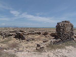
In 1528, a Spanish explorer named Cristóbal Guerra founded a city on Cubagua called Nueva Cádiz. This was the first settlement in Venezuela to be officially called a "city." Nueva Cádiz grew to have between 1,000 and 1,500 people. Sadly, the city was destroyed in 1541 by a powerful earthquake followed by a tsunami. Today, the ruins of Nueva Cádiz are a National Monument of Venezuela, declared so in 1979.
Administration
Cubagua Island is part of the Tubores municipality. This is one of the 11 municipalities in the state of Nueva Esparta.
Population Today
Even though people have visited Cubagua for thousands of years, very few people live there permanently today. This is still because of the lack of fresh water and plants. However, many fishermen from the Venezuelan mainland state of Sucre visit the island seasonally, meaning they stay for parts of the year. During these times, the population can go over 300 people.
According to a count in 2007, there were 51 permanent residents on the island, including 19 children. These residents live in four small communities in the northwest part of the island:
- Playa Falucho
- Playa Charagato (which is the largest community)
- Punta Charagato
- Punta la Cabecera (located near the old ruins of Nueva Cádiz)
There are also a few other small groups of buildings on the island, like at Punta Arenas in the southwest.
See also
 In Spanish: Isla de Cubagua para niños
- Cariaco Basin
 | Emma Amos |
 | Edward Mitchell Bannister |
 | Larry D. Alexander |
 | Ernie Barnes |


