Cumberland Homesteads facts for kids
Quick facts for kids |
|
|
Cumberland Homesteads Historic District
|
|
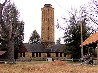
Homesteads Tower
|
|
| Location | Roughly along County Seat and Valley Rds., Grassy Cove Rd., Deep Draw and Pigeon Ridge Rds. |
|---|---|
| Nearest city | Crossville, Tennessee |
| Area | 10,250 acres (4,150 ha) |
| Built | 1934–1941 |
| Architect | William Macy Stanton |
| Architectural style | FSA small house |
| NRHP reference No. | 88001593 |
| Added to NRHP | September 30, 1988 |
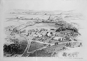
Cumberland Homesteads is a special community in Cumberland County, Tennessee, United States. It was started in 1934 during a tough time called the New Deal era. The government wanted to help farmers, coal miners, and factory workers who were struggling. They hoped this community would be a great example of people working together.
Even though the idea of everyone working together didn't quite last, the community itself kept going. In 1988, many of the original houses and buildings were added to the National Register of Historic Places. These buildings are special because they are made from a local stone called "crab orchard" sandstone.
In the early 1930s, many small farms in East Tennessee were not doing well. Also, the Great Depression meant thousands of workers had lost their jobs. In 1934, the government chose Cumberland County for a new kind of community. Families moved to small farms and were supposed to work in businesses owned by the community. Most of these shared businesses didn't succeed. After World War II, the government stopped being involved. However, the community still looks much like it did in the late 1930s.
Contents
Where is Cumberland Homesteads?
Cumberland Homesteads is in a hilly area on top of the Cumberland Plateau. It's just south of Crossville. A stream called Byrd Creek flows through the community. Cumberland Mountain State Park is also located here. This park was built around the same time as the Homesteads for fun and recreation.
You can reach the Homesteads area using U.S. Route 127. This road connects to Crossville and Interstate 40 to the north. State Route 68 (Grassy Cove Road) goes east to Grassy Cove. The historic area covers a huge space, over 10,000 acres (40 km2). It includes properties on many roads and even some buildings in Cumberland Mountain State Park.
How the Idea Started
In 1933, a new law called the National Industrial Recovery Act was passed. This law created a special government group and gave them money. Their job was to buy land and create small farming communities. These communities were for people who had lost their jobs.
A local farm agent named Robert Lyons helped create a plan for a homestead community. He sent this plan to the government in December 1933. The government liked the idea and approved the plan in January 1934. The Civil Works Administration quickly hired many local people to get the land ready. This work helped end the Great Depression in Cumberland County.
A talented architect named William Macy Stanton designed the houses and other buildings. He also designed buildings in the planned city of Norris. The Civilian Conservation Corps built fun places like recreational buildings and a small lake. This area is now Cumberland Mountain State Park. By late 1934, the first stone houses were finished.
What Was the Goal?
President Franklin D. Roosevelt had big hopes for this project. He wanted the homes to be comfortable. He also wanted the community to be like a perfect, ideal place. The government focused on three types of settlements. Some were for part-time farmers near jobs. Others were for farmers moving from bad land. The third type, like Cumberland Homesteads, was for "stranded" workers. These were often miners and loggers.
Some people worried that these communities for industrial workers would not be able to support themselves. However, Kelly Cox, who works at the Cumberland Homestead Tower Association, thinks the project was a success. She says people were desperate for work and a chance to build a life.
More than 20,000 acres (81 km2) of land south of Crossville was bought for the project. A group called Cumberland Homesteads, Inc. was created to manage everything.
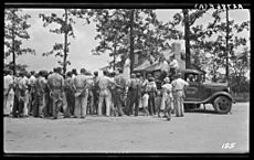
The first 233 families chosen for the project came from different backgrounds. About 30% were struggling farmers. Another 30% were unemployed miners. About 30% were textile workers without jobs. The last 10% were professionals like teachers and nurses.
How the Project Worked Out
A community-owned store, called the "Trading Post," and a cannery were started in 1934. But they had trouble because the people running them were new to it. The government hoped that companies would move to the Homesteads and offer jobs. This didn't happen. Attempts by the homesteaders to start a coal mine and a sorghum mill also failed.
Through the 1930s, different government groups managed the project. This meant the project didn't always have a clear plan. By 1945, the government let the homesteaders buy their farms. Then, the government left the project. Even though the original idea of the Homesteads didn't fully work, the community survived. More than half of the farms were still owned by the original families in the 1950s.
Stories from Local Historians
Today, the Cumberland Homestead Tower Association works hard to save the rich history of the project. Three people from the Tower Association shared their thoughts. They all agreed that the project gave people a great chance. Charles Tollett, a volunteer, said the Homesteads was not a "handout." Instead, it was a chance for people to work hard for a place to live. From the very beginning, when the land was cleared and homes were built, the community played a big role. Kelly Cox, the Museum Director, explained that some future residents worked to earn credit towards buying their homes.
Building Designs
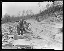
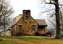
The people who created the community wanted to build with local materials. Buildings at Cumberland Homesteads were mostly made from "crab orchard" stone. This stone is found nearby and is known for being very strong. It also has a reddish color in the late afternoon sun.
The most famous building is the Homesteads Tower. It's a cross-shaped building with an eight-story water tower in the middle. This building used to hold the Homesteads offices and provided water. Now, it's home to the Cumberland Homestead Tower Association. They work to preserve the history of the program.
The elementary and high schools are behind the Tower. They have unique designs with separate classrooms and workshops. These are connected by covered walkways. Both school buildings are now part of Homestead Elementary School.
Homesteads Today
Most of the original 251 houses are still standing today. There were fifteen different house designs. Eleven of these designs were used many times. They followed basic plans made by William Macy Stanton. His designs included rectangular, L-shaped, and T-shaped houses. Most were 1.5 stories tall with gable roofs and one or two chimneys.
Most houses originally had covered porches and special "batten" doors. Inside, they often had pine paneling and built-in bookshelves. The attics held water tanks. Most houses were also ready for electricity from the TVA. Most farms included a barn, a smokehouse, a chicken house, and toolsheds.
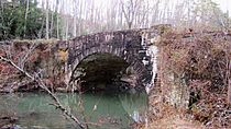
The Cumberland Homesteads Historic District also includes several structures at Cumberland Mountain State Park. These include the Byrd Creek Dam, Millhouse Lodge (which was once a gristmill), rustic cabins, and a stone water tower. The Byrd Creek Dam is the largest stone structure ever built by the Civilian Conservation Corps. Two stone arch bridges, one on Deep Draw Road and one on Old Mail Road, are also important parts of the historic district.
 | Lonnie Johnson |
 | Granville Woods |
 | Lewis Howard Latimer |
 | James West |


