Cymenshore facts for kids
Cymenshore is a place in Southern England. According to an old book called the Anglo-Saxon Chronicle, a king named Ælle of Sussex landed here in AD 477. He fought against the Britons with his three sons: Cymen, Wlencing, and Cissa. The place Cymenshore was supposedly named after his son Cymen. We don't know its exact location today, but it was probably somewhere near Selsey.
Contents
Uncovering the Past: Historical Clues
The story of Ælle and his sons arriving at Cymenshore comes from the Anglo-Saxon Chronicle. This was a collection of old manuscripts written in the 9th century. That's about 400 years after the events at Cymenshore supposedly happened!
The legend of how Saxon Sussex was founded by Ælle likely started as spoken stories. These stories were then written down in the Anglo-Saxon Chronicle. There isn't much written information from the time between 491 AD and when Christianity arrived in the 7th century.
What we know about early Sussex from the Chronicle has been updated. We now have more information from other parts of England and from archaeological discoveries. The Chronicle also mentions other battles. It describes a fight with the British in 485 AD near Mercredesburne. It also talks about a siege of Andredescester in 491 AD, where the people were killed. Andredescester is thought to be modern-day Pevensey.
Towards the end of the Roman rule in England, attacks on the east coast became more common. Roman-British leaders decided to ask Anglo-Saxon fighters for help. They gave these fighters land in return. Some historians believe these fighters might have started arriving in Sussex as early as the 5th century.
Archaeological finds, like old cemeteries, show where people settled in the 5th century. Most of these early Anglo-Saxon sites are in East Sussex. They are found between the lower River Ouse and River Cuckmere. This area might have been where Anglo-Saxon fighters were allowed to settle by agreement.
Some historians suggest that Ælle later tried to expand his territory. Around 465 AD, he fought the battle of 'Mearcredesburne'. One meaning of this name is 'river of the frontier agreed by treaty'. The Chronicle doesn't say who won this battle. But after taking Pevensey around 471 AD, Ælle's land reached the Pevensey Levels. East of the Levels, another group called the Haestingas settled independently. Their land was seen as separate from the rest of Sussex even in the 11th century. No pagan cemeteries have been found in this area. This suggests they might have been Christian when they arrived. In West Sussex, including Selsey and Chichester, there are very few early Anglo-Saxon archaeological finds.
What's in a Name: Etymology of Cymenshore
Even though there's no archaeological proof that Ælle existed or that he invaded, there is some language evidence for the name Cymensora. This is the place where the Anglo-Saxon Chronicle says he landed in 477 AD.
The word ora is only found in place names where certain old English dialects were spoken. These were mainly in southern England. It's possible that the low coastal area from Southampton to Bognor was called Ora, meaning "the shore." Different parts of this shore might have been named after local settlements. Examples include Ower near Southampton, Rowner near Gosport, and Itchenor.
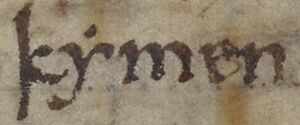
According to the Anglo-Saxon Chronicle, Cymensora was named after Cymen, one of Ælle's sons. So, the name would mean "Cymen's landing place" or "Cymen's shore."
Where Was Cymenshore: Possible Locations
The exact location of Cymenshore is not clear. However, several places have been suggested.
The Selsey Area
The Selsey area is the most popular idea for Cymenshore. This idea comes from two old documents called charters. These charters mention a place with a similar name in their boundary descriptions.
One charter describes land given to Wilfrid at Selsey in the 7th century by King Caedwalla. This document is actually a fake from the 10th century. However, it mentions "Cumeneshore" as a boundary point. It says: "from the entrance of the harbour which is called in English Wyderinges round where the sea falls back at Cumenshore then towards the western shore at Rumbruge..."
Another document, the Charter of Byrhthelm, is believed to be real. It talks about land taken from the See of Selsey. This charter confirms the boundary is "from Wytherings Mouth and Cymenshoran in the east to Hormouth in the west."
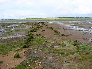
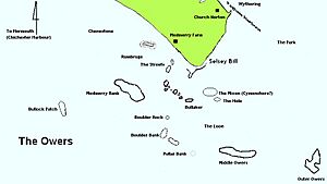
Rumbruge (also called "thri beorg" – three barrows) is now known as the Medmerry Bank. It was likely a small island and trading port off the southwest coast of the Manhood Peninsula. This area has since been lost to the sea. Wytherings mouth was part of what is now Pagham Harbour.
The Owers
Just off the tip of Selsey Bill, about 11 kilometers (7 miles) to the southeast, are groups of rocks and ledges called the Owers.
Some historians think the Outer Owers and Middle Owers were Ælle's landing place. However, this is unlikely. Studies show that this part of the Owers has not been part of the shoreline for at least 5,000 years. The Outer Owers are about 11 kilometers (7 miles) from Selsey Bill. The coastline would have been 2–3 kilometers (1–2 miles) further out to sea 5,000 years ago.
The Mixon
South of Selsey Bill are the Mixon rocks. It's thought that during the Iron Age, the Atrebates tribe built their main town (Oppidum) in the Selsey area. Some people think the Mixon could be the site of Cidade Celha (the Old City), and therefore Cymensora.
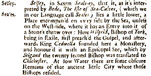
Archaeological evidence shows that the Mixon was part of the shoreline during the Roman period. The sea didn't break through it until the 10th or 11th century. As late as the 17th century, people reported seeing the remains of the "ancient little city" at low tide.
Keynor
The Manor of Keynor is located at the western end of Pagham Harbour. Some historians, like Edward Heron-Allen and Francis Mee, believe the Keynor area of Sidlesham was Cymenshore. They suggest that the name Keynor comes from Cymensora. However, other experts say that Keyn-or actually means "Cow-Shore" in Old English.
Pagham Harbour
Today, Pagham Harbour is a nature reserve. But in earlier times, it was a busy working harbor with three ports. One was at the western end (Sidlesham Mill), one at the harbor entrance (Charlton), and one on the Pagham side (Port of Wythering). The Port of Wythering was flooded by the sea in the 13th century. Eventually, the whole harbor filled with silt and could no longer be used by ships, except for small boats.
West Wittering
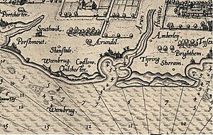
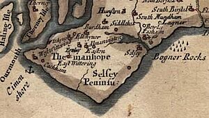
Some early mapmakers and historians thought West Wittering was the site of Cymenshore. For example, in his book Britannia, Camden wrote that Cimen landed at Cimonshore, a place near Wittering. Morden's map from 1695 also shows Cimenshore next to the Witterings.
However, other historians believe that placing Cymenshore off West Wittering was a mistake. They think it was probably due to a wrong translation of the old charter. The charter describes part of the land boundary as .. Wedering muðe.. (Wedering mouth). Wedering was the port of Withering, a village now lost, at the entrance to what is now Pagham Harbour. It's possible that earlier historians incorrectly translated Wedering as Wittering.
Other Possible Locations
Ouse-Cuckmere Area
Some historians believe that Cymenshore was more likely in the Ouse-Cuckmere area of East Sussex. Their reason is that there is no archaeological evidence to support a landing at Selsey. However, other experts point out that place names with the Old English word ora (like in Cymensora) are very common along the Hampshire and West Sussex coastline. They are not common around the Ouse-Cuckmere area. There's also a suggestion that the archaeology off the Selsey coast simply hasn't been fully explored yet.
Shoreham
Shoreham has also been suggested as a possible location. For example, in 1906, Hilaire Belloc wrote in his book Hills and the Sea that Ælle's ships sailed into Shoreham. He described it as a very difficult harbor, especially without piers and lights.
|
 | Shirley Ann Jackson |
 | Garett Morgan |
 | J. Ernest Wilkins Jr. |
 | Elijah McCoy |


