Cypress Peak facts for kids
Quick facts for kids Cypress Peak |
|
|---|---|

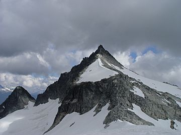
Cypress Peak, July 2005
|
|
| Highest point | |
| Elevation | 2,083 m (6,834 ft) |
| Prominence | 265 m (869 ft) |
| Listing | Mountains of British Columbia |
| Geography | |
| Parent range | Pacific Ranges |
| Topo map | NTS 092/J03 |
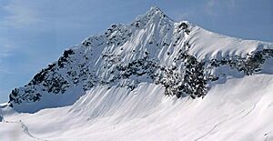
Cypress Peak is a special kind of mountain peak called a pyramidal peak. It's located in British Columbia, Canada, west of the town of Whistler. This mountain sits on a natural boundary, or "divide," between the Squamish River and the Cheakamus River.
The peak was named after a nearby stream, Cypress Creek. That stream is now known as Roe Creek, but the mountain kept its original name.
Understanding Cypress Peak's Climate
Cypress Peak is in a part of western North America that has a "marine west coast" climate. This means it gets a lot of rain and snow, especially in winter. It's like the weather you'd find near an ocean.
How Weather Affects the Mountain
Most of the weather for Cypress Peak comes from the Pacific Ocean. Large systems of air, called weather fronts, move east towards the Coast Mountains. When these fronts hit the tall mountains, the air is forced to rise. As the air goes higher, it cools down and drops its moisture as rain or snow. This process is called "orographic lift."
Because of this, the Coast Mountains, including Cypress Peak, get a lot of precipitation. In winter, temperatures can drop very low, sometimes feeling colder than −30 °C with the wind chill.
Best Time to Visit
If you wanted to climb Cypress Peak, the best time to go is usually from July through September. The weather during these months is much better and safer for outdoor activities on the mountain.


