Damascus, Oregon facts for kids
Quick facts for kids
Damascus
|
|
|---|---|
| Damascus, Oregon | |

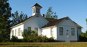
Old Damascus schoolhouse
|
|

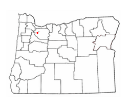
Location in Oregon
|
|
| Country | United States |
| State | Oregon |
| County | Clackamas |
| Incorporated | 2004 |
| Area | |
| • Total | 16.14 sq mi (41.80 km2) |
| • Land | 16.04 sq mi (41.54 km2) |
| • Water | 0.10 sq mi (0.26 km2) |
| Elevation | 712 ft (217 m) |
| Population
(2020)
|
|
| • Total | 11,050 |
| • Density | 657.0/sq mi (253.7/km2) |
| Time zone | UTC-8 (Pacific) |
| • Summer (DST) | UTC-7 (Pacific) |
| ZIP codes |
97009, 97015, 97030, 97080, 97089
|
| Area code(s) | 503 and 971 |
| GNIS feature ID | 2410292 |
Damascus /dəˈ[unsupported input]skɪs/ is a place in Clackamas County, Oregon, United States. It is called a census-designated place, which means it's an area identified by the U.S. Census Bureau for statistical purposes.
Damascus was first settled in 1867. For a while, it was even a city! It became a city in 2004 so that local people could make decisions about how their land was used. However, the residents later voted to stop being a city in 2016. After some legal discussions, it officially became an unincorporated area again in 2020.
Today, Damascus is located east of Happy Valley and west of Boring. In 2020, about 11,050 people lived there.
Contents
History of Damascus
Early Days and Post Office
The community of Damascus began around 1867. This is when a post office with the name "Damascus" was first opened. The post office helped people send and receive mail. It stayed open until 1904. The original center of the community was along Oregon Route 212. This road was part of the city's southern border later on.
Becoming a City
In 2000, a group called Metro decided to expand Portland's urban growth boundary. This boundary helps control how cities grow. Because of this decision, some people in Damascus wanted their community to become a city. They wanted to make sure they had control over their own land use.
So, in November 2004, the people voted on a special measure. This vote led to Damascus becoming an official city. It also included the nearby community of Carver. Becoming a city helped stop bigger cities from taking over their land. Damascus was the first new city in Oregon in 22 years!
City Life and Disincorporation
In 2005, people in Damascus voted again. They approved a city charter, which is like a rulebook for how the city would run. About 88% of voters said yes. Some areas between Damascus and Happy Valley also voted to join Damascus. Most of these areas decided to become part of the new city.
However, being a city was not always easy for Damascus. Over eight years, the city had seven different city managers. There were often disagreements about how things should be run. In 2013, some residents even voted to stop being a city and to remove the mayor.
In 2016, the citizens of Damascus voted a second time to stop being a city. This time, the idea was approved. It seemed like the city would no longer exist starting July 18, 2016.
Legal Challenges and Final Decision
But the story didn't end there! In 2019, a court said that the vote was not valid. This was because not enough people had voted in the election. So, for a while, Damascus was a city again.
Finally, in September 2020, the Oregon Supreme Court made a new decision. They said that the 2016 vote to stop being a city was valid after all. This meant that Damascus officially stopped being a city. What was once the City of Damascus is now an unincorporated area. This means it is managed by Clackamas County instead of its own city government.
Geography of Damascus
Location and Elevation
Damascus is located in the north-central part of Clackamas County. It sits about 712 feet (217 m) (217 meters) above sea level. The northern border of the former city was the line for Multnomah County. To the east of Damascus is Boring, and to the west is Clackamas.
Area Size
The United States Census Bureau measures the size of places like Damascus. They reported that the total area of the former city was about 16.14 square miles (41.80 km2). Most of this area, about 16.04 square miles (41.54 km2), was land. A small part, about 0.10 square miles (0.26 km2), was water.
Demographics
| Historical population | |||
|---|---|---|---|
| Census | Pop. | %± | |
| 2000 | 9,022 | — | |
| 2010 | 10,539 | 16.8% | |
| 2020 | 11,050 | 4.8% | |
| U.S. Decennial Census | |||
Population Information
The word "demographics" means facts about a population, like how many people live somewhere and what they are like. The United States Census Bureau collects this information every ten years.
In 2010, there were 10,539 people living in Damascus. These people lived in 3,621 households, which are like homes or apartments. About 2,984 of these households were families. The population density was about 657.0 inhabitants per square mile (253.7/km2). This means there were about 657 people for every square mile.
Diversity and Age
Most people in Damascus in 2010 were White (91.3%). There were also people from other backgrounds, including Asian (3.4%), African American (0.6%), and Native American (0.6%). About 4.4% of the population was Hispanic or Latino.
The average age in Damascus was 43.2 years old.
- About 25% of residents were under 18 years old.
- About 6.8% were between 18 and 24 years old.
- About 20.6% were between 25 and 44 years old.
- About 34.2% were between 45 and 64 years old.
- About 13.3% were 65 years old or older.
The population was almost evenly split between males (50.8%) and females (49.2%).
See also
 In Spanish: Damascus (Oregón) para niños
 | DeHart Hubbard |
 | Wilma Rudolph |
 | Jesse Owens |
 | Jackie Joyner-Kersee |
 | Major Taylor |

