Dareton, New South Wales facts for kids
Quick facts for kids DaretonNew South Wales |
|
|---|---|

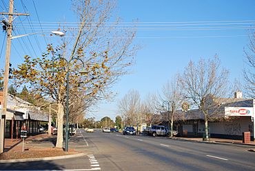
Tapio Ave, the main street of Dareton
|
|
| Population | 501 (2016 census) |
| Established | 1922 |
| Postcode(s) | 2717 |
| Location | |
| LGA(s) | Wentworth Shire |
| State electorate(s) | Murray |
| Federal Division(s) | Farrer |
Dareton is a small town in the far west of New South Wales, Australia. It's about 1,025 kilometres west of Sydney, the state capital. The town is also quite close to Mildura in Victoria, only 20 kilometres away. Dareton is part of the Wentworth Shire local government area. In 2011, about 516 people lived there.
This town sits right on the Murray River. It's a key part of the Coomealla Irrigation Area, where water is used to help farms grow crops. Did you know that Australian Test cricket captain Mark Taylor lived in Dareton when he was younger?
Discovering Dareton's Past

Dareton started to form in 1922. This was when people suggested using irrigation to grow crops in the area. Irrigation means bringing water to dry land to help plants grow. Early settlers moved here soon after.
However, Dareton really began to grow after World War II. This was when "soldier settler" farms were set up. These farms were given to soldiers returning from the war. The town is named after Henry Dare. He was a commissioner who strongly supported the irrigation plan.
Dareton Today: Farming and Fun
Today, Dareton is known for growing grapes and making dried fruit. It's a great place for outdoor activities. You can find a championship golf course here. It's also a popular spot for fishing and camping by the river.
A big part of the community is the Coomealla Memorial Sporting Club. This club has a large social area and offers many sports facilities. This includes the golf course. The club has always been popular with visitors from nearby states.
Dareton has several schools for students. These include Dareton Public School and Coomealla High School. There is also the Coomealla Campus of the Riverina Institute.
 | James Van Der Zee |
 | Alma Thomas |
 | Ellis Wilson |
 | Margaret Taylor-Burroughs |


