
Darwin Harbour facts for kids

Darwin Harbour is a large body of water located near the city of Darwin in the Northern Territory of Australia. It opens up to the north into the Beagle Gulf, a larger bay. It also connects to the Van Diemen Gulf through the Clarence Strait. Inside Darwin Harbour, you'll find Port Darwin, which is an important port. It has two smaller bays: Frances Bay on the east and Cullen Bay on the west.
Contents
How Darwin Harbour Got Its Name
Darwin Harbour was named after a famous scientist and explorer named Charles Darwin. He traveled the world on a ship called HMS Beagle. The ship's captain was Robert FitzRoy.
Even though the harbour is named after him, Charles Darwin and Robert FitzRoy never actually saw it! In 1836, they sailed from King George's Sound in Western Australia directly to the Cocos (Keeling) Islands. From there, they went to Cape Town and then back to England. They were about 3,000 sea miles away from Darwin Harbour and didn't know it existed.
Weather in Darwin Harbour
The Darwin Harbour area has a special kind of tropical weather called a monsoon climate. This means it has two very clear seasons: the Dry season and the Wet season.
The Dry season lasts for six months, from April to September. During this time, there's very little rain, only about 24 millimeters on average each month. The Wet season is from October to March, and it gets a lot more rain, about 254 millimeters per month! Most of the rain falls between December and April.
Rivers like the Blackmore River and Elizabeth River flow into the harbour. They have the most water in February, then the flow slowly decreases. By July, there's no fresh water flowing into the harbour until the next Wet season begins. Big storms called cyclones don't happen very often here.
Amazing Marine Life
Darwin Harbour is home to a huge variety of fish, with 415 different species known to live there! It's also a special place where you might see dugongs in the wild. Dugongs are gentle sea mammals, and they love to eat the seagrass found off Casuarina and Vestey’s beaches.
Seagrass meadows are very important. They are the main food for green turtles and provide a home for many smaller marine animals. This includes important animals like prawns and various types of fish that people catch.
The Ocean Around Darwin Harbour
Water Movement
The tides at Port Darwin are very big. The water level can change by as much as 7.8 meters between high and low tide! This big change in water level creates strong and complex currents in the harbour.
River Valleys

Darwin Harbour was formed a long time ago when a river valley was flooded by the sea. This creates a special type of coastline with many inlets and headlands.
Land Around the Harbour
The land area that drains water into Darwin Harbour is about 3,230 square kilometers. About 2,010 square kilometers of this is land, and the other 1,220 square kilometers are the water areas of the harbour itself at high tide.
Rocks Underneath
The ground beneath Darwin Harbour is mostly made up of rocks called siltstones and sandstones. These rocks formed a very long time ago during a period called the Permian.
How Darwin Harbour is Managed
On April 4, 2007, the part of Darwin Harbour that wasn't already part of a town or suburb was officially named a "locality" by the Northern Territory Government. This new area is also called Darwin Harbour.
Its northern boundary matches the boundary of the Port of Darwin, stretching from Charles Point in the west to Lee Point in the east. This locality is not part of any local government area like the City of Darwin or the Litchfield Municipality. Instead, it's considered part of the Northern Territory's "unincorporated areas," meaning the territory government directly manages it.
Images for kids
-
USS Peary sinking after the Japanese attack.
-
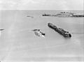
A sunken ship (MV Neptuna) and burnt-out wharf in Darwin Harbour following the attack on Darwin (AWM 027334)
_burning_at_Darwin_1942.jpg)
.jpg)
