Deception Falls facts for kids
Quick facts for kids Deception Falls |
|
|---|---|

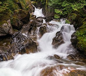
Deception Falls flow in the Summer
|
|
| Lua error in Module:Infobox_mapframe at line 185: attempt to index field 'wikibase' (a nil value). | |
| Location | King County, Washington |
| Coordinates | 47°42′52″N 121°11′40″W / 47.71444°N 121.19438°W |
| Type | Steep Cascade |
| Total height | 1,856 ft (566 m) |
| Number of drops | 3 |
| Longest drop | 86 ft (26 m) |
| Watercourse | Deception creek |
| Average flow rate |
200 cu ft/s (5.7 m3/s) |
Deception Falls is a beautiful waterfall in the state of Washington, USA. It is about 94 feet (29 meters) tall. This amazing waterfall gets its water from Deception Creek. It is located near Stevens Pass, which is a mountain pass. The falls are about 1,856 feet (566 meters) above sea level.
After flowing over the falls, Deception Creek soon joins the Tye River. Sometimes, in the late summer, the water flow might slow down. But the trail to Deception Falls stays open during the summer and fall. You can find Deception Falls north of Interstate 90 in the Mount Baker–Snoqualmie National Forest. There is a hiking trail that takes you right from a parking area to see the falls.
Where is Deception Falls Located?
Deception Falls is found in the Stevens Pass area, which is in Northwest Washington. It is not far from the famous Pacific Crest Trail. This trail is a very long hiking path that goes through mountains.
Nearby Waterfalls and Access
There are two other waterfalls upstream from Deception Falls that do not have names. Also, several other falls like Alpine Falls, Log Choke Falls, and Monkey Cage Falls are located downstream, closer to the Tye River.
The waterfalls are located along Highway 2. Deception Falls is about 8.5 miles (13.7 kilometers) east of a small town called Skykomish, Washington. It is also the same distance west of the Stevens Pass ski resort. You can get to the falls by using the Deception Creek Trailhead. This trailhead is off Forest Road 6088, which connects to U.S. Route 2.
 | Jackie Robinson |
 | Jack Johnson |
 | Althea Gibson |
 | Arthur Ashe |
 | Muhammad Ali |

