Dee Wright Observatory facts for kids
Quick facts for kids Dee Wright Observatory |
|
|---|---|

Observatory at the summit of McKenzie Pass
|
|
| Location | McKenzie Pass, Lane County, Oregon, United States |
| Created | 1935 |
| Operated by | U.S. Forest Service |
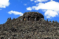
The Dee Wright Observatory is a special building high up in the Cascade Mountains of Oregon. It's like an open shelter made from lava rock. This unique spot sits right in the middle of a huge lava flow. From here, you can see amazing views of many tall mountains in the Cascade Range.
Contents
Exploring Dee Wright Observatory
Where is the Observatory Located?
The Dee Wright Observatory is found in the Willamette National Forest. It's about 15 miles (24 km) west of a town called Sisters, Oregon. You can reach it by driving on Route 242. This road is part of the beautiful McKenzie-Santiam Pass Scenic Byway.
McKenzie Pass is very high up, at 5,325 feet (1,623 meters) above sea level. Because of heavy winter snow, the road to the observatory closes to cars from November to July each year. Sometimes, during these closed months, cyclists can still ride their bikes on the road.
What Makes the Observatory Special?
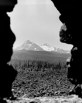
The observatory is an open shelter built using lava rock found right there. It's made from a type of lava called basaltic andesite. What's really cool are the viewing windows. They are cut in a special way to frame the nearby mountains perfectly. These "lava tube" viewing holes help you easily spot and name the different Cascade peaks.
On the roof, there's a large bronze "peak finder" that is 36 inches (90 cm) wide. It's like a compass that helps you find mountains and other cool land features. From the top of the observatory, you get a wide, sweeping view of the Cascade Mountain Range. On a clear day, you can even see Mount Hood far to the north!
Many famous peaks are visible from Dee Wright Observatory. These include Mount Jefferson, Black Butte, Black Crater, North Sister, Middle Sister, and Mount Washington. Other peaks like Cache Mountain, Dugout Butte, and Belknap Crater can also be seen.
Walking the Lava River Trail
Right at the observatory, you can start a half-mile long path called the Lava River Interpretive Trail. This trail takes you on a 30-minute walk through the ancient lava beds. It's paved and easy to follow. Along the way, signs explain the geology of the area. The trail also offers open views of the amazing landscape around you.
History of Dee Wright Observatory
A Road Through Lava
The path that McKenzie Pass follows today was once an old wagon route from the 1860s. This route came out of the forest and crossed a huge lava flow, covering 65 square miles (168 square kilometers). Building a road through these lava beds was very hard work. Because of this, most early travelers used other routes over the Cascades. Today's highway still follows that old wagon route past the observatory site.
Built by Young Workers
The Dee Wright Observatory was built during the Great Depression. This was a time in the 1930s when many people didn't have jobs. A group of young men from the Civilian Conservation Corps (CCC) built it. They worked at a place called Camp Belknap, near Clear Lake.
The observatory was finished in 1935. It was named after the foreman, or leader, of the construction crew. His name was Dee Wright. He had worked for the Forest Service for 24 years, helping with supplies and leading crews. Sadly, he passed away the year before the observatory was completed.
Today, the United States Forest Service takes care of the observatory and the old timber shelter at Camp Belknap. Thousands of people visit Dee Wright Observatory every summer to enjoy the views and learn about the area.
 | Anna J. Cooper |
 | Mary McLeod Bethune |
 | Lillie Mae Bradford |


