Deepcar facts for kids
Quick facts for kids Deepcar |
|
|---|---|
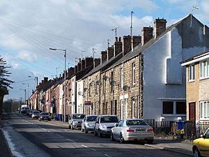
 Houses along Manchester Road |
|
| OS grid reference | SK285975 |
| Metropolitan borough | |
| Metropolitan county | |
| Region | |
| Country | England |
| Sovereign state | United Kingdom |
| Post town | SHEFFIELD |
| Postcode district | S36 |
| Dialling code | 0114 |
| Police | South Yorkshire |
| Fire | South Yorkshire |
| Ambulance | Yorkshire |
| EU Parliament | Yorkshire and the Humber |
| UK Parliament |
|
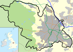
Deepcar is a small village in South Yorkshire, England. It is located on the eastern edge of the town of Stocksbridge. You can find Deepcar about 7 miles (11 km) northwest of Sheffield city centre. It is part of the Stocksbridge and Upper Don area.
Where is Deepcar?
Deepcar is located where two rivers meet: the River Don and the Little Don River. It is also close to where two main roads, the A616 and A6102, connect.
For many years, Deepcar had its own railway station. This station was open from 1846 to 1959. It was part of a railway line called the 'Woodhead Line', which connected Sheffield to Penistone. Another private railway, the Stocksbridge Railway, also joined here.
Deepcar's History
Deepcar has a very long history, going back thousands of years!
Ancient Discoveries
In 1962, archaeologists found an ancient site in Deepcar. This site included what might have been a very old house. It dates back to the Mesolithic period, which was a time when people were hunter-gatherers. This period was between the Stone Age and the New Stone Age.
The tools found at Deepcar are similar to those found at another famous site called Star Carr in North Yorkshire. The unique small stone tools found here are even called "Deepcar type assemblages" by archaeologists. This shows how important the discoveries at Deepcar were!
Archaeologists have also found signs of a possible Romano-British settlement near the river banks. This means people might have lived here during the time of the Roman Empire.
Modern Deepcar
The local church, called St John the Evangelist, was built and opened in 1878. It has been an important part of the village community ever since.
 | Jackie Robinson |
 | Jack Johnson |
 | Althea Gibson |
 | Arthur Ashe |
 | Muhammad Ali |


