Degilbo facts for kids
Quick facts for kids DegilboQueensland |
|||||||||||||||
|---|---|---|---|---|---|---|---|---|---|---|---|---|---|---|---|

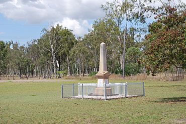
War memorial
|
|||||||||||||||
| Population | 182 (2021 census) | ||||||||||||||
| • Density | 1.940/km2 (5.02/sq mi) | ||||||||||||||
| Postcode(s) | 4621 | ||||||||||||||
| Area | 93.8 km2 (36.2 sq mi) | ||||||||||||||
| Time zone | AEST (UTC+10:00) | ||||||||||||||
| Location |
|
||||||||||||||
| LGA(s) | North Burnett Region | ||||||||||||||
| State electorate(s) | Callide | ||||||||||||||
| Federal Division(s) | Flynn | ||||||||||||||
|
|||||||||||||||
Degilbo is a small country town and area in the North Burnett Region of Queensland, Australia. In 2021, about 182 people lived in Degilbo. It's a quiet place with a rich history.
Contents
Discovering Degilbo's Past
How Degilbo Got Its Name
The name Degilbo first appeared in 1847. It was the name of a large farm, or "pastoral run," owned by William Henry Walsh. Many people believe the name comes from an Aboriginal phrase, dackeel bo. This phrase means sharp or upright stones.
There's also a fun story about the name. Some say a railway surveyor, who had to name many stations, ran out of ideas. He felt obliged to find a name, so he wrote that word backwards. This story is often shared, but the farm was named Degilbo long before the railway was built. So, the Aboriginal origin is more likely!
Early Services and Schools
The first post office in Degilbo opened on 1 April 1893. It changed its name a few times before becoming Degilbo again in 1898. It finally closed in 1958.
Degilbo State School opened in 1894 as Woowoonga Provisional School. It became Degilbo State School in 1908. Sadly, with only 11 students, the school closed its doors in 2008. It was located at 598 Gooroolba Road.
Another school, Woowoonga Creek Provisional School, opened in 1898 but closed in 1909. Mount Appallan State School also taught students from 1902 to 1953.
Remembering History: The War Memorial
The Degilbo War Memorial was officially revealed on 17 September 1922. It honors the brave people from the area who served and died in World War I. You can find this important memorial next to the Isis Highway.
The Bicentennial National Trail
The Bicentennial National Trail is a very long track for walking, cycling, and horse riding. It passes right through Degilbo. This trail stretches for thousands of kilometers across eastern Australia.
Who Lives in Degilbo?
Degilbo is a small community. In 2021, the area had a population of 182 people. This number can change a bit over the years. For example, in 2011, there were 338 people, and in 2016, there were 174.
Important Historical Places
Degilbo has several places listed for their historical importance. These are called heritage-listed sites. They help us remember the past.
- Deep Creek Railway Bridge: This bridge is part of the old Mungar-Monto railway line. It's about 6 kilometers west of Degilbo.
- Degilbo Hall: Located on Exhibition Street, this hall has been a community meeting place for many years.
- Degilbo Cemetery: You can find this historic cemetery on Seccombes Road.
In 2016, a special marker was placed to recognize the Degilbo-Mundubbera Railway Bridges. This marker celebrates 12 bridges on the Mungar to Mundubbera rail line. They are considered some of the best historic railway bridges in Australia.
Learning in Degilbo
There are no schools directly in Degilbo today. For primary school, kids usually go to nearby towns like Biggenden or Dallarnil. For high school, students can attend schools in Biggenden (up to Year 10) or travel to Gayndah and Childers (for all years up to Year 12).
 | Victor J. Glover |
 | Yvonne Cagle |
 | Jeanette Epps |
 | Bernard A. Harris Jr. |


