Del Aire, California facts for kids
Quick facts for kids
Del Aire, California
|
|
|---|---|
 |
|

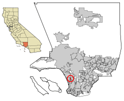
Location of Del Aire in Los Angeles County, California.
|
|
| Country | |
| State | |
| County | |
| Area | |
| • Total | 1.01 sq mi (2.61 km2) |
| • Land | 1.01 sq mi (2.61 km2) |
| • Water | 0.00 sq mi (0.00 km2) 0% |
| Elevation | 102 ft (31 m) |
| Population
(2020)
|
|
| • Total | 10,338 |
| • Density | 10,255.95/sq mi (3,958.61/km2) |
| Time zone | UTC-8 (PST) |
| • Summer (DST) | UTC-7 (PDT) |
| ZIP code |
90250 & 90304
|
| Area code(s) | 310/424 |
| FIPS code | 06-18352 |
| GNIS feature IDs | 1867012, 2408648 |
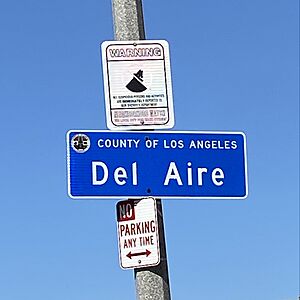
Del Aire (which means "Of The Air" in Spanish) is a community in Los Angeles County, California. It's a special kind of place called a census-designated place (CDP). This means it's not an official city, but the government counts its population separately.
Del Aire is located in the inland South Bay, Los Angeles area. It sits between the cities of El Segundo and Hawthorne. In 2020, about 10,338 people lived there.
This small neighborhood is mostly residential. It's right next to where two big highways, Interstate 405 and Interstate 105, meet. Del Aire is made up of two main parts. One part is to the northwest, bordered by I-105 and the city of Los Angeles. The other part is to the southeast, surrounded by Hawthorne. A small strip of land connects these two areas.
The Los Angeles Airport Courthouse is located within Del Aire. Also, the Aviation/LAX station for the Metro C Line light rail is very close by. The Los Angeles Air Force Base is also next to Del Aire, in El Segundo.
Contents
Geography
Del Aire is located in California at coordinates 33°54′58″N 118°22′9″W.
The United States Census Bureau says that Del Aire covers about 1.0 square mile (2.6 square kilometers) of land. There is no water area within its boundaries.
The exact borders of Del Aire can be a bit tricky. Generally, it's the area south of Imperial Highway. This area is between Aviation Boulevard and the San Diego Freeway (I-405). It extends down to El Segundo Boulevard. Del Aire also includes an area east of the freeway. This part is west of Inglewood Avenue, roughly between El Segundo Boulevard and Rosecrans Avenue. This section is sometimes called "Wiseburn" by L.A. County.
Education
All students living in Del Aire attend schools in the Wiseburn Unified School District. This district serves students from kindergarten through high school.
Schools located right in Del Aire include:
- Juan De Anza Elementary, for students in kindergarten through 5th grade.
- Da Vinci Design Charter School, for high school students in grades 9-12.
Other schools in the Wiseburn School District are just south of Del Aire. These are in the nearby Hawthorne community called Holly Glen. They include Juan Cabrillo Elementary, 138th Street Elementary, Richard Henry Dana Middle School, and Da Vinci Science Charter School.
The Wiseburn Unified School District became a unified district in 2014. This means it now covers all grades, from elementary to high school. Before 2014, high school students from Del Aire went to schools in the Centinela Valley Union High School District. In 2021, some nearby areas voted to join the Wiseburn USD. This made it easier for students in those areas to attend Wiseburn schools.
Population Information
The number of people living in Del Aire has changed over the years.
| Historical population | |||
|---|---|---|---|
| Census | Pop. | %± | |
| 1970 | 11,930 | — | |
| 1980 | 8,487 | −28.9% | |
| 1990 | 8,040 | −5.3% | |
| 2000 | 9,012 | 12.1% | |
| 2010 | 10,001 | 11.0% | |
| 2020 | 10,338 | 3.4% | |
| U.S. Decennial Census | |||
2020 Population
In 2020, Del Aire had a population of 10,338 people. The community is quite diverse. About 30.95% of the people were White (not Hispanic). Around 4.68% were Black or African American. About 10.23% were Asian. A large group, about 47.18%, identified as Hispanic or Latino (who can be of any race).
There were about 3,291 households in Del Aire. Many households, about 37.1%, had children under 18 living there. The average household had about 3.04 people. Most homes, about 68.9%, were owned by the people living in them. The rest were rented.
2010 Population
The 2010 United States Census counted 10,001 people in Del Aire. The population density was about 9,864 people per square mile.
About 23.3% of the population was under 18 years old. About 10.6% were 65 years or older. The median age in Del Aire was 36.0 years. This means half the people were younger than 36, and half were older.
Community Services
The Los Angeles County Sheriff's Department helps keep the community safe. They operate the South Los Angeles Station, which serves Del Aire.
See also
 In Spanish: Del Aire para niños
 | Dorothy Vaughan |
 | Charles Henry Turner |
 | Hildrus Poindexter |
 | Henry Cecil McBay |


