
Delano, Wichita, Kansas facts for kids
Quick facts for kids
Delano
|
|
|---|---|

The Delano Clock Tower (2012)
|
|
| Country | United States |
| State | Kansas |
| County | Sedgwick |
| City | Wichita |
| Platted | 18?? (Elgin) 1871 (Delano) 1880 (West Wichita) |
| Elevation | 1,299 ft (396 m) |
| Population
(2016)
|
|
| • Total | 5,479 |
| Demonym(s) | Delanonians |
| ZIP code |
67203, 67213
|
| Area code | 316 |
Delano is a cool neighborhood in Wichita, Kansas, in the United States. It's a mix of shops, restaurants, and homes located on the west side of the Arkansas River. Delano is home to some awesome places like Friends University, Riverfront Stadium, and Exploration Place, which is a super fun science museum for Sedgwick County.
Contents
Discover Delano's Past
Settlers first came to this area because land was cheap, thanks to the Homestead Act of 1862. They built their homes across the Arkansas River from Wichita, Kansas and called their new community Elgin.
How Delano Became a Cowtown
In 1870, Elgin became an important stop on the Chisholm Trail. This was a famous route where cowboys drove cattle. The town started to grow quickly. In March 1871, people living there decided to change the town's name to Delano. They named it after Columbus Delano, who was the Secretary of the Interior for President Ulysses S. Grant.
Over the next two years, many new businesses opened. These included hotels, saloons, and other fun spots. A post office and a toll bridge to Wichita also opened. Delano was known as a lively place with lots of entertainment for cowboys.
In the late 1870s, the cattle trade moved west to Dodge City. This meant Delano's time as a busy cowtown ended.
Becoming Part of Wichita
Wichita officially took over Delano in 1880. After this, the area became known as West Wichita. A few years later, the economy grew, and many new homes were built. Streets were named after important early settlers. New businesses opened, including a watch factory.
Friends University first opened in Delano in 1887, though it was called Garfield University back then. However, by the end of the 1880s, the city faced tough economic times, and many people struggled financially.
Growth and Aircraft Industries
Things started to pick up again in the early 1900s. Manufacturing and the oil industry began to grow. In the 1920s, Wichita became a major center for building airplanes. Several aircraft companies opened in Delano. These included Travel Air in 1925 and Cessna in 1927. Smaller companies like Wichita Blue Streak Motor Company also set up shop. By the 1930s, most of Delano was made up of homes built in the previous 30 years.
Changes to the River and New Landmarks
In the early 1930s, a sandbar called Ackerman Island in the middle of the Arkansas River was moved. It became part of the west bank of the river. A baseball stadium on Ackerman Island was taken down. So, a new baseball field, Lawrence Athletic Field, was built in Delano. This field, later known as Lawrence–Dumont Stadium, opened in 1934.
That same year, the city built the Ben F. McLean Memorial Fountain in Delano. It was built to remember Ben F. McLean, who used to be the mayor.
Modern Delano: Revitalization
In the 1950s and 60s, many businesses started to leave Delano. The aircraft industry also moved to other parts of the city. By the 1990s, the area was a bit quieter.
But in 1999 and 2000, local groups and the city government worked together. They created a plan to make Delano better. This plan included improving roads and encouraging new businesses. Since then, Delano's business area has become a popular spot for shopping and entertainment. It's now known as the Historic Delano District.
Where is Delano Located?
Delano is found at 37°40′58″N 97°21′35″W / 37.68278°N 97.35972°W. It's about 1,299 feet (396 meters) above sea level. The Arkansas River forms its northern and eastern edges. U.S. Route 54 is its southern border, and Meridian Avenue is its western border.
Delano is right across the river from Downtown Wichita. It shares borders with the McCormick neighborhood to the south and Sunflower to the west. Riverside is across the river to the north.
Learning in Delano
Delano has great options for students of all ages.
Schools for Younger Students
Wichita Public Schools runs two schools in Delano:
- Allison Traditional Magnet Middle School
- Franklin Elementary School
The Roman Catholic Diocese of Wichita also has a Catholic elementary school here:
- St. Joseph School
For older students, there's:
- Northfield School of the Liberal Arts, which teaches grades six through twelve.
Colleges and Universities
The main campus of Friends University is located in Delano. It's a private Christian university.
Libraries for Everyone
The Advanced Learning Library is the main library for the Wichita Public Library. You can find it on West Second Street in Delano.
Fun and Games: Parks and Recreation
The Wichita Department of Park and Recreation takes care of three parks in Delano:
- Delano Park: This is a small park right on the west bank of the Arkansas River. It's where McLean Boulevard and Douglas Avenue meet. Here, you can find a historical marker showing where the Chisholm Trail used to be. There's also a cool lighted fountain honoring Ben F. McLean, a former mayor of Wichita.
- Seneca Park: This is a 2-acre (0.81 ha) neighborhood park on South Seneca Street. It has tennis courts and a playground, perfect for playing outside.
- West Side Athletic Field: This large 24.83-acre (10.05 ha) field on North McLean Boulevard has tennis courts and baseball fields that are open for everyone to use.
Cool Places to Visit
Delano has some exciting spots that are worth checking out:
- Delano Clock Tower
- Exploration Place (a science museum!)
- Riverfront Stadium (where you can watch baseball)
- Wichita Ice Center (for ice skating fun)
Getting Around Delano
Douglas Avenue is the main street that runs east-west through Delano. Seneca is the main street running north-south. Other important roads include:
- Maple Street (east-west, south of Douglas)
- Meridian Avenue (north-south, on the western edge)
- McLean Boulevard (runs along the Arkansas River's west bank)
U.S. Route 54 is a freeway that runs along the southern edge of Delano. You can get on and off it at Sycamore Street, Seneca, and Meridian.
Public Transportation
Several Wichita Transit bus routes serve Delano, including routes 11, 12, 14, and 15. The free Q-Line trolley also runs through the neighborhood on its Delano/Old Town and Douglas routes.
Train Lines
The Kansas and Oklahoma Railroad operates a freight train line that goes through Delano. It enters from the northwest and leaves to the southwest.
Images for kids
-

Exploration Place science museum (2013)
-
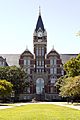
University Hall at Friends University (2012)
-
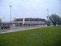
Lawrence-Dumont Stadium (2009)
-
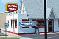
The original Nu Way Cafe (2007)


_in_Wichita,_Kansas.jpg)
