Delmont, Pennsylvania facts for kids
Quick facts for kids
Delmont, Pennsylvania
|
|
|---|---|
|
Borough
|
|

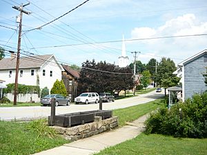
Historic water trough on East Pittsburgh Street in Delmont
|
|

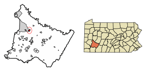
Location of Delmont in Westmoreland County, Pennsylvania (left) and of Westmoreland County in Pennsylvania (right)
|
|
| Country | United States |
| State | Pennsylvania |
| County | Westmoreland |
| Settled | 1814 |
| Incorporated | 1833 |
| Government | |
| • Type | Borough Council |
| Area | |
| • Total | 1.06 sq mi (2.73 km2) |
| • Land | 1.06 sq mi (2.73 km2) |
| • Water | 0.00 sq mi (0.00 km2) |
| Elevation | 1,260 ft (380 m) |
| Population
(2020)
|
|
| • Total | 2,596 |
| • Density | 2,458.33/sq mi (949.19/km2) |
| Time zone | UTC-5 (Eastern (EST)) |
| • Summer (DST) | UTC-4 (EDT) |
| Zip Code |
15626
|
| FIPS code | 42-18768 |
| Website | Delmont's website |
Delmont is a small town, also called a borough, in Westmoreland County, Pennsylvania. In 2020, about 2,592 people lived there. It is known for its history as a busy stop for travelers and for where two major roads meet.
Contents
Delmont's History
Delmont was first known as New Salem. A man named William Wilson received the land in 1784. When he arrived in 1785, he named the area New Salem. In 1812, a post office opened in New Salem, called "Salem X Roads" or "Salem Crossroads." Hugh Bigham was the first postmaster.
After William Wilson passed away in 1796, his land was divided between his sons. Later, his son Thomas became the only owner. Thomas divided the land into 48 lots to create a crossroads village. He designed the town around a watering trough built in 1810 by Hugh Bigham. This watering trough was connected to a spring that never ran dry. In 1814, the 48 lots were sold to form the new town. People often called the area Salem Crossroads.
On April 8, 1833, the town officially became "New Salem Borough." The mailing address stayed Salem Crossroads until 1871. Then, the postmaster, Zachariah Zimmerman, changed it to Delmont. The town and the post office had different names until May 16, 1967. That's when residents voted to officially change the borough's name to Delmont.
Major roads were built through the area in the late 1700s. Local Route 66 was built in 1800. The East-West Northern Turnpike was finished in 1819, connecting Philadelphia to Pittsburgh. Delmont became a very busy stop for stagecoaches. At one time, five stagecoach lines passed through the village. Travelers would stop to rest and eat at the inns and taverns in town.
In 1853, the Pennsylvania Railroad was completed through Westmoreland County to Pittsburgh. This made travel faster and cheaper. In 1855, the last stagecoach passed through Delmont. This ended the stagecoach era for the town.
Some places and businesses in Delmont still use the name "Salem." Others refer to "Cloverleaf." This name came from the old highway interchange where Routes 22 and 66 met. It used to be a "cloverleaf" shape. In 2000, it was changed to a different design called a "single-point diamond interchange."
In the late 1970s, a group called the Salem Crossroads Historical Restoration Society worked to save local history. Because of their efforts, the Salem Crossroads Historic District was added to the National Register of Historic Places in 1978. In 1980, the society bought Shields Farm. This farm hosts an annual Apple 'N Arts festival in October.
A book about the area's history, Salem Township and Delmont, was published in 2012.
Delmont's Geography
Delmont is located at 40°24′47″N 79°34′17″W / 40.41306°N 79.57139°W. The town covers about 1.1 square miles (2.73 square kilometers) of land. Delmont has the ZIP Code 15626.
Population and People
| Historical population | |||
|---|---|---|---|
| Census | Pop. | %± | |
| 1850 | 299 | — | |
| 1860 | 419 | 40.1% | |
| 1870 | 448 | 6.9% | |
| 1880 | 440 | −1.8% | |
| 1890 | 311 | −29.3% | |
| 1900 | 381 | 22.5% | |
| 1910 | 424 | 11.3% | |
| 1920 | 671 | 58.3% | |
| 1930 | 721 | 7.5% | |
| 1940 | 705 | −2.2% | |
| 1950 | 695 | −1.4% | |
| 1960 | 1,313 | 88.9% | |
| 1970 | 1,934 | 47.3% | |
| 1980 | 2,159 | 11.6% | |
| 1990 | 2,041 | −5.5% | |
| 2000 | 2,497 | 22.3% | |
| 2010 | 2,686 | 7.6% | |
| 2020 | 2,592 | −3.5% | |
| 2021 (est.) | 2,569 | −4.4% | |
| Sources: | |||
In 2000, there were 2,497 people living in Delmont. There were 1,070 households, and 714 families. The population density was about 2,333 people per square mile.
About 24.4% of the people were under 18 years old. The median age was 39 years. This means half the people were younger than 39 and half were older.
Education in Delmont
Most students in Delmont attend schools in two different school districts. These are the Greensburg Salem School District and the Franklin Regional School District.
Students living in the southern and eastern parts of Delmont usually go to Greensburg Salem schools. Most students in the borough, especially those in the northern and western areas, go to Franklin Regional schools.
- The Franklin Regional district includes:*
- Sloan Elementary School
- Newlonsburg Elementary School
- Heritage Elementary School
- Franklin Regional Middle School
- Franklin Regional High School
- The Greensburg-Salem district includes:*
- Metzgar Elementary School
- Nicely Elementary School
- Hutchinson Elementary School
- Greensburg-Salem Middle School
- Greensburg-Salem High School
Major Roads
Delmont is special because it's where two important highways meet: U.S. Route 22 and State Route 66.
For many years, these roads were connected by a special type of road design called a cloverleaf interchange. Delmont became known for this interchange. Many local businesses even used "Cloverleaf" in their names. In 2000, the cloverleaf was changed. A new design called a single-point urban interchange was built instead. This change helped make Route 22 wider, as it is one of Pennsylvania's busiest roads. This interchange also marks the line between the busy areas near Pittsburgh and the more rural areas of the Appalachian Mountains.
Other important roads in Delmont include Old William Penn Highway and Manor Road.
Historical Sites
Delmont has many interesting historical places:
- The watering trough was built in the 1800s. It gave water to horses pulling stagecoaches. It was fixed up by the Delmont Lions club and is still there today.
- Several buildings near East Pittsburgh and Greensburg streets are historic.
- The building at 1 West Pittsburgh Street used to be The First National Bank of Delmont and Mook's Hardware.
- The Central Hotel was a historic building where early stagecoach passengers could stay. Today, it holds offices for different businesses.
- Other old buildings nearby include the former Delmont firehouse and the current Agway building. The Agway building was a flour mill in the late 1800s.
- Salem Evangelical Lutheran Church was built in 1868. It is now recognized as a historical place and still holds church services.
- Jacob Earnest's home was built in 1825. Jacob Earnest was a gunsmith and woodcarver. He also made rifles and served on the city council.
- Eastview Union Cemetery is where people like Jimmy Ripple and Jacob Earnest are buried.
- Riddle Cemetery is a small, private cemetery. It has graves of some early settlers and some unmarked graves. People believe some Native American remains might also be buried there.
- Robert Shields tannery was once a place where animal hides were turned into leather. It is now a private home on East Pittsburgh Street.
- Shields Farm is used for many events and activities. It hosts the Apple 'N Arts Festival and "Christmas in Salem Crossroads." It's also where the Delmont Area Athletic Association (D.A.A.A.) plays baseball and softball games.
- The former Delmont Public School Building was a main building downtown. It held classes from 1898 until the early 1980s. It used to be home to the Delmont Public Library. Now it has borough offices and meeting rooms.
- The Delmont Public Library moved to a new building next door in 2021.
Recreation Sites
Delmont offers several places for fun and activities:
- Center Ice Arena is a big ice skating and recreation center. It has three ice rinks, a skate shop, a party room, and a fitness center. It hosts high school and college hockey games.
- Newhouse Park is a park with a walking/running path, two tennis courts, a basketball court, a deck hockey rink, and baseball fields.
- Kovalcik Park has a baseball field, tennis courts, and a small play area. Even though homes around it have Delmont addresses, this park is managed by the nearby town of Murrysville.
- Cloverleaf Golf Club is a public golf course with 27 holes. It hosts golf outings and weekly leagues.
- Steel City Raceway is a professional motocross racetrack. It hosts many races throughout the year, including the AMA Motocross Championship.
See also
 In Spanish: Delmont (Pensilvania) para niños
 | Frances Mary Albrier |
 | Whitney Young |
 | Muhammad Ali |


