Dennison, Minnesota facts for kids
Quick facts for kids
Dennison
|
|
|---|---|

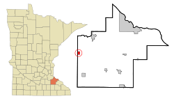
Location of Dennison, Minnesota
|
|
| Country | United States |
| State | Minnesota |
| Counties | Goodhue, Rice |
| Area | |
| • Total | 1.26 sq mi (3.26 km2) |
| • Land | 1.26 sq mi (3.26 km2) |
| • Water | 0.00 sq mi (0.00 km2) |
| Elevation | 1,034 ft (315 m) |
| Population
(2020)
|
|
| • Total | 223 |
| • Density | 176.98/sq mi (68.35/km2) |
| Time zone | UTC-6 (Central (CST)) |
| • Summer (DST) | UTC-5 (CDT) |
| ZIP code |
55018
|
| Area code(s) | 507 |
| FIPS code | 27-15706 |
| GNIS feature ID | 2394516 |
Dennison is a small city in the state of Minnesota, United States. It's unique because it's located in two different areas: Goodhue County and Rice County. Most of the city is in Goodhue County. According to the 2020 census, 223 people live there.
Contents
Discovering Dennison's Past
Dennison got its name from Morris P. Dennison. He was the first owner of the land where the city now stands. A post office opened in Dennison way back in 1885. This helped the community grow and connect with other places.
Exploring Dennison's Location
Dennison is a small city covering about 1.26 square miles (3.26 square kilometers). All of this area is land. There are no large lakes or rivers within the city limits.
If you're traveling near Dennison, you might see Highway 56 and Highway 246. These are important roads that help people get around the area. Goodhue County 9 is also a nearby road.
Who Lives in Dennison?
Dennison is a small community. The number of people living there has changed over the years. Here's a quick look at how the population has grown and shrunk:
| Historical population | |||
|---|---|---|---|
| Census | Pop. | %± | |
| 1910 | 184 | — | |
| 1920 | 218 | 18.5% | |
| 1930 | 262 | 20.2% | |
| 1940 | 216 | −17.6% | |
| 1950 | 163 | −24.5% | |
| 1960 | 179 | 9.8% | |
| 1970 | 203 | 13.4% | |
| 1980 | 176 | −13.3% | |
| 1990 | 152 | −13.6% | |
| 2000 | 168 | 10.5% | |
| 2010 | 212 | 26.2% | |
| 2020 | 223 | 5.2% | |
| U.S. Decennial Census | |||
A Look at the 2010 Population
In 2010, there were 212 people living in Dennison. These people lived in 77 different homes, and 53 of these were families. The city had about 168 people per square mile. There were 80 housing units, which are places where people can live.
Most of the people in Dennison were White (92.5%). A smaller number were African American (4.7%) or from two or more races (2.8%). About 1.4% of the population identified as Hispanic or Latino.
- Households: Out of the 77 homes, about 31% had kids under 18 living there.
- Families: Most homes (61%) were married couples living together.
- Age: The average age in Dennison was 39 years old.
- About 29% of residents were under 18.
- About 7.5% were 65 years old or older.
- Gender: Slightly more than half of the residents (51.4%) were male, and 48.6% were female.
See also
 In Spanish: Dennison (Minnesota) para niños
 | Laphonza Butler |
 | Daisy Bates |
 | Elizabeth Piper Ensley |

