
Denny Triangle, Seattle facts for kids
Quick facts for kids
Denny Triangle
|
|
|---|---|
|
Neighborhood
|
|
.jpg)
Denny Triangle and South Lake Union skyline in 2018
|
|

Denny Triangle Highlighted in Pink
|
|
| Country | United States |
| State | Washington |
| County | King |
| City | Seattle |
| ZIP Code |
98101, 98121
|
| Area Code | 206 |
The Denny Triangle is a neighborhood in Seattle, Washington, United States. It is located just north of Downtown Seattle. This area looks mostly flat today. But it was once a very steep hill!

The big hill was removed in a huge construction project. This project happened in the early 1900s. It was called the Denny Regrade. Sometimes, the neighborhood itself is still called the Denny Regrade. The name Denny Triangle refers to the part of this area that has grown a lot recently.
Like many neighborhoods, the Denny Triangle does not have exact borders. Different maps show slightly different areas. Generally, it is north of downtown Seattle. It stretches towards the Seattle Center grounds.
What Was Denny Hill?
.jpeg)
Seattle is built on a narrow strip of land. This land is between Lake Washington and Puget Sound. The city has many hills. These hills were formed by giant sheets of ice called glaciers. Long ago, these glaciers moved south. When they melted, they left behind piles of rock and dirt.
Denny Hill was one of these hills. It was located north of what is now downtown Seattle. Another famous hill is Queen Anne Hill. People started to remove Denny Hill in 1898. The project finished in 1930.

The Amazing Regrading Projects

The Denny Regrade project was all about removing Denny Hill. This hill was one of Seattle's famous "seven hills." It stretched from First Avenue to Denny Way. The hill and a street were named after the Denny family. They were some of the first white settlers in the city.
The first part of the regrade started in 1897. It finished in 1899. From 1902 to 1911, a huge amount of the hill was washed away. Workers used water from Lake Union. They pumped it with powerful machines. This process was like hydraulic mining. The dirt and mud were washed into Elliott Bay. This was called Denny Regrade No. 1. It removed everything between Fifth Avenue and the waterfront.
Later, in 1929 and 1930, the last parts of the hill were removed. This was Denny Regrade No. 2. For this part, workers used large steam shovels. These machines dug up the remaining dirt east of Fifth Avenue. It was a massive effort to flatten the land for new buildings.
Images for kids
-
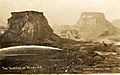
Postcard of the 1902–1911 regrade
-
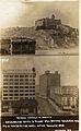
Postcard of the 1902–1911 regrade
-
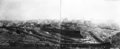
November 1929 photo of the last regrade, in progress


