Diogo Ribeiro facts for kids

Diogo Ribeiro (died August 16, 1533) was a skilled mapmaker and explorer from Portugal. He spent most of his life working in Spain, where people knew him as Diego Ribero. He was very important for creating official maps called the Padrón Real (or General Register) from 1518 to 1532. Diogo also built tools for navigation, like astrolabes and quadrants, which helped sailors find their way.
Contents
Early Life
We don't know exactly when or where Diogo Ribeiro was born. His parents were Afonso Ribeiro and Beatriz d’Oliveira. It's thought that he became a sailor when he was young. He traveled to India many times as a ship's pilot, guiding vessels. Reports say he sailed with Pedro Afonso de Aguiar. Pedro was a captain on voyages with famous explorers like Vasco da Gama and Afonso de Albuquerque.
Career
Around 1516, Diogo Ribeiro and other Portuguese navigators and mapmakers moved to Seville, Spain. They chose to work for the new King of Spain, Charles V. Among them were famous explorers like Ferdinand Magellan. Ribeiro started working for King Charles I of Spain in 1518. He became a mapmaker at the Casa de Contratación in Seville. This was a special Spanish government agency that controlled trade and exploration. Ferdinand Magellan helped create the maps used for the first trip around the world.
On January 10, 1523, Diogo Ribeiro was named the Royal Cosmographer. This meant he was the "master in the art of creating maps, astrolabes, and other instruments." He later took over as the main mapmaker after Sebastian Cabot left for a voyage.
In 1524, Ribeiro took part in a meeting called the Conference of Badajoz. Here, Spain and Portugal discussed where the Philippines belonged. They wanted to know if the islands were on Spain's side or Portugal's side of the Treaty of Tordesillas. This treaty had divided the world between the two countries.
In 1527, Ribeiro finished the Padrón Real. This was the official and secret Spanish map. It was used as the main map for all Spanish ships.
In 1531, he invented a new bronze water pump. This pump could move water ten times faster than older models.
Diogo Ribeiro died on August 16, 1533.
World Map
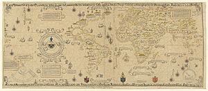
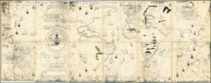
Ribeiro's most important work is his 1527 Padrón Real map. There are six copies of maps believed to be made by Ribeiro. These include one at the Weimar Grand Ducal Library (the 1527 Mundus Novus) and another at the Vatican Library (the 1529 Propaganda Map or Carta Universal). The design of his world map (Mapamundi) was greatly influenced by information gathered during Magellan and Elcano's trip around the world.
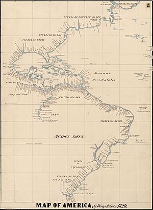
Diogo's map shows the coasts of Central and South America very accurately. It displays the entire east coast of the Americas. For the west coast, it shows the area from Guatemala to Ecuador. However, Australia and Antarctica are not on the map. The Indian subcontinent also appears too small.
His map was the first to show the true size of the Pacific Ocean. It was also the first map to show the North American coast as one continuous line. This was likely influenced by Estêvão Gomes's explorations in 1524 and 1525. The map also clearly shows the dividing line from the Treaty of Tordesillas.
See also
- Cartography of Latin America


