Divide, Colorado facts for kids
Quick facts for kids
Divide, Colorado
|
|
|---|---|

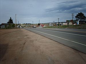
Divide from Ute Pass.
|
|
| Motto(s):
Center of the Known Universe
|
|

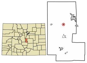
Location of the Divide CDP in Teller County, Colorado.
|
|
| Country | |
| State | |
| County | Teller County |
| Government | |
| • Type | unincorporated town |
| Area | |
| • Total | 0.336 sq mi (0.869 km2) |
| • Land | 0.336 sq mi (0.869 km2) |
| • Water | 0 sq mi (0.000 km2) |
| Elevation | 9,117 ft (2,779 m) |
| Population
(2020)
|
|
| • Total | 143 |
| • Density | 426.2/sq mi (164.6/km2) |
| Time zone | UTC-7 (MST) |
| • Summer (DST) | UTC-6 (MDT) |
| ZIP Code |
80814
|
| Area code(s) | 719 |
| GNIS feature | Divide CDP |
Divide is a small community in Teller County, Colorado, United States. It's known as an unincorporated town, which means it doesn't have its own local government like a city does. It also has a post office and is recognized as a census-designated place (CDP). This means the U.S. Census Bureau collects information about its population. Divide is part of the larger Colorado Springs, CO Metropolitan Statistical Area. In 2020, about 143 people lived in Divide.
Contents
History of Divide
The Divide Post Office started operating in 1889. The town got its name because of its special location. It sits near Ute Pass, which is a natural "divide" between two major river systems. One side of the pass sends water towards the Arkansas River, and the other side sends water towards the Missouri River.
Geography and Location
Divide is located on the northern side of the famous Pikes Peak mountain. Just west of town is Ute Pass, a mountain pass. Divide is also where two important roads meet: U.S. Highway 24 and State Highway 67. These highways run together for a bit as they head east towards Woodland Park.
The area of Divide, as defined by the census, covers about 0.869 square kilometers (or about 0.336 square miles). All of this area is land.
Climate in Divide
Divide experiences a mountain climate. Here's a look at the average temperatures and precipitation throughout the year:
| Climate data for Divide 4NW, Colorado, 1991–2020 normals: 9134ft (2784m) | |||||||||||||
|---|---|---|---|---|---|---|---|---|---|---|---|---|---|
| Month | Jan | Feb | Mar | Apr | May | Jun | Jul | Aug | Sep | Oct | Nov | Dec | Year |
| Mean daily maximum °F (°C) | 32.7 (0.4) |
34.4 (1.3) |
41.3 (5.2) |
46.8 (8.2) |
56.5 (13.6) |
68.5 (20.3) |
74.3 (23.5) |
71.4 (21.9) |
65.3 (18.5) |
53.6 (12.0) |
41.5 (5.3) |
32.6 (0.3) |
51.6 (10.9) |
| Daily mean °F (°C) | 21.0 (−6.1) |
22.5 (−5.3) |
29.4 (−1.4) |
34.7 (1.5) |
43.9 (6.6) |
54.9 (12.7) |
60.5 (15.8) |
58.1 (14.5) |
51.9 (11.1) |
40.4 (4.7) |
29.7 (−1.3) |
22.4 (−5.3) |
39.1 (4.0) |
| Mean daily minimum °F (°C) | 9.3 (−12.6) |
10.5 (−11.9) |
17.5 (−8.1) |
22.6 (−5.2) |
31.2 (−0.4) |
41.2 (5.1) |
46.6 (8.1) |
44.7 (7.1) |
38.5 (3.6) |
27.1 (−2.7) |
17.8 (−7.9) |
12.3 (−10.9) |
26.6 (−3.0) |
| Average precipitation inches (mm) | 0.66 (17) |
0.74 (19) |
1.45 (37) |
2.10 (53) |
2.03 (52) |
1.77 (45) |
3.72 (94) |
3.24 (82) |
1.90 (48) |
0.94 (24) |
0.69 (18) |
0.74 (19) |
19.98 (508) |
| Average snowfall inches (cm) | 10.1 (26) |
16.6 (42) |
14.8 (38) |
19.3 (49) |
10.9 (28) |
0.5 (1.3) |
trace | trace | 1.0 (2.5) |
5.7 (14) |
9.4 (24) |
11.0 (28) |
99.3 (252.8) |
| Source 1: NOAA | |||||||||||||
| Source 2: XMACIS (snowfall) | |||||||||||||
Population and Demographics
The United States Census Bureau first officially counted the population of Divide as a CDP for the United States Census 2010. A census is like a big count of all the people living in an area. It helps us understand how communities are growing or changing.
| Divide CDP, Colorado | ||
|---|---|---|
| Year | Pop. | ±% |
| 2010 | 127 | — |
| 2020 | 143 | +12.6% |
| Source: United States Census Bureau | ||
As you can see, the population of Divide has grown a little bit over the years. In 2010, there were 127 people, and by 2020, that number increased to 143.
See also
 In Spanish: Divide (Colorado) para niños
 | Emma Amos |
 | Edward Mitchell Bannister |
 | Larry D. Alexander |
 | Ernie Barnes |


