Dongola, Illinois facts for kids
Quick facts for kids
Dongola
|
|
|---|---|

Dongola
|
|

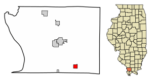
Location of Dongola in Union County, Illinois.
|
|

Location of Illinois in the United States
|
|
| Country | United States |
| State | Illinois |
| County | Union |
| Area | |
| • Total | 1.15 sq mi (2.97 km2) |
| • Land | 1.09 sq mi (2.82 km2) |
| • Water | 0.06 sq mi (0.15 km2) |
| Elevation | 397 ft (121 m) |
| Population
(2020)
|
|
| • Total | 661 |
| • Density | 607.54/sq mi (234.49/km2) |
| Time zone | UTC-6 (CST) |
| • Summer (DST) | UTC-5 (CDT) |
| ZIP Code(s) |
62926
|
| Area code(s) | 618 |
| FIPS code | 17-20305 |
| GNIS ID | 2398735 |
| Wikimedia Commons | Dongola, Illinois |
Dongola (pronounced don-GO-luh) is a small village located in Union County, Illinois, in the United States. In 2010, about 726 people lived there. By 2020, the population was 661.
Contents
History of Dongola Village
Dongola was started in 1857. It was planned as a stop along the Illinois Central Railroad, which was a very important train line.
How Dongola Got Its Name
Before it was called Dongola, there was a post office nearby named "Unionville" in 1855. But when the village was officially set up, its name was changed to "Dongola." This new name came from Dongola, Sudan, a place far away in Africa.
Geography of Dongola
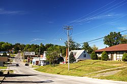
Dongola is located at coordinates 37°21′40″N 89°9′52″W. It is north of Cairo. You can find it where Old U.S. Highway 51 (also called Front Street in Dongola) crosses Interstate 57.
Nearby Areas and Features
Just southwest of Dongola, three counties meet: Union, Pulaski, and Alexander counties. To the west of the village, there is a place called Dongola Lake. This lake was made by a small dam on a stream called Little Creek.
Land and Water Area
In 2010, Dongola covered a total area of about 1.15 square miles (2.97 square kilometers). Most of this area, about 1.09 square miles (2.82 square kilometers), is land. The rest, about 0.06 square miles (0.15 square kilometers), is water.
Dongola Population Facts
| Historical population | |||
|---|---|---|---|
| Census | Pop. | %± | |
| 1880 | 599 | — | |
| 1890 | 733 | 22.4% | |
| 1900 | 681 | −7.1% | |
| 1910 | 702 | 3.1% | |
| 1920 | 660 | −6.0% | |
| 1930 | 635 | −3.8% | |
| 1940 | 638 | 0.5% | |
| 1950 | 704 | 10.3% | |
| 1960 | 757 | 7.5% | |
| 1970 | 825 | 9.0% | |
| 1980 | 886 | 7.4% | |
| 1990 | 728 | −17.8% | |
| 2000 | 806 | 10.7% | |
| 2010 | 726 | −9.9% | |
| 2020 | 661 | −9.0% | |
| U.S. Decennial Census | |||
According to the census from the year 2000, there were 806 people living in Dongola. These people made up 330 households and 222 families. The village had about 729 people per square mile.
Who Lives in Dongola?
In 2000, most people in Dongola were White. A small number of people were African American, Native American, or Asian. Some people were from other backgrounds or a mix of two or more races. A very small number were Hispanic or Latino.
Households and Families
Out of the 330 households, about 33% had children under 18 living with them. Nearly half (48.5%) were married couples living together. About 15.8% were households where a female was in charge and her husband was not present. About 30.6% of all households were made up of just one person.
Age Groups in the Village
The population in Dongola was spread out across different age groups.
- About 27.5% of the people were under 18 years old.
- About 8.2% were between 18 and 24 years old.
- About 27.8% were between 25 and 44 years old.
- About 19.9% were between 45 and 64 years old.
- About 16.6% were 65 years old or older.
The average age in the village was 35 years.
See also
 In Spanish: Dongola (Illinois) para niños
 | Stephanie Wilson |
 | Charles Bolden |
 | Ronald McNair |
 | Frederick D. Gregory |


