
Dowsborough facts for kids

Seen from just north of Nether Stowey.
|
|
| Location | near Nether Stowey |
|---|---|
| Region | Somerset, England |
| Coordinates | 51°8′43.56″N 3°12′5.42″W / 51.1454333°N 3.2015056°W |
| Type | Hill fort |
| History | |
| Periods | Iron Age |
| Site notes | |
| Condition | some damage |
Dowsborough Camp is an ancient hill fort located on the Quantock Hills in Somerset, England. People sometimes call it Danesborough or Dawesbury. This fort was built during the Iron Age, a time long ago when people used iron tools.

Dowsborough Camp is a very important historical site. It has been officially recognized as a Scheduled Ancient Monument (No: 189456). This means it is protected by law because of its historical value. However, the fort and a nearby ancient burial mound are currently on the Heritage at Risk Register. This is because they are in danger of being damaged by vehicles and natural wear and tear.
What is Dowsborough Camp Like?

This ancient fort sits high up, about 340 meters (1115 feet) above sea level. It is on a part of the Quantock ridge that sticks out towards the east. From here, you can see amazing views. You can look north towards the Bristol Channel and east over the River Parrett valley.
The fort itself is shaped like an oval. It has one main wall, called a rampart, and a ditch around it. This type of fort is called univallate, meaning it has a single set of defenses. These defenses follow the natural shape of the hilltop. The fort covers an area of about 2.7 hectares (6¾ acres).
The main way into the fort is on the east side, which faces towards Nether Stowey. There is also a simpler opening on the north-west side. This opening lines up with an old path that goes down to Holford. To the west of the fort, in a small valley, are the Lady's Fountain springs.
A low area of land, called a col, connects the hill to the main Stowey ridge in the south. Here, you can find an old earthwork known as Dead Woman's Ditch. This extra wall would have given more protection against attacks from the main Quantock ridge to the west. It might also have marked the boundary between different ancient tribes.
Dowsborough in Saxon Times
During the Saxon era, a military road used by King Alfred passed nearby. This road was called the Herepath. It started from places like Combwich and Cannington. Some historians think Cannington might have been where the Battle of Cynwit took place.
The Herepath followed the path of the modern Stowey road. It crossed Dead Woman's Ditch and continued south along the main Quantock ridge. The road then went west towards the Brendon Hills and Exmoor. This important road connected many forts and lookout posts. It helped King Alfred's armies move quickly along the coast. This allowed them to watch for Viking ships and stop any raids on land.
The path leading from Dowsborough to the Herepath is known as Great Bear Path. Many believe this name is a changed version of Great Herepath. This suggests that Dowsborough Camp might have been used as a Saxon lookout point. From its high position, soldiers could watch over the Bristol Channel for any signs of Viking activity.
Images for kids
-
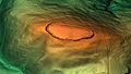
This image shows a 3D view of Dowsborough Camp.

