
Quantock Hills facts for kids
Quick facts for kids Quantock Hills |
|
|---|---|

Upland scrub in the Quantocks
|
|

Location of the Quantock Hills AONB in the UK
|
|
| Location | Somerset, England |
| Area | 38 sq mi (98 km2) |
| Governing body | Quantock Hills AONB |
The Quantock Hills are a beautiful area in Somerset, England, west of Bridgwater. They are made up of open heathland, old oak forests, ancient parklands, and farmland. In 1956, they became England's very first Area of Outstanding Natural Beauty. This means they are a special place protected for their amazing natural beauty.
The Quantock Hills are considered a "national character area" by Natural England. They are completely surrounded by another such area, called the Vale of Taunton and Quantock Fringes.
These hills stretch for about 15 miles (24 km) from the Vale of Taunton Deane in the south, all the way to the coast at Kilve and West Quantoxhead on the Bristol Channel. They form the western edge of the Sedgemoor area and the Somerset Levels. On a clear day, from the top of the hills, you can see far and wide! You might spot Glastonbury Tor and the Mendip Hills to the east, Wales (even the Gower Peninsula) to the north, the Brendon Hills and Exmoor to the west, and the Blackdown Hills to the south. The highest point in the Quantocks is Wills Neck, which is 1,261 feet (384 m) high. The different types of soil and weather here help many unique plants and animals to thrive. In 1970, a large area of 6,194.5 acres (2,506.8 ha) was made a Site of Special Scientific Interest, meaning it's a very important place for nature.
You can find many signs of ancient history in the Quantocks. There are Bronze Age burial mounds, old field systems, and Iron Age hill forts. Even Roman silver coins have been found near West Bagborough. The hills are a popular spot for people who love to walk, mountain bike, ride horses, and explore paths like the Coleridge Way.
Contents
- What's in a Name? Quantock's History
- Quantock Hills: Rocks and Landscape
- Weather in the Quantocks
- Nature and Wildlife in the Quantocks
- A Look Back: Quantock History
- Walking and Exploring the Quantocks
- How the Quantocks are Managed
- Who Owns the Quantock Hills?
- Fun Places to Visit in the Quantocks
- Images for kids
What's in a Name? Quantock's History
The name "Quantock" first appeared in old Saxon writings around AD 880 as Cantuctun. Later, in the Domesday Book, it was written as Cantoctona and Cantetone. The name means "settlement by a rim or circle of hills." Cantuc is an old Celtic word for a rim or circle, and -ton or -tun is an Old English word for a settlement.
The highest point, Will's Neck, means "ridge of the Welshman." This name likely comes from a time when the hills were a border between the growing Saxon kingdom of Wessex and the lands of the Britons (who were sometimes called 'Welsh') to the west. A battle was even fought nearby during that period.
Quantock Hills: Rocks and Landscape

The Quantock Hills are mostly made of rocks from the Devonian period. These rocks were formed from sediments that settled at the bottom of a shallow sea a very long time ago and slowly turned into solid rock. In the higher, north-western parts, you'll find older rocks called Hangman Grits. You can see these rocks clearly at West Quantoxhead quarry, where they were once dug up to build roads.
Further south, there are newer Devonian rocks, including sandstone and limestone. Limestone from here was quarried near Aisholt. There's even a special limestone cave at Great Holwell, south of Aisholt. The lower areas around the hills have younger rocks from the Triassic period. These rocks were also formed in a shallow sea and often contain gypsum, which was once mined on the beach at Watchet.
Some parts of the hills have outcrops of slate. Even younger rocks from the Jurassic period can be found between St Audries and Kilve. This coastal area is so important for geology that it's part of a Site of Special Scientific Interest.
At Kilve, you can see the remains of a brick building from 1924. This was a "retort" built to get oil from the shale in the cliffs, which was rich in oil. The cliffs along this coast have layers of oil-bearing shale and different types of Lias rock, which contain fossils. A company tried to get oil here, but it didn't work out.
At Blue Anchor, the colourful alabaster found in the cliffs gave its name to the colour "Watchet Blue." The village also has a very old brick kiln from around 1830, which was used to make bricks.
A special greenish-grey rock called Cockercombe tuff is found mostly in the south-eastern Quantock Hills. It was formed from compressed volcanic ash.
Weather in the Quantocks

Like the rest of South West England, the Quantock Hills have a temperate climate. This means it's generally wetter and milder than other parts of England. The average temperature is about 10 °C (50 °F). Temperatures change with the seasons and throughout the day, but the sea helps keep the changes smaller than in many other places in the UK. January is the coldest month, and July and August are the warmest.
December is usually the cloudiest month, and June is the sunniest. When there's high pressure over the Azores, it often brings clear skies to south-west England, especially in summer. Clouds often form inland, especially near hills, which can reduce sunshine. On average, the area gets about 1,600 hours of sunshine each year.
Rainfall is usually linked to Atlantic weather systems or to thunderstorms. In summer, the sun heating the ground can cause shower clouds to form, so a lot of rain comes from showers and thunderstorms. The average rainfall is about 31 to 35 inches (790 to 890 mm) per year. Snowfall is typical for about 8 to 15 days a year. Winds are strongest from November to March and lightest from June to August. The wind usually blows from the south-west.
Nature and Wildlife in the Quantocks
In 1970, a large area of 6,194.5 acres (2,506.8 ha) in the Quantocks was named a Site of Special Scientific Interest (SSSI). This is a special conservation designation in the UK, chosen by Natural England, for places with unique landscapes and wildlife. It helps protect these areas from building and other damage, and also from being neglected.
The streams and open water, like Hawkridge Reservoir and Ashford Reservoir, also create homes for many different kinds of animals.
Amazing Plants of the Quantocks

The tops of the hills are covered in heathland with gorse, heather, bracken, and thorn bushes. There are also areas with planted conifer trees. The western side of the Quantocks has steep slopes with pastures, woods, and parkland. Deep, stream-carved valleys (called "combes") in the north-east have large oak forests and small bogs full of flowers.
In areas where water doesn't drain well, you'll find lots of heather (Calluna vulgaris), along with cross-leaved heath (Erica tetralix), purple moor-grass (Molinia caerulea), bilberry (Vaccinium myrtillus), and wavy hair-grass (Deschampsia flexuosa). Drier spots have bell heather (Erica cinerea), western gorse (Ulex gallii), and bristle bent (Agrostis curtisii). Bracken (Pteridium aquilinum) grows commonly in well-drained, deeper soils. The springs and streams are home to special plants like bog pimpernel (Anagallis tenella). The woodlands are mostly made up of birch and oak, alder, or ash and elm trees, which support many different lichens. Alfoxton Wood is one of only three places in Britain where the lichen Tomasellia lectea grows!
Animals and Their Life Cycles
The different habitats, slopes, and sun exposure in the Quantocks create perfect conditions for many animals. In the wetter areas, you can find amphibians like the palmate newt (Triturus helveticus), common frog (Rana temporaris), and common toad (Bufo bufo).
Reptiles here include the adder (Vipera berus), grass snake (Natrix natrix), slowworm (Anguis fragilis), and common lizard (Lacerta vivipara). Many bird species also breed in the Quantocks, such as the grasshopper warbler (Locustella naevia), nightjar (Caprimulgus europaeus), raven (Corvus corax), and the European pied flycatcher (Ficedula hypoleuca). The Quantocks are also an important home for red deer (Cervus elaphus). Interesting insects include the silver-washed fritillary butterfly (Argynnis paphia) and three rare beetles that live in dead wood: Thymalus limbatus, Orchesia undulata, and Rhinosimus ruficollis.
A Look Back: Quantock History
Ancient Times in the Quantocks
We know people lived in the Quantocks long ago. Mesolithic flint tools have been found at North Petherton and Broomfield. There are also many Bronze Age round barrows (burial mounds), like Thorncombe Barrow above Bicknoller. You can see ancient stones like the Triscombe Stone and the Long Stone above Holford. Many of the paths along the Quantock ridges were probably old "ridgeways" used for travel. A Bronze Age hill fort called Norton Camp was built to the south, near a bronze-making center in Taunton.

During the Iron Age, important hill forts like Dowsborough and Ruborough were built in the Quantocks. There were also smaller earthwork enclosures, such as Trendle Ring and Plainsfield Camp. Ruborough, near Broomfield, is on a hill spur with steep natural slopes. It's a triangular fort with a single rampart (wall) and ditch, covering about 4 acres (1.6 ha). The name Ruborough means "Rough Hill." The Dowsborough fort is oval-shaped, also with a single rampart and ditch, covering about 7 acres (2.8 ha).
There isn't much evidence of a strong Roman presence in the Quantocks, just a few scattered finds. A Roman port was at Combwich, and it's possible a Roman road ran from there to the Quantocks. The names Nether Stowey and Over Stowey come from an Old English phrase meaning "stone way." In 2001, a treasure of 4th-century Roman silver coins, called the West Bagborough Hoard, was found near West Bagborough. It included 681 coins from different Roman emperors and mints.
Dark Ages and Anglo-Saxon Times
The Quantock area was controlled by Celts until about 681–685 AD. Then, Centwine of Wessex expanded his kingdom west, conquering the Welsh King Cadwaladr and taking over the rest of Somerset. Saxon rule became stronger under King Ine, who built a fort at Taunton around 700 AD.
The village of Crowcombe was first mentioned in writing in 854. At that time, it belonged to Glastonbury Abbey. Later, King Alfred led the fight against Viking invaders from his base at Athelney, south-east of the Quantocks. According to old records, the port at Watchet was attacked by Danes in 987 and 997. King Alfred created a system of forts and lookout posts connected by a military road, or herepath, to help his army track Viking movements. This herepath was a wide track, about 66-foot (20 m), with tree-lined embankments. It ran from the River Parrett at Combwich, past Cannington hill fort, to Over Stowey, and then up the Quantocks to Crowcombe Park Gate. It continued south along the ridge to Triscombe Stone. There's also some evidence that a part of the hills, Quantock Common, might have been a Saxon Royal Forest.
Medieval Period
After the Norman conquest of England in 1066, William de Moyon was given land in places like Dunster, Broomfield, and West Quantoxhead. East Quantoxhead was given to the Luttrell family, who owned it for centuries.
Stowey Castle at Nether Stowey was built in the 11th century. It was on a small hill and had a square tower and defensive walls. The castle was destroyed in the 15th century, possibly as a punishment for the local Lord Audley's part in a rebellion against King Henry VII. Some of its stones were used to build Stowey Court in the village.
Modern History
The Quantocks saw little fighting during the English Civil War. Sir John Stawell of Cothelstone was a strong supporter of the King. After the war, when the King was restored, Charles II gave the title of Baron Stawell to Blake's son Ralph.
At the end of the Monmouth Rebellion in 1685, many people who took part were executed in the Quantocks. This rebellion tried to overthrow King James II, who was unpopular because he was Roman Catholic. The rebellion failed, and many of Monmouth's supporters were executed or sent away to other countries by Judge Jeffreys.
Dodington was the site of the Buckingham Mine, where copper was dug up. This mine started before 1725 and was closed in 1801, though people tried to reopen it later.

In 1724, the spire of the Church of the Holy Ghost in Crowcombe was hit by lightning. The top part of the spire was removed and is now in the churchyard. Inside the church, you can see carved wooden bench-ends from 1534 that show old stories, like the Green Man and the legend of the men of Crowcombe fighting a two-headed dragon.
Norton Fitzwarren had a special boat lift on a canal from 1839 to 1867. During World War II, a prisoner of war camp was built here for Italian and German prisoners.
Walking and Exploring the Quantocks
The famous poet Samuel Taylor Coleridge lived in Nether Stowey in the Quantocks from 1797 to 1799. To remember him, a walking path called The Coleridge Way was created. This 36-mile (58 km) route starts in Nether Stowey and goes across the Quantocks, the Brendon Hills, and Exmoor, ending in Porlock.
The Quantock Greenway is another walking path that opened in 2001. It forms a figure-of-eight shape, with its center at Triscombe. The northern loop is 19 miles (31 km) long, and the southern loop is 18 miles (29 km). The path takes you through many different landscapes, including forests, private parklands, and fields.
The Macmillan Way West also follows the Quantocks ridge for several miles.
How the Quantocks are Managed
The Quantock Hills were named an Area of Outstanding Natural Beauty (AONB) in 1956. This was the very first such area in England!
Because many different groups share responsibility for the Quantock AONB, a special committee was set up in 1973. This committee includes representatives from local councils, Natural England, the Forestry Commission, the National Trust, and local farming groups. This committee helps create and carry out plans to manage and protect the Quantocks.
Who Owns the Quantock Hills?
There isn't just one owner of the open land or the forests in the Quantocks. Big landowners include the Forestry Commission, The National Trust, the Fairfield Estate, the Luttrell Estate, the Tetton Estate, Somerset County Council, and Friends of Quantock.
Fun Places to Visit in the Quantocks
"Music on the Quantocks" is a series of concerts held each year in villages around the Quantocks. Famous musicians and choral groups have performed there.
Coleridge Cottage in Nether Stowey is a historic house where the poet Samuel Taylor Coleridge lived. It was built in the 17th century and is now owned by the National Trust. You can visit it and see how people lived long ago.

At Aley is Quantock Lodge, a large 19th-century mansion made of a special green-grey rock. It used to be a family home, then a school, and now it's a center for events and summer camps for young people.
Broomfield is home to Fyne Court. This was once the home of Andrew Crosse, a pioneer in electricity in the 1800s. Since 1972, it has been owned by the National Trust and is now run as a nature reserve and visitor centre by the Somerset Wildlife Trust. The Quantock Hills AONB Service also has its main office here.

The Church of St Mary in Kingston St Mary dates back to the 13th century. Its tower, from the early 16th century, has interesting decorations like "hunky-punks" perched on the corners. These are carvings that don't have a function, unlike gargoyles that carry water. The churchyard has tombs of the Warre family, who owned nearby Hestercombe House. Hestercombe House is a historic country house that many people visit each year. Part of its grounds is a Site of Special Scientific Interest because it's a roosting place for Lesser horseshoe bats. The house was used as a military headquarters during World War II and is now owned by Somerset County Council.
The Norman Church of St Giles in Thurloxton is mostly from the 15th century. It's a listed building, meaning it's protected for its historical importance.

The West Somerset Railway (WSR) is a special heritage railway that runs along the edge of the Quantock Hills. It goes between Bishops Lydeard and Watchet, then inland to Washford, and back to the coast for the trip to Minehead. At 23 miles (37 km), it's the longest privately owned passenger railway line in the UK!
Halsway Manor in Halsway is now England's National Centre for Traditional Music, Dance, and Song. It's the only place in the UK where people can stay and learn about folk traditions. Part of the building dates back to the 15th century. The manor was once a hunting lodge and then a family home before becoming a folk music center in the 1960s.
Halswell House in Goathurst has parts from the Tudor period, but it was rebuilt in 1689. The surrounding park and 17 acres (6.9 ha) pleasure garden were created between 1745 and 1785. The grounds have many fish ponds, waterfalls, bridges, and interesting buildings, including the beautiful Temple of Harmony, which has been fully restored.
Images for kids
-
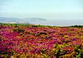
The Northern Flank of Beacon Hill (Quantocks). In late summer, the northern Quantocks are covered in purple heather and yellow gorse. You can see Minehead far away.
