
Wills Neck facts for kids
Quick facts for kids Wills Neck |
|
|---|---|

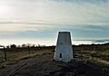
Trig point on top of Will's Neck
|
|
| Highest point | |
| Elevation | 1,261 ft (384 m) |
| Prominence | 863 ft (263 m) |
| Parent peak | Dunkery Beacon |
| Listing | Marilyn, Hardy |
| Geography | |
| Location | Quantock Hills, England |
| OS grid | ST165352 |
| Topo map | OS Landranger 181 |
Wills Neck is the highest point in the Quantock Hills in Somerset, England. It stands at 1261 feet (384 meters) high. Even though it's not super tall, it's special because it's known as a "Marilyn." A Marilyn is a hill in the British Isles that rises at least 492 feet (150 meters) above the land around it. Wills Neck is about 8 miles (13 km) northwest of the town of Taunton.
Contents
What's in a Name?
The name 'Wills Neck' comes from an old Saxon word. It means 'stranger' or 'foreigner'. Legend says it's linked to a local tribe called the Wealas. This tribe supposedly fought the Romans right here.
Amazing Views from the Top
When the weather is clear, the views from Wills Neck are incredible! You can see far-off places like Dartmoor and Exmoor. You might also spot the Brecon Beacons in Wales. Closer by, you can see the Mendips and Blackdown Hills. Sometimes, you can even see Pilsdon Pen in Dorset.
How Wills Neck Formed
Wills Neck is made from a type of rock called Hangman Grits. These rocks were formed a very long time ago. This was during a period called the Devonian Period. The Devonian Period was part of the Paleozoic Era. It started about 419 million years ago. It ended around 359 million years ago.
History of Wills Neck
Between 1922 and 1945, students from Clifton College studied Wills Neck. Their teacher, William Cornish Badcock, led them. They built a pile of stones, called a cairn, at the very top. Today, a modern trig point stands in the same spot. A trig point is a special marker. It helps mapmakers measure distances and heights.
Images for kids
-
A trig point helps mapmakers.
