
North Petherton facts for kids
Quick facts for kids North Petherton |
|
|---|---|
 Church of St Mary, North Petherton |
|

North Petherton
|
|
| Population | 6,730 |
| OS grid reference | ST290329 |
| Unitary authority |
|
| Ceremonial county | |
| Region | |
| Country | England |
| Sovereign state | United Kingdom |
| Post town | BRIDGWATER |
| Postcode district | TA6 |
| Dialling code | 01278 |
| Police | Avon and Somerset |
| Fire | Devon and Somerset |
| Ambulance | South Western |
| EU Parliament | South West England |
| UK Parliament |
|
North Petherton is a town in Somerset, England. It sits near the Quantock Hills and the Somerset Levels.
In 2014, about 6,730 people lived here. The area also includes smaller places like Hamp, Melcombe, Shearston, Woolmersdon, and Huntworth.
North Petherton has been an important settlement since the 10th century, during Saxon times. It was known as the largest village in England for a long time. It only became a town in the late 20th century.
Once, it was a busy market and administrative center. Today, many people who live in North Petherton work in nearby Bridgwater (about 5 km away) or Taunton (about 13 km away). The town center is special because it has a lot of hidden archaeological history. Many buildings here are also protected because they are old and important.
Contents
What's in a Name?
The town's name comes from its location. It's to the north of the River Parrett. In the Domesday Book from 1086, it was called Nortperet. This name combines "north" and an old English word for "farm" or "settlement."
A Look Back in Time
Long before the Normans arrived, North Petherton was a big royal estate during Saxon times. It was an important place and a meeting spot for the local area. Even today, the parish (a local administrative area) of North Petherton is one of the largest in Somerset.
The Royal Hunting Ground
King Henry II made the royal estate even bigger. He turned it into the Royal Forest of Petherton Park. This was a special hunting ground for the king and his nobles. It existed until the 17th century.
Did you know that Geoffrey Chaucer (who wrote The Canterbury Tales) worked here? He was a Deputy Forester in the Royal Forest of North Petherton towards the end of his life.
Town Development
It's believed the town grew up around a main church, called a minster. This church was likely on the same spot as the current church. Digs near the church have found evidence of wooden buildings from the late Saxon period. This suggests that the old Saxon settlement might still be buried under the town center.
In the 14th century, a cemetery was found near the church. It might have been used for people who died during the Black Death plague. North Petherton was allowed to hold a market in 1318, but people think markets happened there even before that.
During the English Civil War, a small fight happened in August 1644 in the town.
The Alfred Jewel

In 1693, a very special object was found in Petherton Park. It's called the Alfred Jewel. This object is about 6 cm long and made of gold with colorful enamel and a crystal cover.
Many people believe Alfred the Great ordered it to be made. It was probably the handle for a pointer used when reading books aloud. It has an inscription that says, "Alfred had me made." It might have been one of the special pointers Alfred sent to bishops with copies of a book he translated. You can see a copy of the jewel in the Church of St Mary in North Petherton.
Canals and Bridges

The Bridgwater and Taunton Canal opened in 1827. It used to connect to the River Parrett at Huntworth. However, the canal was later extended to Bridgwater. The old connection was filled in because the River Parrett has salty water and a lot of mud, which would harm the fresh water in the canal. The canal is still used to transport drinking water for Bridgwater.
The Crossways Swing Bridge over the canal was built in 1827. It's a wooden bridge that could rotate on steel ball-bearings. This was a very early use of ball bearings in such a way!
Early Street Lights
In 1906, North Petherton became the first town in Britain to have street lights lit by piped acetylene gas! This gas came from a local company. Later, in 1931, the town switched to coal gas and electricity.
Modern Developments
In 1984, North Petherton got a small public library. A few years later, a Community Centre was built and opened in 1987, providing a place for local events and groups.
How the Town is Run
North Petherton is a civil parish. This means it has its own local council, called a town council. This council handles local issues like setting a budget, checking building plans, and working with the police on safety and traffic. They also help maintain local facilities and roads.
The town council works with the larger Somerset Council, which is in charge of bigger services like fire, police, and ambulance.
North Petherton is also part of the Bridgwater area. This area elects one Member of Parliament (MP) to represent it in the UK Parliament.
Where is North Petherton?
North Petherton is on an old route through Somerset. In the 1730s, a special road (a turnpike) was opened through the town, connecting Bridgwater and Taunton. When the M5 motorway opened in the 1970s, it made the town even more popular for people who travel to work. This led to new homes being built.
South east of the town is North Moor. This is a very important natural area with special grasslands and ditches. It's home to many common and rare plants, and it's also important for birds.
Weather in North Petherton
North Petherton has a mild and often wet climate, like the rest of South West England. The average yearly temperature is about 10°C (50°F). Summers are warm, with average high temperatures around 21°C (70°F) in July and August. Winters are cooler, with average low temperatures around 1°C or 2°C (34°F or 36°F).
The area gets about 700 mm (28 inches) of rain each year. Snowfall is not very common, usually only 8 to 15 days a year. The wind usually blows from the south-west.
What the Town Does

North Petherton used to be a busy market town. It was given the right to hold a market and an annual fair in 1318.
In the past, the town had a brewery, places for making malt, and engineering workshops. Basket making was also a big industry here, employing over 100 people. They made baskets and wicker furniture. The town also used to produce cloth and leather goods.
Today, local jobs are mostly in service businesses and farming. There's also a place called Folly Foot Fishery, where you can fish for different types of carp.
In 2007, a new, large Regional Agricultural Business Centre opened near the town. It includes a big Cattle Market and a Dairy. This replaced older cattle markets in Taunton and Bridgwater.
Learning in North Petherton

North Petherton has one primary school, called North Petherton Primary School.
For older students, there are several secondary schools in nearby Bridgwater. These include Robert Blake Science College, Chilton Trinity School, and Haygrove School.
If you want to continue your education after secondary school, Bridgwater College offers further education courses.
Places of Worship

The town has a beautiful church called St Mary the Virgin. Its tower is very tall, at 34 meters (112 feet) high, and is known for its decorations. The church building is mostly from the 15th century. It has a special gallery from 1623 and a clock built in 1807. This church is considered a very important historic building.
The Church of St Peter has a tower that might be from Saxon times. The rest of this church was rebuilt in 1885.
The Church of St. Michael has parts from the Norman period and has been restored several times.
Local Culture
North Petherton has an exciting annual event called the North Petherton Carnival. It's part of the bigger West Country Carnival circuit. It takes place in November, usually on the second Saturday of the month. Many of the same groups and floats that are in the Bridgwater Carnival (which happens the Saturday before) also take part here.
The Walnut Tree is one of the hotels in the town. It's also the meeting place for the Pentathlon Carnival Club, one of the groups that takes part in the carnival.
Town Twinning
Since 1994, North Petherton has been twinned with the town of Ceaucé in Normandy, France. This means the two towns have a special friendship and often exchange visits.
Images for kids
-
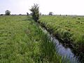
A drain on North Moor.

See also
 In Spanish: North Petherton para niños
