
Dry Run (West Branch Susquehanna River tributary) facts for kids
Quick facts for kids Dry Run |
|
|---|---|

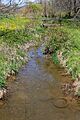
Dry Run looking upstream
|
|
| Physical characteristics | |
| Main source | low hill in Delaware Township, Northumberland County, Pennsylvania 611 ft (186 m) |
| River mouth | West Branch Susquehanna River in Delaware Township, Northumberland County, Pennsylvania near Watsontown 449 ft (137 m) 41°05′31″N 76°52′45″W / 41.09205°N 76.87915°W |
| Length | 4.1 mi (6.6 km) |
| Basin features | |
| Progression | West Branch Susquehanna River → Susquehanna River → Chesapeake Bay |
| Basin size | 3.98 sq mi (10.3 km2) |
| Tributaries |
|
Dry Run is a small stream, also called a tributary, located in Northumberland County, Pennsylvania. It flows into the West Branch Susquehanna River. The stream is about 4.1 miles (6.6 km) long. It travels through an area called Delaware Township.
The area of land that collects water for Dry Run is about 3.98 square miles (10.3 km2). This stream is important for fish and other water creatures. It is known as a Warmwater Fishery and a Migratory Fishery. This means it's a good home for fish that like warmer water, and also for fish that travel through it.
Contents
Where Does Dry Run Flow?

Dry Run starts on a small hill in Delaware Township. It flows generally north-northeast at first. Then, it slowly turns to flow west-northwest. After flowing for more than a mile, another small stream joins it. This stream is called an unnamed tributary.
The stream then enters a small community called Dewart. In Dewart, it continues to flow west-northwest. It then turns southwest and goes under a railroad track. After that, it flows south for a bit, leaving Dewart. It crosses over Pennsylvania Route 44/Pennsylvania Route 405. Finally, it turns west and soon reaches the West Branch Susquehanna River.
Dry Run joins the West Branch Susquehanna River about 16.87 miles (27.15 km) before the West Branch reaches its own end.
Stream Health: What is Hydrology?
Hydrology is the study of how water moves on and under the Earth. For Dry Run, it's important to know about its water quality. Dry Run is listed as an "impaired" waterbody. This means its water isn't as clean as it should be.
The main problem is sedimentation or siltation. This means there's too much dirt, sand, and mud in the water. This extra dirt often comes from farms nearby. It can make the water cloudy and harm the plants and animals living in the stream.
Sometimes, a lot of water flows through Dry Run, especially after heavy rains. This is called a "peak discharge." For example, at one point where a railroad crosses the stream, there's a 10 percent chance that the water flow could reach 1,080 cubic feet per second (31 m3/s) in a year.
Geography and Land Around Dry Run
The land around Dry Run is not very high. Near where the stream ends, its elevation is about 449 feet (137 m) above sea level. Where the stream begins, it's a bit higher, around 611 feet (186 m) above sea level.
Dry Run is considered a relatively small stream that flows through a valley.
The Dry Run Watershed
The watershed of Dry Run is the entire area of land where all the rain and snowmelt drain into this stream. It covers about 3.98 square miles (10.3 km2). The end of the stream is in an area mapped by the United States Geological Survey as the Allenwood quadrangle. The beginning of the stream is in the Milton quadrangle. The stream's mouth is also less than 1 mile (1.6 km) from the town of Watsontown.
A railroad track, once part of Conrail, crosses Dry Run. At this crossing, the watershed area is about 3.08 square miles (8.0 km2).
Groups like the Warrior Run Pathways Partnership believe Dry Run could be healthier. They suggest better ways to manage the stream and its watershed. This includes planting trees along the stream banks (called riparian buffers), putting up fences to keep farm animals out of the water, and managing farm waste. These actions help protect the stream's aquatic life.
History of Dry Run
Dry Run was officially added to the Geographic Names Information System on August 2, 1979. This system keeps track of names and locations of places in the United States.
Over the years, several bridges have been built over Dry Run to help people cross it.
- A concrete bridge for State Route 1005 was built in 1948. It's about 2 miles (3.2 km) north of Watsontown.
- Another concrete bridge for State Route 1003 was built in 1950 and fixed up in 2009. This one is about 1 mile (1.6 km) north of Watsontown.
- A bridge for Pennsylvania Route 44 was built in 1962. It's about 0.5 miles (0.80 km) north of Watsontown.
There are plans to fix up the Pennsylvania Route 44 bridge, which could cost a lot of money. In 2015, a local group called the Northumberland County Conservation District received a grant of $200,000. This money was from a program called Growing Greener. They used it to put up fences for animals and to help stabilize the stream banks of Dry Run. This helps stop dirt from washing into the stream.
Animals and Plants
The area around Dry Run is a designated Warmwater Fishery and a Migratory Fishery. This means it's a good place for fish that like warmer water, and also for fish that travel through the stream as part of their life cycle.
In 2015, there was a farm with cattle near where Dry Run begins. Efforts are being made to ensure that farming activities do not harm the stream's health.
Images for kids
-
Dry Run looking upstream
-
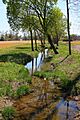
Dry Run looking downstream
